
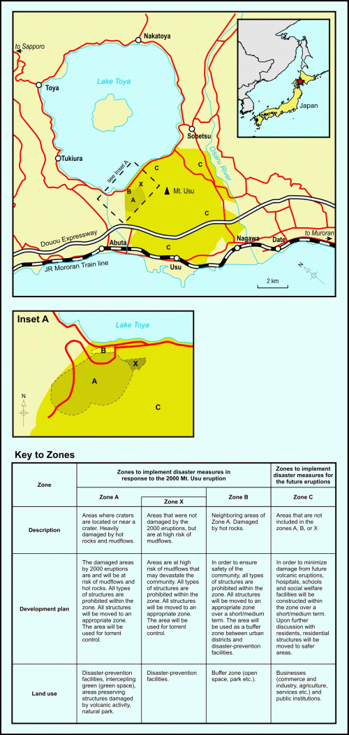
Land use zoning map for areas around Mount Usu
Usu (Toya), Japan, 2010
Figure 3 in: Becker, J.S., Saunders, W.S.A., Robertson, C.M., Leonard, G.S., & Johnston, D.M. (2010). A synthesis of challenges and opportunities for reducing volcanic risk through land use planning in New Zealand. The Australasian Journal of Disaster and Trauma Studies, 2010-1. (Simplified from: Nakao 2005)
This hazard map is the result of scientific research and was published in academic literature.
It is presented here to serve as an example of the map type or the map-making methodology. It is NOT the official, operational map. For the current operational hazard map, please consult the proper institutional authorities.
Click on image for full-size map. If link seems broken, try the archived version.
Becker, J.S., Saunders, W.S.A., Robertson, C.M., Leonard, G.S., & Johnston, D.M. (2010). A synthesis of challenges and opportunities for reducing volcanic risk through land use planning in New Zealand. The Australasian Journal of Disaster and Trauma Studies, 2010-1. Adapted from: Nakao, M. (2005). Eruption of Mt Usu, March 31 st 2000, at Mt Usu in Hokkaido. Failure Knowledge Database, 100 Selected Cases. Access date: 14 January 2009.Map Set
http://trauma.massey.ac.nz/issues/2010-1/becker.htm
Other Maps In Set: