
Advanced Search for Maps
Showing 1-10 of 29
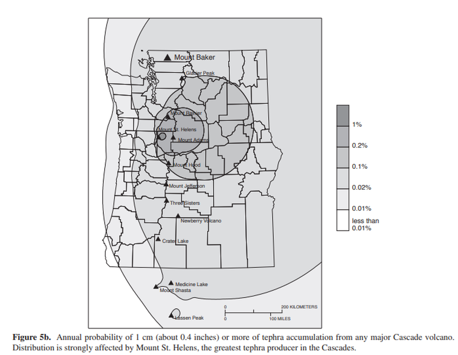
Official, Figure in hazard assessment
Annual probability of 1 cm (about 0.4 inches) or more of tephra accumulation from any major Cascade volcano
Figure 5b in: Gardner, C.A., Scott, K.M., Miller, C.D., Myers, B., Hildreth, W., & Pringle, P.T. (1995). Potential volcanic hazards from future activity of Mount Baker, Washington. U.S. Geological Survey, Open-File Report 95-498, 16 p., 1 plate, scale 1:100,000. https://doi.org/10.3133/ofr95498
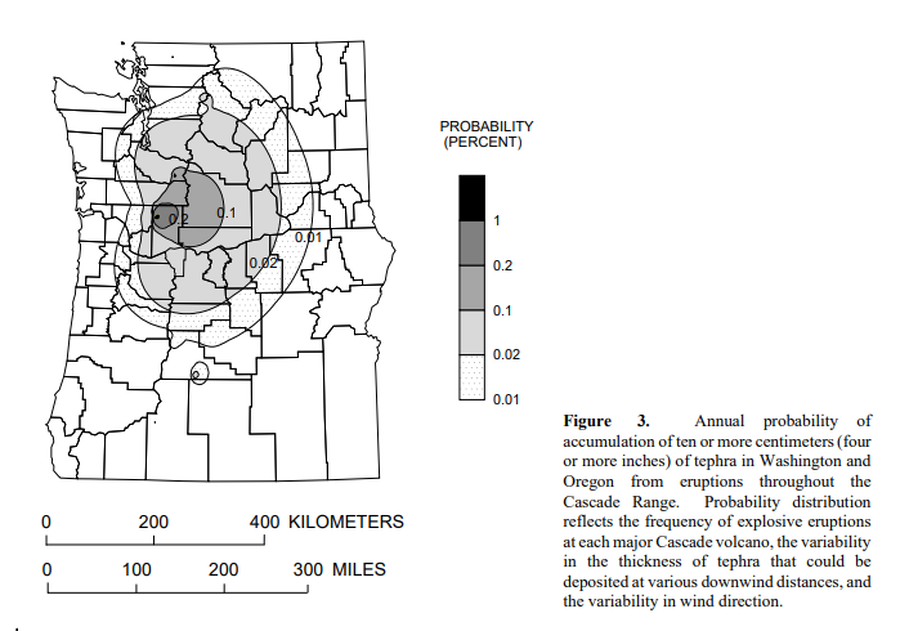
Official, Figure in hazard assessment
Annual probability of accumulation of ten or more centimeters (four or more inches) of tephra in Washington and Oregon from eruptions throughout the Cascade Range.
Figure 3 in: Wolfe, E.W. & Pierson, T.C. (1995). Volcanic-Hazard Zonation for Mount St. Helens, Washington, 1995. U.S. Geological Survey, Open-File Report 95-497, 12 p., 1 plate. https://doi.org/10.3133/ofr95497
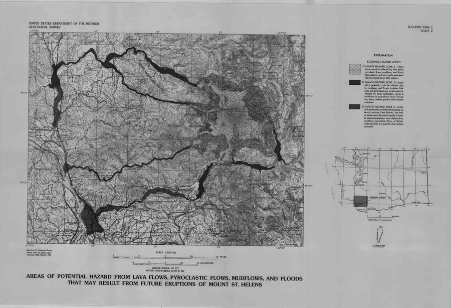
Official, Insert/poster-size map with accompanying report
Areas of Potential Hazard from Lava Flows, Pyroclastic Flows, Mudflows, and Floods that May Result from Future Eruptions of Mount St. Helens
Plate 2 in: Crandell, D.R. & Mullineaux, D.R. (1978). Potential Hazards from Future Eruptions of Mount St. Helens Volcano, Washington. U.S. Geological Survey, Bulletin 1383-C, 26 p. https://doi.org/10.3133/b1383C
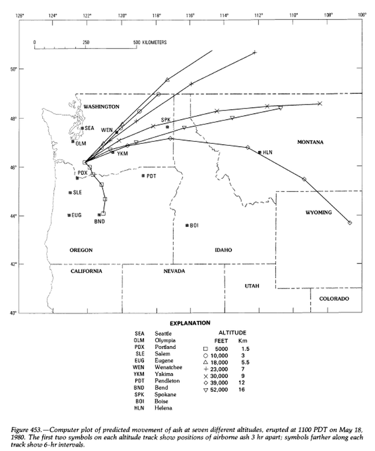
Official, Figure in hazard assessment
Computer plot of predicted movement of ash at seven different altitudes, erupted at 1100 PDT on May 18, 1980.
Figure 453 in: Miller, C.D., Mullineaux, D.R. & Crandell, D.R. (1981). Hazards assessments at Mount St. Helens. In: Lipman, P. W. & Mullineaux, D. R. (Eds.) The 1980 eruptions of Mount St. Helens, Washington. U.S. Geological Survey, Professional Paper 1250, p. 789-802. https://doi.org/10.3133/pp1250
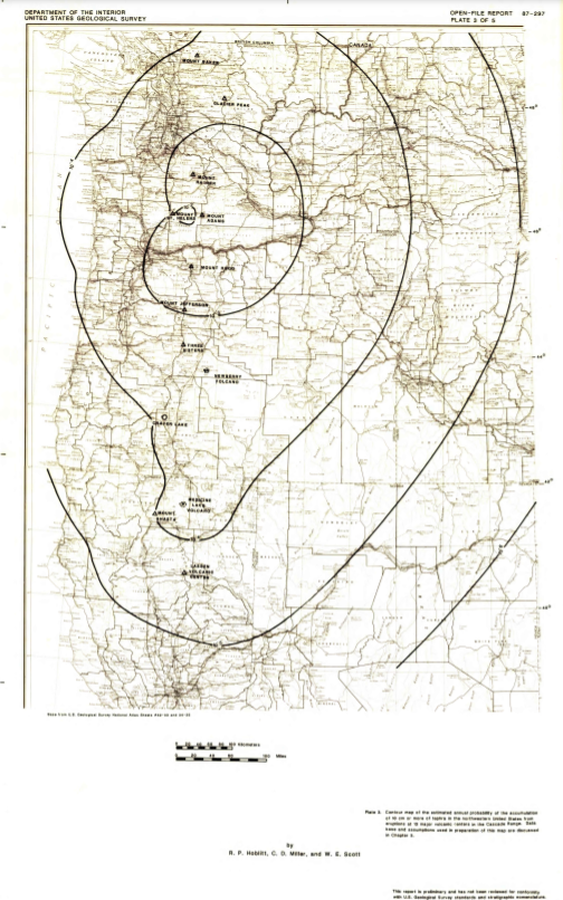
Official, Insert/poster-size map with accompanying report
Contour map of the estimated annual probability of the accumulation of 1 cm or more of tephra in the northwestern United States at eruptions at 13 major volcanic centers in the Cascades Range
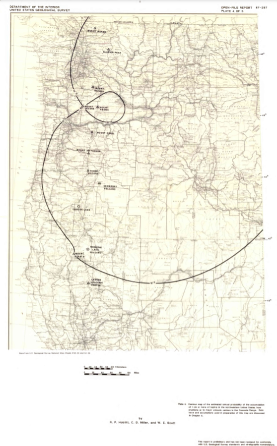
Plate 4 in: Hoblitt, R. P., Miller, C. D., & Scott, W. E. (1987). Volcanic hazards with regard to siting nuclear-power plants in the Pacific Northwest. U.S. Geological Survey, Open-File Report 87-297. https://doi.org/10.3133/ofr87297
Official, Insert/poster-size map with accompanying report
Contour map of the estimated annual probability of the accumulation of 1 m or more of tephra in the northwestern United States at eruptions at 13 major volcanic centers in the Cascades Range
Plate 2 in: Hoblitt, R. P., Miller, C. D., & Scott, W. E. (1987). Volcanic hazards with regard to siting nuclear-power plants in the Pacific Northwest. U.S. Geological Survey, Open-File Report 87-297. https://doi.org/10.3133/ofr87297
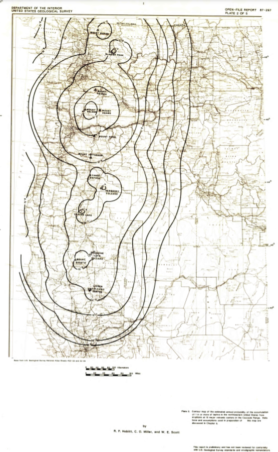
Official, Insert/poster-size map with accompanying report
Contour map of the estimated annual probability of the accumulation of 10 cm or more of tephra in the northwestern United States at eruptions at 13 major volcanic centers in the Cascades Range
Plate 3 in: Hoblitt, R. P., Miller, C. D., & Scott, W. E. (1987). Volcanic hazards with regard to siting nuclear-power plants in the Pacific Northwest. U.S. Geological Survey, Open-File Report 87-297. https://doi.org/10.3133/ofr87297
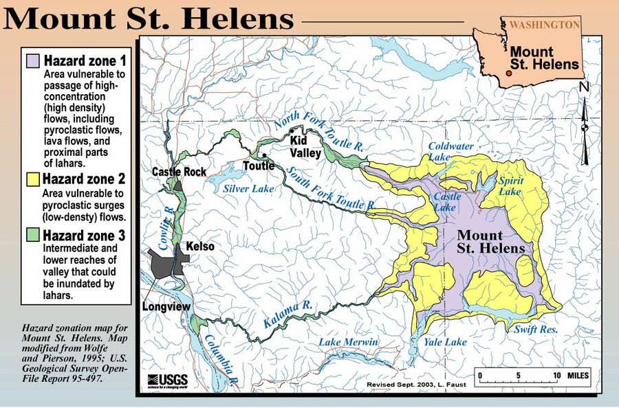
Official, Figure on website
Hazard Zonation Map for Mount St. Helens
Faust, L. (2003). Hazard zonation map for Mount St. Helens. U.S. Geological Survey. (Simplified from: Wolfe & Pierson 1995) (Reprinted in: Bluth, G. (Year Unknown). Mt. St. Helens Activity Update (+ 2004 events). Michigan Technological University, GE4150 Lecture. https://pages.mtu.edu/~gbluth/Teaching/GE4150/lecture_pdfs/L11_msh_seismic.pdf#page=2)
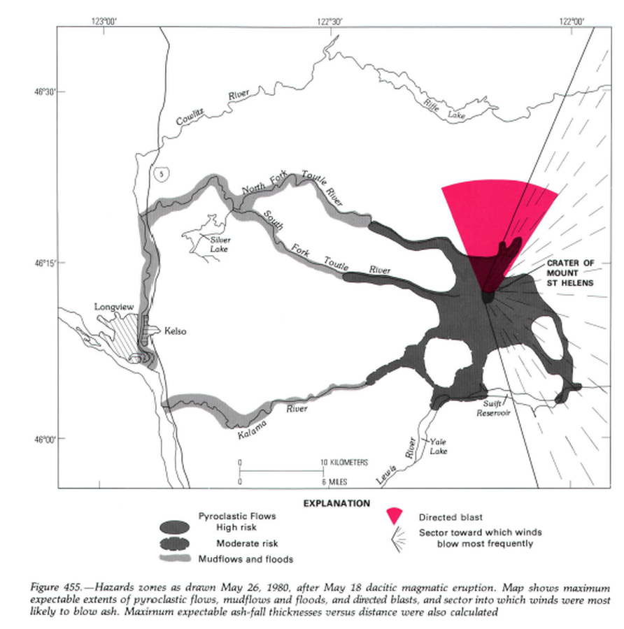
Official, Unknown format
Hazard zones as drawn May 26, 1980, after May 18 dacitic magmatic eruption.
Figure 455 in: Miller, C.D., Mullineaux, D.R. & Crandell, D.R. (1981). Hazards assessments at Mount St. Helens. In: Lipman, P. W. & Mullineaux, D. R. (Eds.) The 1980 eruptions of Mount St. Helens, Washington. U.S. Geological Survey, Professional Paper 1250, p. 789-802. https://doi.org/10.3133/pp1250
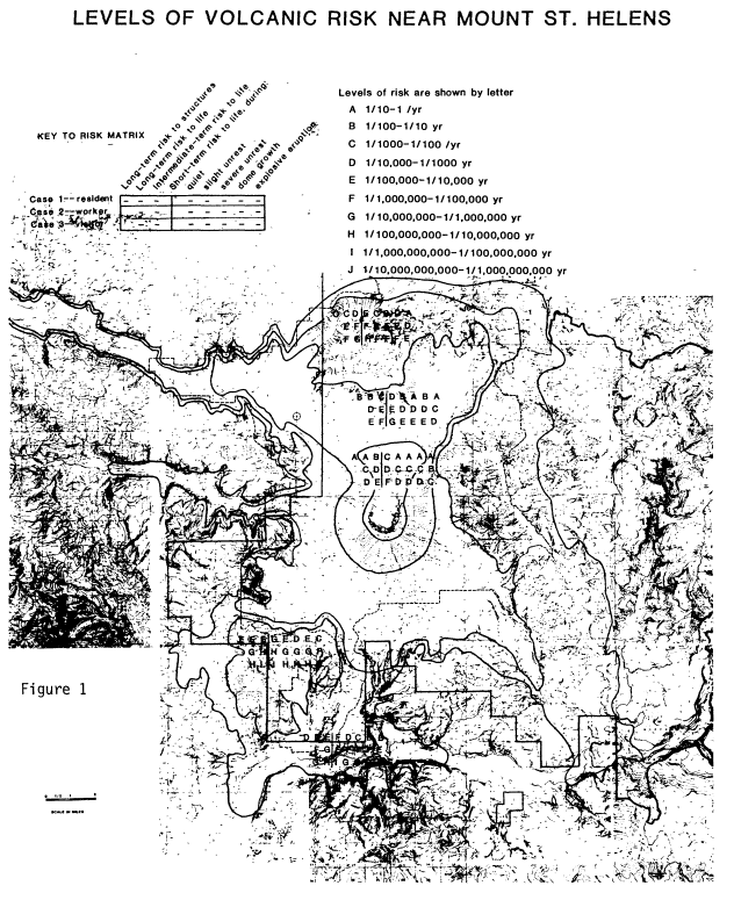
Official, Figure in hazard assessment
Levels of Volcanic Risk Near Mount St. Helens
Figure 1 in: Newhall, C.G. (1984). Semi-quantitative assessment of changing volcanic risk at Mount St. Helens, Washington. U.S. Geological Survey, Open-File Report 84-272, 30 p. doi:10.3133/ofr84272