
Advanced Search for Maps
Showing 1-10 of 46
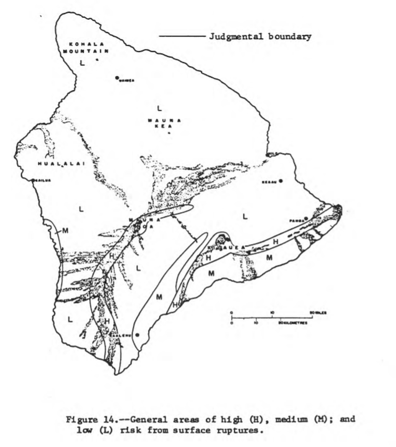
Official, Figure in hazard assessment
General areas of high (H), medium (M), and low (L) risk from surface ruptures
Figure 14 in: Mullineaux, D.R. & Peterson, D.W. (1974). Volcanic hazards on the Island of Hawaii. U.S. Geological Survey, Open-File Report 74-239. https://doi.org/10.3133/ofr74239
Official, Insert/poster-size map with accompanying report
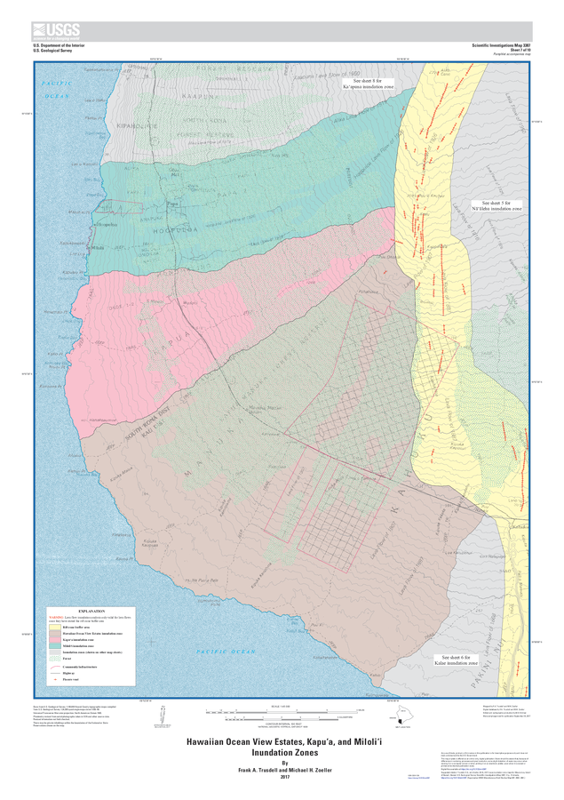
Hawaiian Ocean View Estates, Kapuʻa, and Miloliʻi Inundation Zones
Sheet 7 in: Trusdell, F.A. & Zoeller, M.H. (2017). Lava inundation zone maps for Mauna Loa, Island of Hawaiʻi, Hawaii. U.S. Geological Survey, Scientific Investigations Map 3387, 12 p., 10 sheets. https://doi.org/10.3133/sim3387
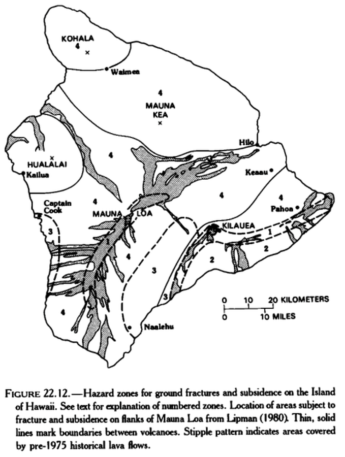
Official, Figure in hazard assessment
Hazard zones for ground fractures and subsidence on the Island of Hawaii
Figure 22.12 in: Mullineaux, D.R., Peterson, D.W., & Crandell, D.R. (1987). Volcanic hazards in the Hawaiian Islands. In: Decker, R.W., Wright, T.L., & Stauffer, P.H. (Eds.) Volcanism in Hawaii. US Geological Survey Professional Paper 1350, Chapter 22, p. 599-621. https://doi.org/10.3133/pp1350
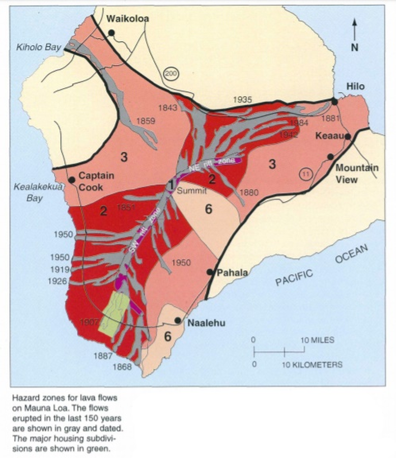
Official, Map in a booklet, long fact-sheet, or handbook
Hazard zones for lava flows on Mauna Loa
Page 28 in: U.S. Geological Survey (USGS). (1997). Volcanic and Seismic Hazards on the Island of Hawaii. U.S. Geological Survey, Unumbered Series, 48 p. https://doi.org/10.3133/7000036 (Simplified from: Wright 1992)
Official, Figure in hazard assessment
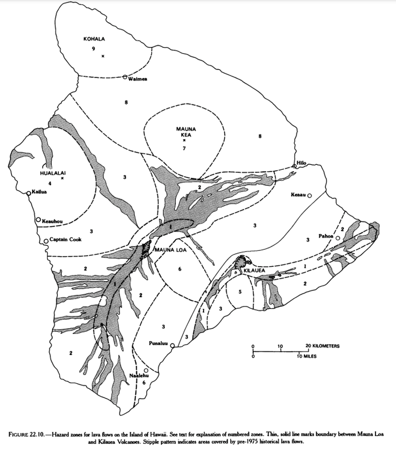
Hazard zones for lava flows on the Island of Hawaii
Figure 22.10 in: Mullineaux, D.R., Peterson, D.W., & Crandell, D.R. (1987). Volcanic hazards in the Hawaiian Islands. In: Decker, R.W., Wright, T.L., & Stauffer, P.H. (Eds.) Volcanism in Hawaii. US Geological Survey Professional Paper 1350, Chapter 22, p. 599-621. https://doi.org/10.3133/pp1350
Official, Figure in hazard assessment
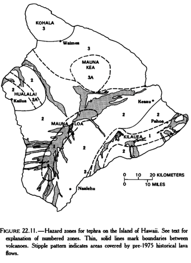
Hazard zones for tephra on the Island of Hawaii
Figure 22.11 in: Mullineaux, D.R., Peterson, D.W., & Crandell, D.R. (1987). Volcanic hazards in the Hawaiian Islands. In: Decker, R.W., Wright, T.L., & Stauffer, P.H. (Eds.) Volcanism in Hawaii. US Geological Survey Professional Paper 1350, Chapter 22, p. 599-621. https://doi.org/10.3133/pp1350
Official, Insert/poster-size map with accompanying report
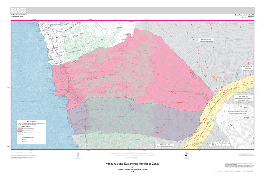
Hōnaunau and Kealakekua Inundation Zones
Sheet 9 in: Trusdell, F.A. & Zoeller, M.H. (2017). Lava inundation zone maps for Mauna Loa, Island of Hawaiʻi, Hawaii. U.S. Geological Survey, Scientific Investigations Map 3387, 12 p., 10 sheets. https://doi.org/10.3133/sim3387
Official, Unknown format
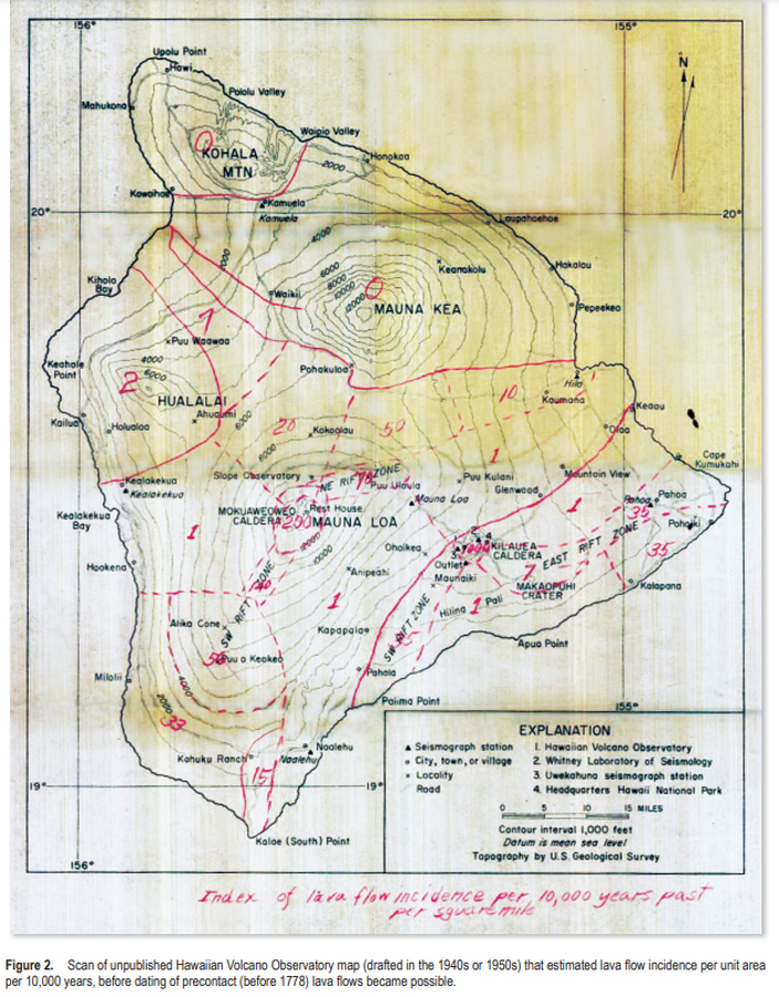
Index of lava flow incidence per 10,000 years past per square mile
Figure 2 (in reprint) in: Hawaiian Volcano Observatory. (1940s or 1950s). Index of lava flow incidence per 10,000 years past per square mile. (Reprinted in: Kauahikaua, J.P. & Tilling, R.I. (2014). Natural hazards and risk reduction in Hawai‘i. In: Poland, M.P., Takahashi, T.J., & Landowski, C.M. (eds.) Characteristics of Hawaiian Volcanoes. US Geological Survey Professional Paper 1801, p. 397-427. https://doi.org/10.3133/pp180110)
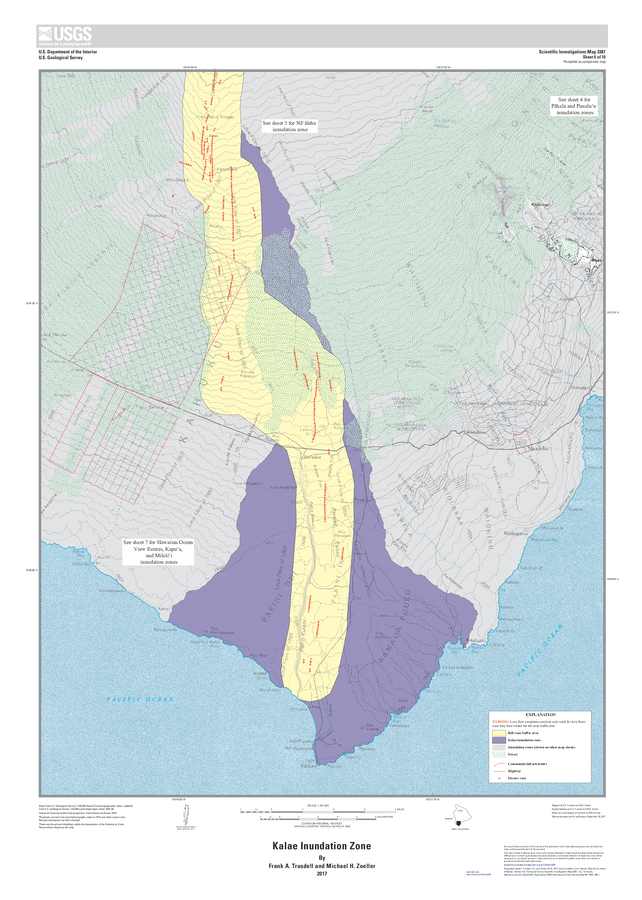
Official, Insert/poster-size map with accompanying report
Kalae Inundation Zone
Sheet 6 in: Trusdell, F.A. & Zoeller, M.H. (2017). Lava inundation zone maps for Mauna Loa, Island of Hawaiʻi, Hawaii. U.S. Geological Survey, Scientific Investigations Map 3387, 12 p., 10 sheets. https://doi.org/10.3133/sim3387
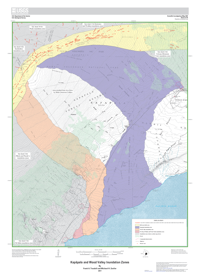
Official, Insert/poster-size map with accompanying report
Kapāpala and Wood Valley Inundation Zones
Sheet 3 in: Trusdell, F.A. & Zoeller, M.H. (2017). Lava inundation zone maps for Mauna Loa, Island of Hawaiʻi, Hawaii. U.S. Geological Survey, Scientific Investigations Map 3387, 12 p., 10 sheets. https://doi.org/10.3133/sim3387