
Advanced Search for Maps
Showing 1-10 of 11
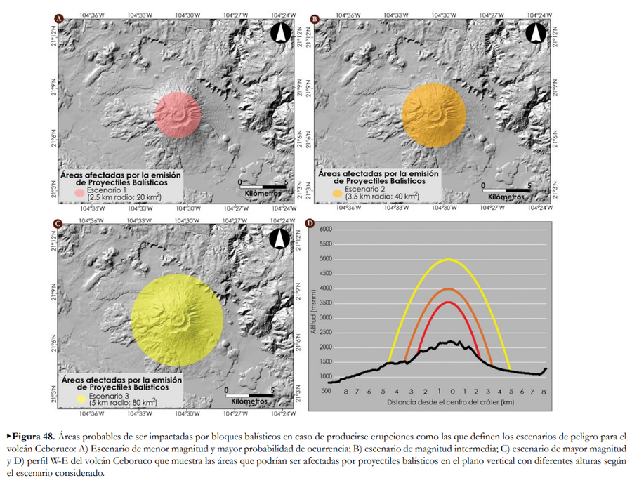
Official, Figure in hazard assessment
Áreas afectadas por la emisión de Proyectiles Balísticos
(Areas affected by the emission of Ballistic Projectiles)
Figure 48 in: Ferrés López, D., Sieron, K., González Zuccolotto, K., Constantinescu, R., Agustín Flores, J., Siebe Grabach, C., Capra Pedol, L., Connor, L., & Connor, C.B. (2019). Memoria técnica del mapa de peligros del volcán Ceboruco (Nayarit). Monografías del Instituto de Geofísica, 24.
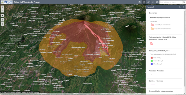
Official, Interactive web-based map
Crisis del Volcán de Fuego
(Fuego Volcano Crisis)
Instituto Nacional de Sismología, Vulcanologia, Meteorologia e Hidrología (INSIVUMEH), Map Action, Volcano Disaster Assistance Program (VDAP), U.S. Geological Survey (USGS), University of Edinburgh & Michigan Technological University. (2018). Crisis del Volcan Fuego.
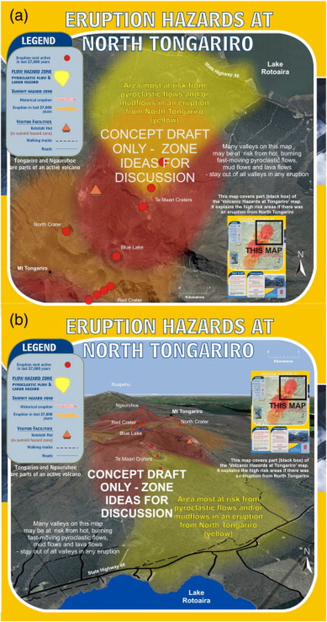
Official, Map sheet or poster
Eruption Hazards at North Tongariro
GNS Science (compiler). (2012). Te Maari Eruption Phenomena. Version 0.1, 6 August 2012. (Reprinted in: Leonard, G. S., Stewart, C., Wilson, T. M., Procter, J. N., Scott, B. J., Keys, H. J., Jolly, G.E., Wardman, J.B., Cronin. S.J. & McBride, S. K. (2014). Integrating multidisciplinary science, modelling and impact data into evolving, syn-event volcanic hazard mapping and communication: a case study from the 2012 Tongariro eruption crisis, New Zealand. Journal of Volcanology and Geothermal Research, 286, p. 208-232. https://doi.org/10.1016/j.jvolgeores.2014.08.018)
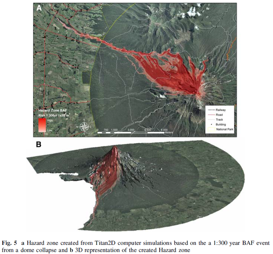
Figure in a journal article
Hazard zone created from Titan2D computer simulations based on the 1:300 year BAF event from a dome collapse and 3D representation of the created Hazard zone
Figure 5 in: Procter, J. N., Cronin, S. J., Platz, T., Patra, A., Dalbey, K., Sheridan, M., & Neall, V. (2010). Mapping block-and-ash flow hazards based on Titan 2D simulations: a case study from Mt. Taranaki, NZ. Natural Hazards, 53, 483-501.
Official, Map sheet or poster
Mapa de Peligros Volcánicos Potenciales del Volcán Guagua Pichincha - 3ra. Edición
(Map of Potential Volcanic Hazards of the Guagua Pichincha Volcano - 3rd. Edition)
IG-EPN, IGM, IRD. (2019). Mapa de Peligros Volcánicos Potenciales del Volcán Guagua Pichincha 3ra. Edición, Quito - Ecuador.
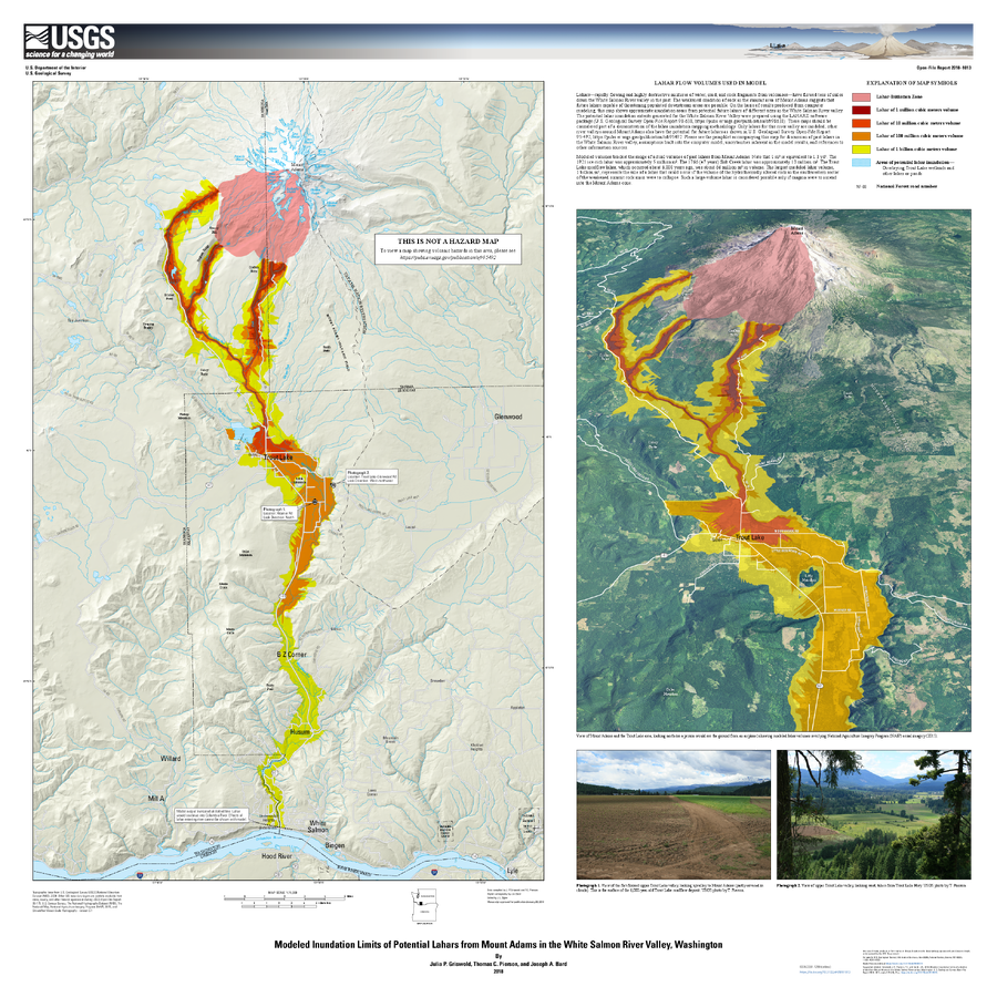
Official, Insert/poster-size map with accompanying report
Modeled Inundation Limits of Potential Lahars from Mount Adams in the White Salmon River Valley, Washington
Griswold, J.P., Pierson, T.C., and Bard J.A. (2018). Modeled inundation limits of potential lahars from Mount Adams in the White Salmon River valley, Washington. U.S. Geological Survey Open-File Report 2018–1013, scale 1:75,000, 14 p. https://doi.org/10.3133/ofr20181013
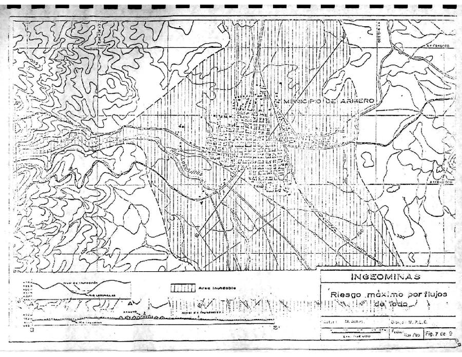
Official, Figure in hazard assessment
Riesgo máximo por flujos de lodo - Armero
(Maximum risk due to mudflows - Armero)
Figure 7 in: Instituto Colombiano de Geología y Minería (INGEOMINAS). (1985). Mapa de Riesgos Volcánicos Potenciales del Nevado del Ruiz. Texto Explicativa, 32 pp. Instituto Colombiano de Geología y Minería (INGEOMINAS). Medellin, Nov. 14/85.
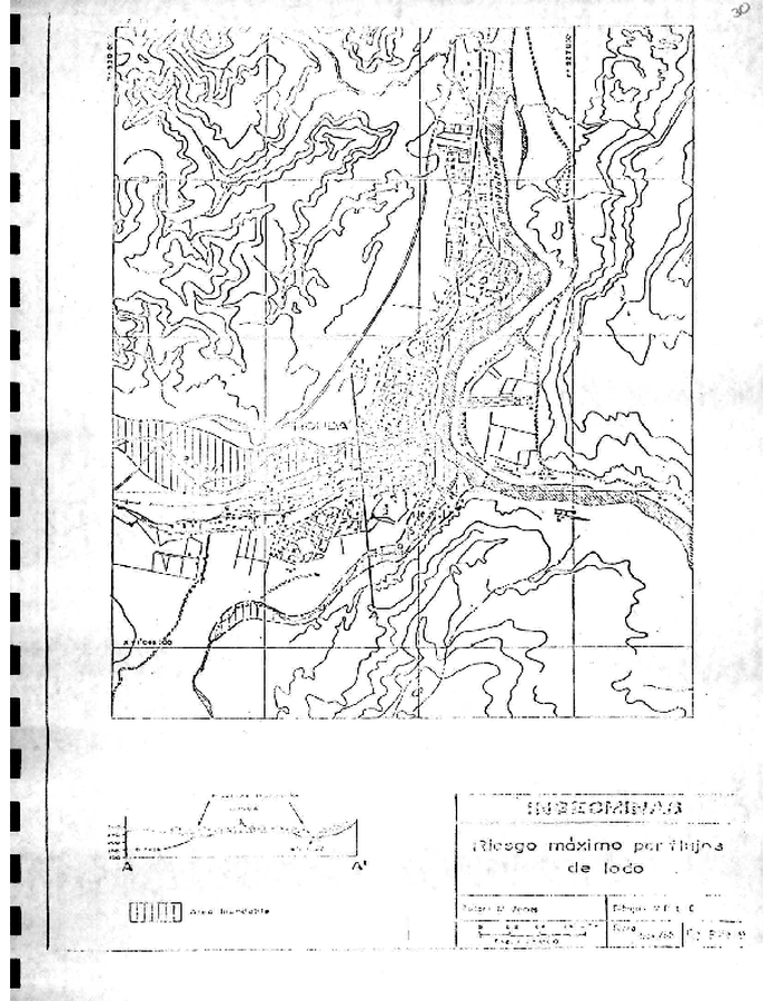
Official, Figure in hazard assessment
Riesgo máximo por flujos de lodo - Honda
(Maximum risk due to mudflows - Honda)
Figure 8 in: Instituto Colombiano de Geología y Minería (INGEOMINAS). (1985). Mapa de Riesgos Volcánicos Potenciales del Nevado del Ruiz. Texto Explicativa, 32 pp. Instituto Colombiano de Geología y Minería (INGEOMINAS). Medellin, Nov. 14/85.
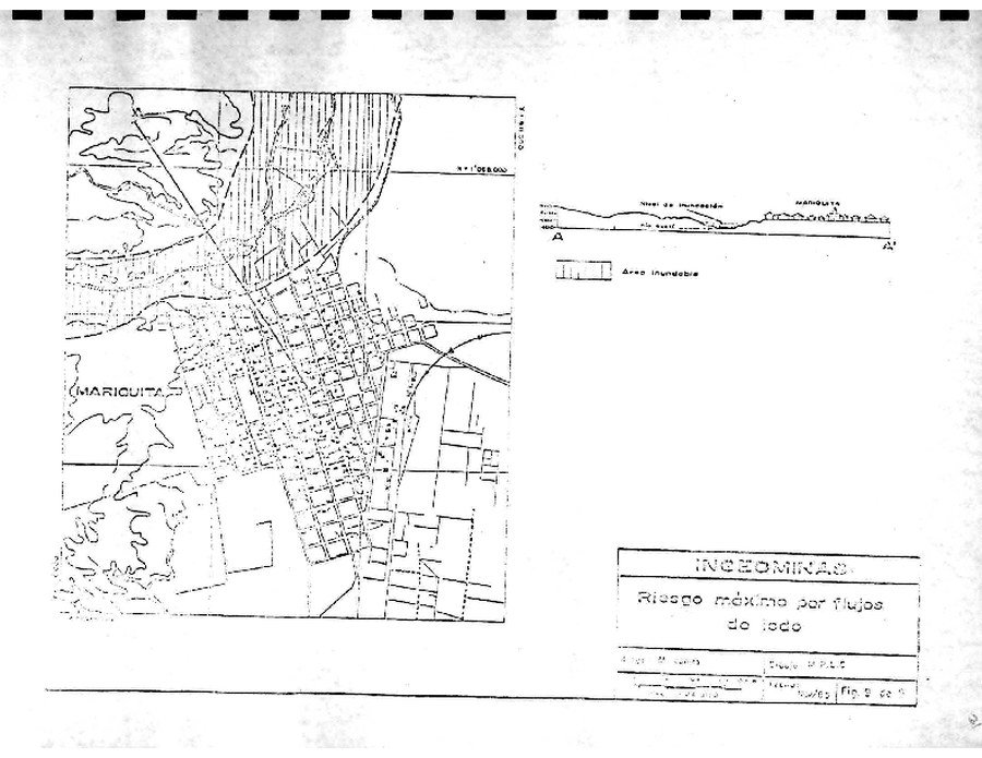
Official, Figure in hazard assessment
Riesgo máximo por flujos de lodo - Mariquita
(Maximum risk due to mudflows - Mariquita)
Figure 9 in: Instituto Colombiano de Geología y Minería (INGEOMINAS). (1985). Mapa de Riesgos Volcánicos Potenciales del Nevado del Ruiz. Texto Explicativa, 32 pp. Instituto Colombiano de Geología y Minería (INGEOMINAS). Medellin, Nov. 14/85.
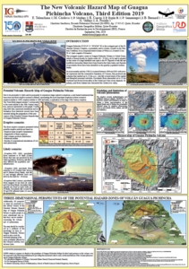
Official, Figure in a conference presentation
The New Volcanic Hazard Map of Guagua Pichincha Volcano, Third Edition 2019
Telenchana, E., Córdova, M., Mothes, P., Espín, P., Samaniego, P., Bernard, B., Vallejo, S., & Proaño A. (2019). The new potential volcanic hazard map of Guagua Pichincha Volcano, Third Edition 2019. 8th International Symposium on Andean Geodynamics (ISAG).
Page: 1 2