
Advanced Search for Maps
Showing 11-20 of 24
Official, Figure in hazard assessment
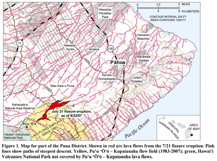
Map for part of the Puna District
Figure 1 in: Kauahikaua, J. (2007). Lava flow hazard assessment, as of August 2007, for Kīlauea east rift zone eruptions, Hawai‘i Island. U.S. Geological Survey Open-File Report 2007-1264, 9 p.
Official, Figure on website
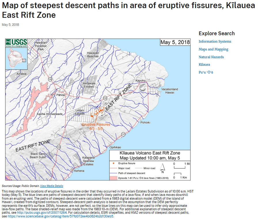
Map of steepest descent paths in area of eruptive fissures, Kīlauea East Rift Zone
U.S. Geological Survey (USGS). (2018). Map of steepest descent paths in area of eruptive fissures, Kīlauea East Rift Zone. U.S. Geological Survey. https://www.usgs.gov/maps/map-steepest-descent-paths-area-eruptive-fissures-kilauea-east-rift-zone
Official, Figure in a journal article
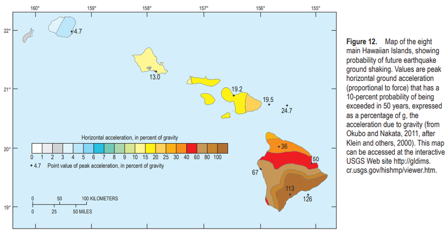
Map of the eight main Hawaiian Islands, showing probability of future earthquake ground shaking
Figure 12 in: Kauahikaua, J.P. & Tilling, R.I. (2014). Natural hazards and risk reduction in Hawai‘i. In: Poland, M.P., Takahashi, T.J., & Landowski, C.M. (eds.) Characteristics of Hawaiian Volcanoes. US Geological Survey Professional Paper 1801, p. 397-427. https://doi.org/10.3133/pp180110

Official, Figure in hazard assessment
Map of the middle east rift zone of Kilauea Volcano showing the hazard zonation of the former Campbell Estate property at Kahauale‘a, the three geothermal subzones, and the subsequent coverage by lavas from the current eruption
Figure 3 in: Kauahikaua, J. P., Moore, R. B., & Delaney, P. (1994). Volcanic activity and ground deformation hazard analysis for the Hawaii geothermal project environmental impact statement. US Geological Survey, Open File Report 94-553. 44 p. https://doi.org/10.3133/ofr94553
Official, Insert/poster-size map with accompanying report
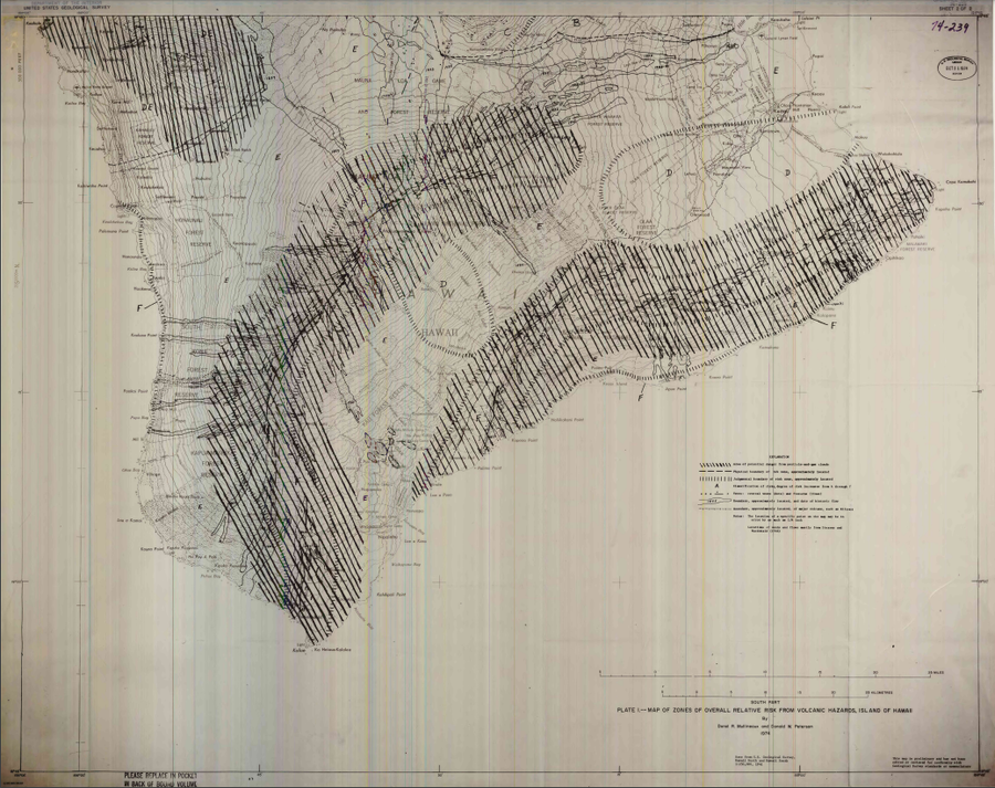
Map of Zones of Overall Relative Risk From Volcanic Hazards, Island of Hawaii
Plate 1 in: Mullineaux, D.R. & Peterson, D.W. (1974). Volcanic hazards on the Island of Hawaii. U.S. Geological Survey, Open-File Report 74-239. https://doi.org/10.3133/ofr74239
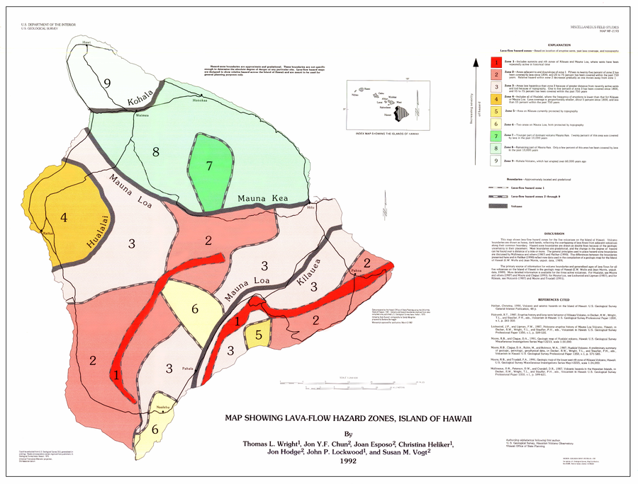
Official, Map sheet or poster
Map Showing Lava-Flow Hazard Zones, Island of Hawaii
Wright, T.L., Chun, J.Y.F., Exposo, J., Heliker, C., Hodge, J., Lockwood, J.P., & Vogt, S.M. (1992). Map showing lava-flow hazard zones, Island of Hawaii. U.S. Geological Survey, Miscellaneous Field Studies Map 2193, scale 1:250,000. https://doi.org/10.3133/mf2193
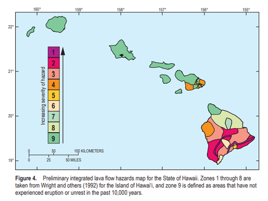
Official, Figure in a journal article
Preliminary integrated lava flow hazards map for the State of Hawaii
Figure 4 in: Kauahikaua, J.P. & Tilling, R.I. (2014). Natural hazards and risk reduction in Hawai‘i. In: Poland, M.P., Takahashi, T.J., & Landowski, C.M. (eds.) Characteristics of Hawaiian Volcanoes. US Geological Survey Professional Paper 1801, p. 397-427. https://doi.org/10.3133/pp180110
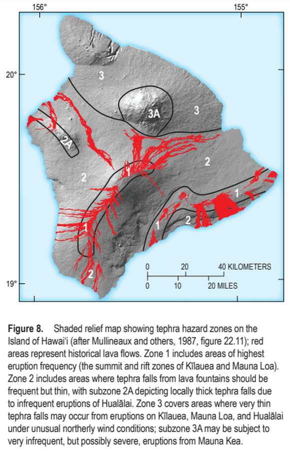
Official, Figure in a journal article
Shaded relief map showing tephra hazard zones on the Island of Hawai‘i
Figure 8 in: Kauahikaua, J.P. & Tilling, R.I. (2014). Natural hazards and risk reduction in Hawai‘i. In: Poland, M.P., Takahashi, T.J., & Landowski, C.M. (eds.) Characteristics of Hawaiian Volcanoes. US Geological Survey Professional Paper 1801, p. 397-427. https://doi.org/10.3133/pp180110
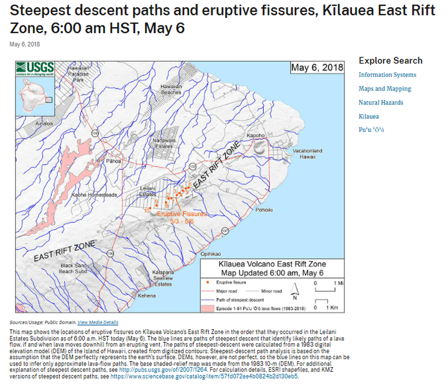
Official, Figure on website
Steepest descent paths and eruptive fissures, Kīlauea East Rift Zone, 6:00 am HST, May 6
U.S. Geological Survey (USGS). (2018). Steepest descent paths and eruptive fissures, Kīlauea East Rift Zone, 6:00 am HST, May 6. U.S. Geological Survey. https://www.usgs.gov/maps/steepest-descent-paths-and-eruptive-fissures-kilauea-east-rift-zone-600-am-hst-may-6
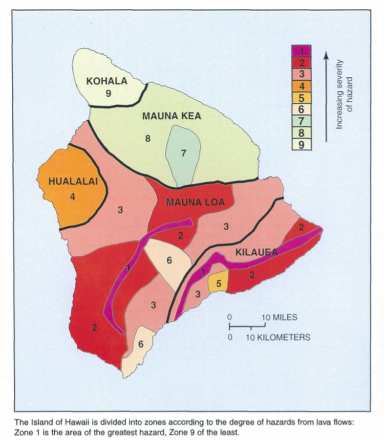
Official, Map in a booklet, long fact-sheet, or handbook
The Island of Hawaii is divided into zones according to the degree of hazards from lava flows
Page 22 in: U.S. Geological Survey (USGS). (1997). Volcanic and Seismic Hazards on the Island of Hawaii. U.S. Geological Survey, Unumbered Series, 48 p. https://doi.org/10.3133/7000036 (Simplified from: Wright 1992)