
Advanced Search for Maps
Showing 1951-1960 of 2020

Official, Insert/poster-size map with accompanying report
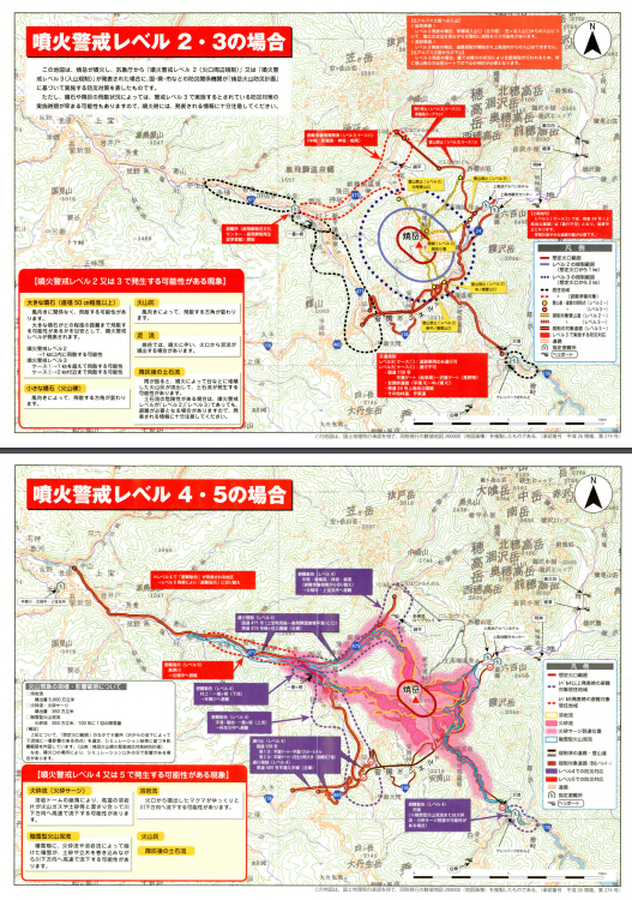
Yakedake Basic Volcano Disaster Prevention Map
Yakedake Volcano Disaster Prevention Council. (2019). Yakedake volcano disaster prevention and evacuation plan.
Official, Flyer, brochure, short fact-sheet, or handout
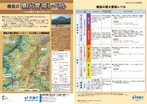
Yakedake Volcanic Alert Levels
Japan Meteorological Agency. (2020). Yakedake Volcanic Alert Levels. Volcano Monitoring and Warning Center, Volcano Division, Earthquake and Volcano Department.

Official, Flyer, brochure, short fact-sheet, or handout
Yakedake Volcano Disaster Prevention Map
Matsumoto City, Nagano Prefecture & Yakedake Volcano Eruption Countermeasure Council. (2015). Yakedake Volcano Disaster Prevention Map.
Official, Flyer, brochure, short fact-sheet, or handout
Yakedake Volcano Disaster Prevention Map
Takeyama City. (2014). Yakedake Volcano Disaster Prevention Map.

Official, Hiking or trail map
Yakedake volcano disaster prevention map (mobile version for climbers)
Gifu Prefecture Volcano Disaster Prevention Council. (2017). Yakedake Volcano Disaster Prevention Map. (waterproof hiking map).
Official, Map sheet or poster
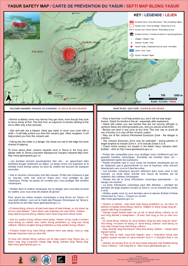
Yasur Safety Map
Vanuatu Meteorology & Geo-Hazards Department. (2016). Yasur Safety Map. Government of Vanuatu, Vanuatu Meteorology & Geo-Hazards Department, Vanuatu National Disaster Risk Management Office, New Zealand Foreign Affairs & Trade Aid Programme, GNS Science.
Official, Map sheet or poster
Yufudake/Tsurumidake/Garandake Volcano Disaster Prevention Map
Beppu City, Yufu City, Oita Prefecture, Usa City, & Hiji Town Survey. (2006). Yufudake/Tsurumidake/Garandake Volcano Disaster Prevention Map.
Official, Flyer, brochure, short fact-sheet, or handout
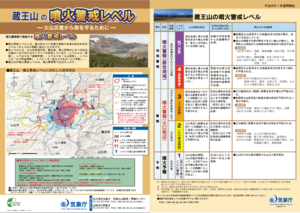
Zaozan Volcanic Alert Levels
Japan Meteorological Agency. (2016). Zaozan Volcanic Alert Levels. Volcano Monitoring and Warning Center, Volcano Division, Earthquake and Volcano Department.
Official, Map in an information statement
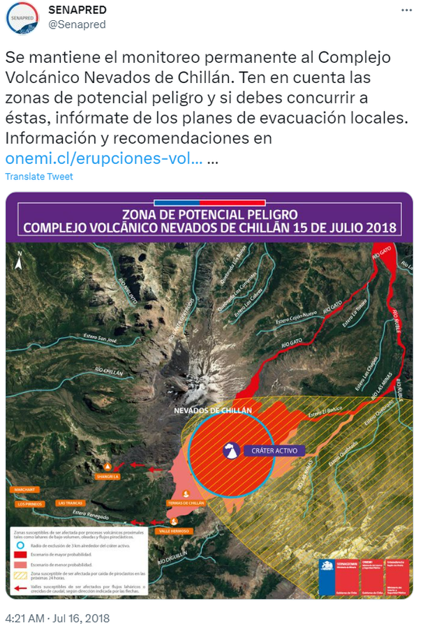
Zona de Potencial Peligro Complejo Volcánico Nevados de Chillán 15 de Julio 2018
(Potential Hazard Zone Nevados de Chillán Volcanic Complex July 15, 2018)
Servicio Nacional de Geología y Minería (SERNAGEOMIN) & Oficina Nacional de Emergencia del Ministerio del Interior y Seguridad Pública (ONEMI). (2018). Zona de Potencial Peligro Complejo Volcánico Nevados de Chillán 15 de Julio 2018. Twitter. https://twitter.com/Senapred/status/1018817975573450752
Official, Map in an information statement
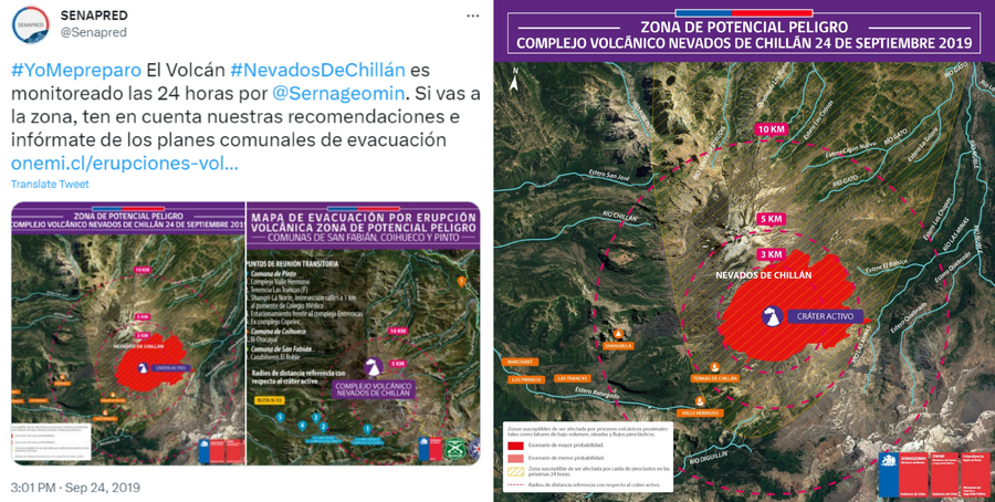
Zona de Potencial Peligro Complejo Volcánico Nevados de Chillán 24 de Septiembre 2019
(Potential Hazard Zone Nevados de Chillán Volcanic Complex September 24, 2019)
Servicio Nacional de Geología y Minería (SERNAGEOMIN) & Oficina Nacional de Emergencia del Ministerio del Interior y Seguridad Pública (ONEMI). (2019). Zona de Potencial Peligro Complejo Volcánico Nevados de Chillán 24 de Septiembre 2019. Twitter. https://twitter.com/Senapred/status/1176617555206823941