
Advanced Search for Maps
Showing 2161-2170 of 2217
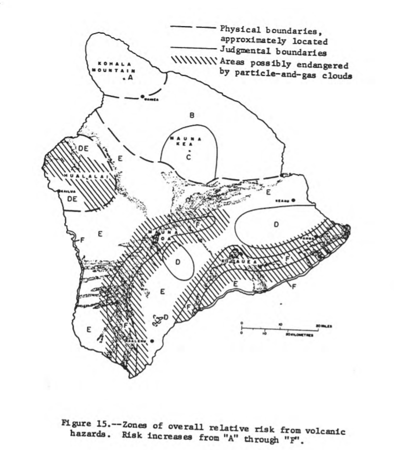
Official, Figure in hazard assessment
Zones of overall relative risk from volcanic hazards. Risk increases from "A" through "F"
Figure 15 in: Mullineaux, D.R. & Peterson, D.W. (1974). Volcanic hazards on the Island of Hawaii. U.S. Geological Survey, Open-File Report 74-239. https://doi.org/10.3133/ofr74239
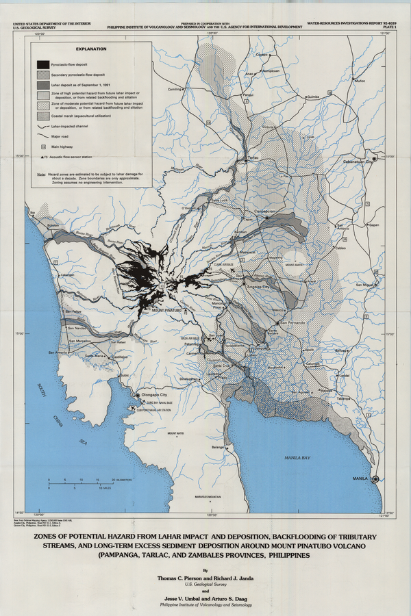
Official (foreign agency), Insert/poster-size map with accompanying report
Zones of Potential Hazard from Lahar Impact and Deposition, Backflooding of Tributary Streams, and Long-Term Excess Sediment Deposition Around Mount Pinatubo Volcano (Pampanga, Tarlac, and Zambales Provinces, Philippines)
Plate 1 in: Pierson, T.C., Janda, R.J., Umbal, J.V., & Daag, A.S. (1992). Immediate and long-term hazards from lahars and excess sedimentation in rivers draining Mount Pinatubo, Philippines. U.S. Geological Survey, Water-Resources Investigations Report 92-4039, 35 p., 1 plate. https://doi.org/10.3133/wri924039
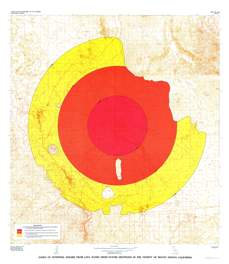
Official, Insert/poster-size map with accompanying report
Zones of Potential Hazard from Lava Flows from Future Eruptions in the Vicinity of Mount Shasta, California
Plate 2 in: Miller, C.D. (1980). Potential hazards from future eruptions in the vicinity of Mount Shasta Volcano, Northern California. U.S. Geological Survey, Bulletin 1503, 43 p., 3 plates. https://doi.org/10.3133/b1503

Official, Insert/poster-size map with accompanying report
Zones of Potential Hazard from Pyroclastic Flows and Associated Ash Clouds and Mudflows that may Result from future eruptions in the vicinity of Mount Shasta, California
Plate 3 in: Miller, C.D. (1980). Potential hazards from future eruptions in the vicinity of Mount Shasta Volcano, Northern California. U.S. Geological Survey, Bulletin 1503, 43 p., 3 plates. https://doi.org/10.3133/b1503
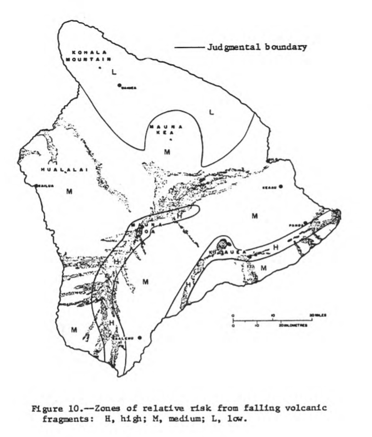
Official, Figure in hazard assessment
Zones of relative risk from falling volcanic fragments
Figure 10 in: Mullineaux, D.R. & Peterson, D.W. (1974). Volcanic hazards on the Island of Hawaii. U.S. Geological Survey, Open-File Report 74-239. https://doi.org/10.3133/ofr74239

Official, Figure in hazard assessment
Zones of relative risk from lateral blasts
Figure 3 in: Crandell, D. R. (1975). Assessment of volcanic risk on the island of Oahu, Hawaii. U.S. Geological Survey, Open-File Report 75-287. https://doi.org/10.3133/ofr75287

Official, Figure in hazard assessment
Zones of relative risk from lava flows
Figure 4 in: Crandell, D. R. (1975). Assessment of volcanic risk on the island of Oahu, Hawaii. U.S. Geological Survey, Open-File Report 75-287. https://doi.org/10.3133/ofr75287

Official, Figure in hazard assessment
Zones of relative risk from lava-flow burial
Figure 9 in: Mullineaux, D.R. & Peterson, D.W. (1974). Volcanic hazards on the Island of Hawaii. U.S. Geological Survey, Open-File Report 74-239. https://doi.org/10.3133/ofr74239
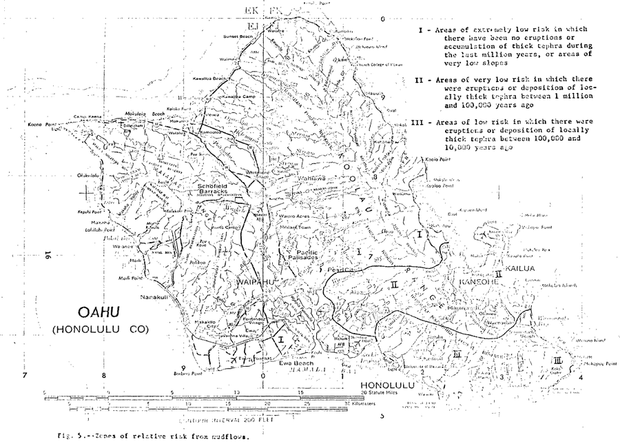
Official, Figure in hazard assessment
Zones of relative risk from mudflows
Figure 5 in: Crandell, D. R. (1975). Assessment of volcanic risk on the island of Oahu, Hawaii. U.S. Geological Survey, Open-File Report 75-287. https://doi.org/10.3133/ofr75287
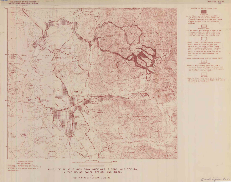
Official, Insert/poster-size map with accompanying report
Zones of relative risk from mudflows, floods, and tephra, in the Mount Baker region, Washington
Plate 1 in: Hyde, J.H. & Crandell, D.R. (1975). Origin and age of postglacial deposits and assessment of potential hazards from future eruptions of Mount Baker, Washington. U.S. Geological Survey, Open-File Report 75-286, 22 p. https://doi.org/10.3133/ofr75286