
Advanced Search for Maps
Showing 21-30 of 88
Eldey, Iceland
Official, Interactive web-based map
Eldey, possible range of isopachs based on submarine eruptions on Reykjanes volcanic system (cm) - After Jakobsson S.P. (Unpublished material)
Larsen, G. (2019). Eldey. In: Oladottir, B., Larsen, G. & Guðmundsson, M. T. Catalogue of Icelandic Volcanoes. Iceland Meteorological Office (IMO), Univeristy of Iceland, and Civil Protection Department of the National Commissioner of the Iceland Police (CPD-NCIP). (Simplified from: S.P. Jakobsson Unpublished data)
Official, Interactive web-based map
Eldey, possible range of isopachs based on submarine eruptions on Reykjanes volcanic system (cm) - After Jakobsson S.P. (Unpublished material)
Larsen, G. (2019). Eldey. In: Oladottir, B., Larsen, G. & Guðmundsson, M. T. Catalogue of Icelandic Volcanoes. Iceland Meteorological Office (IMO), Univeristy of Iceland, and Civil Protection Department of the National Commissioner of the Iceland Police (CPD-NCIP). (Simplified from: S.P. Jakobsson Unpublished data)

Figure in a journal article
Estimated Travel Time of Mudflows at Mount Hood, Oregon
Preppernau, C. A., & Jenny, B. (2016). Estimated travel time of mudflows at Mount Hood, Oregon. Journal of Maps, 12(5), p. 711-715. https://doi.org/10.1080/17445647.2015.1120244
Official, Figure in hazard assessment
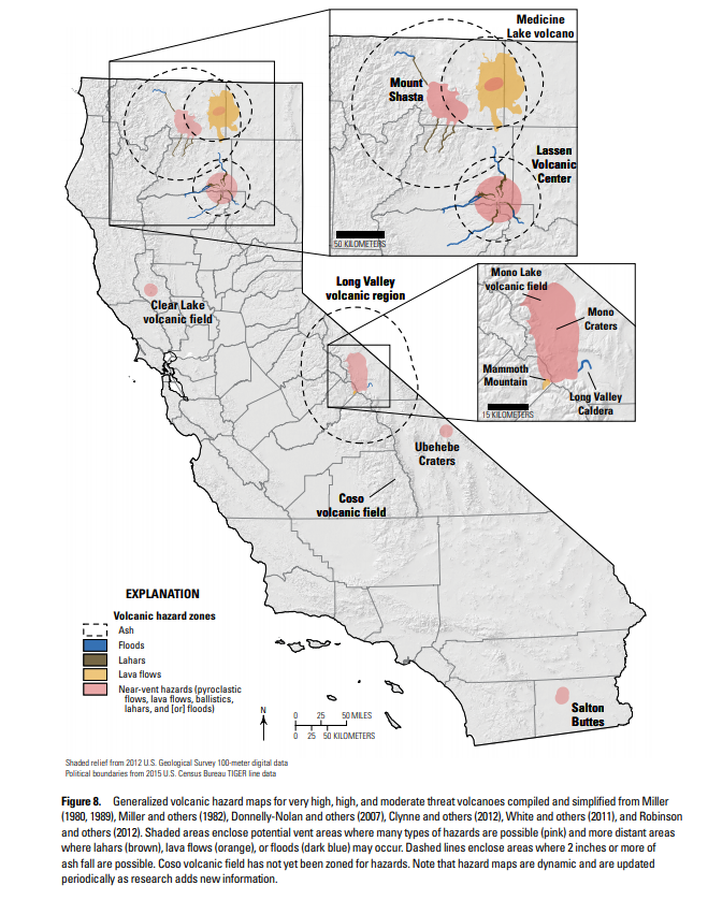
Generalized volcanic hazard maps for very high, high, and moderate threat volcanoes compiled and simplified from Miller (1980, 1989), Miller and others (1982), Donnelly-Nolan and others (2007), Clynne and others (2012), White and others (2011), and Robinson and others (2012)
Figure 8 in: Mangan, M., Ball, J., Wood, N., Jones, J.L., Peters, J., Abdollahian, N., Dinitz, L., Blankenheim, S., Fenton, J., & Pridmore, C. (2019). California’s exposure to volcanic hazards. U.S. Geological Survey Scientific Investigations Report 2018–5159, v. 1.1, 49 p. https://doi.org/10.3133/sir20185159
Official, Figure on website
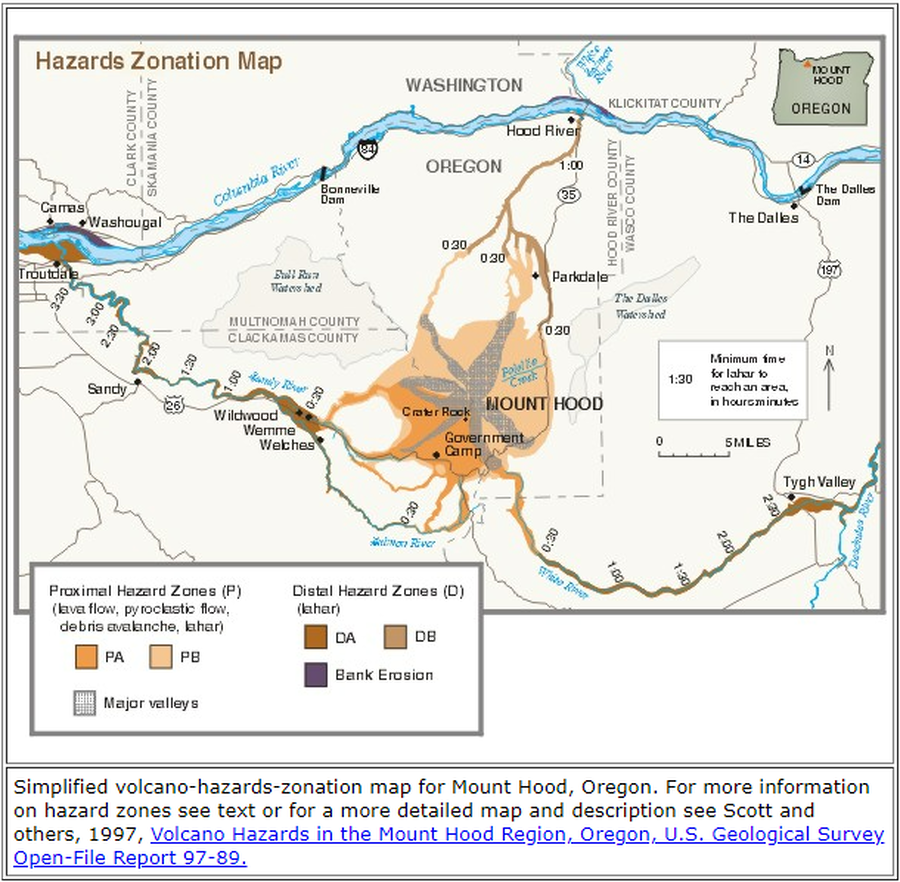
Hazards Zonation Map
Gardner, C.A., Scott, W.E., Major, J.J., & Pierson, T.C. (2000). Hazards Zonation Map. Mount Hood—History and Hazards of Oregon's Most Recently Active Volcano. U.S. Geological Survey, Fact Sheet 060-00 (Online Version 1.0). https://doi.org/10.3133/fs06000
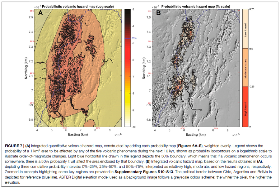
Figure in a journal article
Integrated quantitative volcanic hazard map, constructed by adding each probability map (Figures 6A–E), weighted evenly
Figure 7 in: Bertin, D., Lindsay, J.M., Cronin, S.J., de Silva, S.L., Connor, C.B., Caffe, P.J., Grosse, P., Báez, W., Bustos, E., & Constantinescu, R. (2022). Probabilistic Volcanic Hazard Assessment of the 22.5–28° S Segment of the Central Volcanic Zone of the Andes. Frontiers in Earth Science, 10. https://doi.org/10.3389/feart.2022.875439
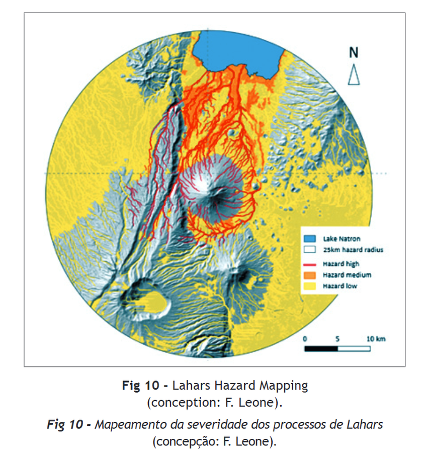
Figure in a journal article
Lahars Hazard Mapping
Figure 10 in: Rey, T., Leone, F., Defossez, S., Gherardi, M., & Parat, F. (2021). Volcanic hazards assessment of Ol Doinyo Lengai in a data scarcity context (Tanzania). Territorium, (28 (II)), 69-81.
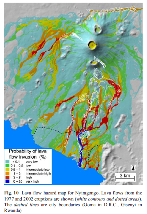
Figure in a journal article
Lava flow hazard map for Nyiragongo
Figure 10 in: Favalli, M., Chirico, G. D., Papale, P., Pareschi, M. T., & Boschi, E. (2009). Lava flow hazard at Nyiragongo volcano, DRC. Bulletin of volcanology, 71(4), p. 363-374. https://doi.org/10.1007/s00445-008-0233-y
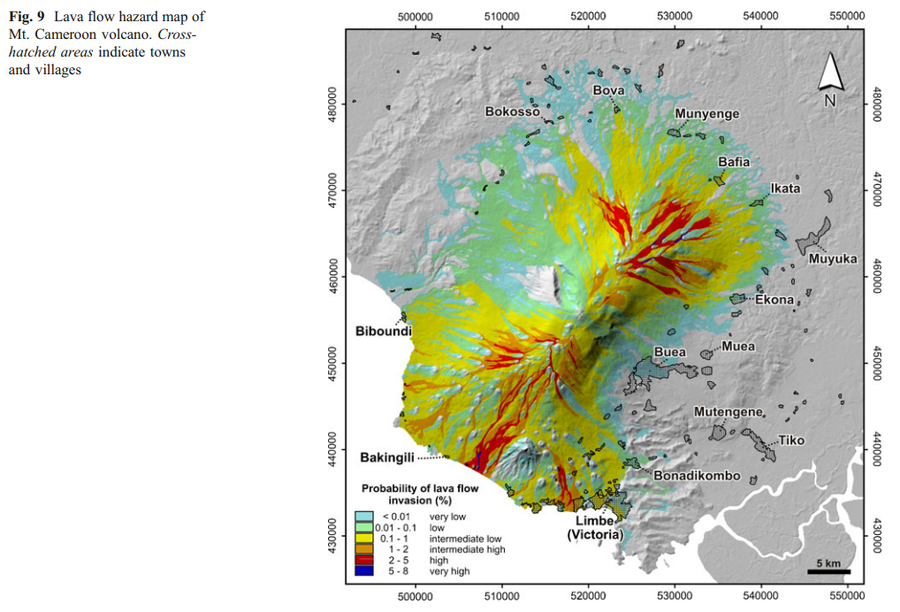
Figure in a journal article
Lava flow hazard map of Mt. Cameroon volcano
Figure 9 in: Favalli, M., Tarquini, S., Papale, P., Fornaciai, A., & Boschi, E. (2012). Lava flow hazard and risk at Mt. Cameroon volcano. Bulletin of Volcanology, 74(2), 423-439. https://doi.org/10.1007/s00445-011-0540-6
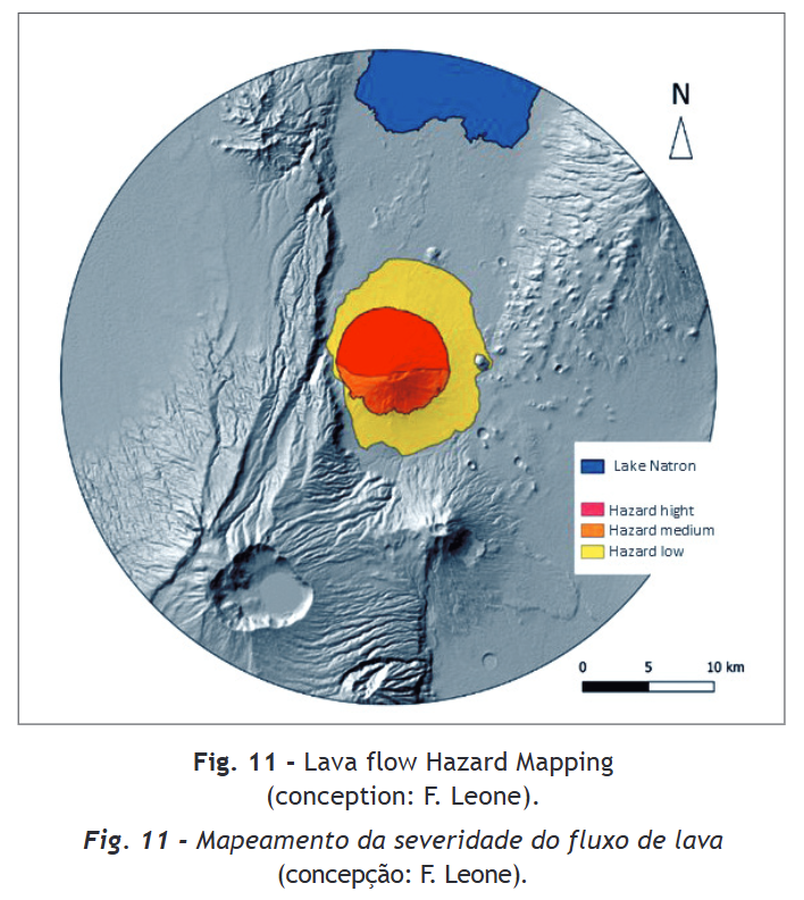
Figure in a journal article
Lava flow Hazard Mapping
Figure 11 in: Rey, T., Leone, F., Defossez, S., Gherardi, M., & Parat, F. (2021). Volcanic hazards assessment of Ol Doinyo Lengai in a data scarcity context (Tanzania). Territorium, (28 (II)), 69-81.
Official, Figure in hazard assessment
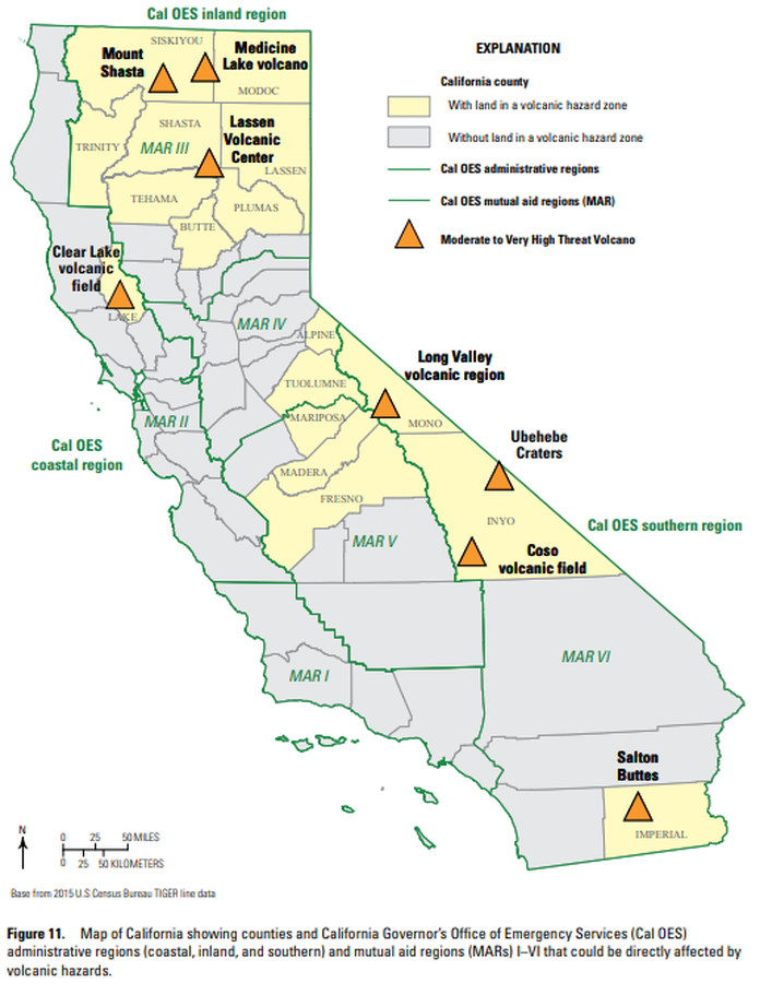
Map of California showing counties and California Governor’s Office of Emergency Services (Cal OES) administrative regions (coastal, inland, and southern) and mutual aid regions (MARs) I–VI that could be directly affected by volcanic hazards.
Figure 11 in: Mangan, M., Ball, J., Wood, N., Jones, J.L., Peters, J., Abdollahian, N., Dinitz, L., Blankenheim, S., Fenton, J., & Pridmore, C. (2019). California’s exposure to volcanic hazards. U.S. Geological Survey Scientific Investigations Report 2018–5159, v. 1.1, 49 p. https://doi.org/10.3133/sir20185159