
Advanced Search for Maps
Showing 51-60 of 1482
Official, Figure in hazard assessment
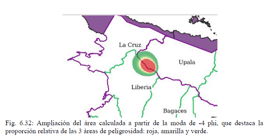
Ampliación del área calculada a partir de la moda de -4 phi, que destaca la proporción relativa de las 3 áreas de peligrosidad: roja, amarilla y verde
(Magnification of the area calculated from the -4 phi mode, highlighting the relative proportion of the 3 hazard areas: red, yellow and green)
Figure 6.32 in: Alvarado, G.E., Brenes-André, J., Venegas, L., Alpízar, Y., Núñez, S., Sánchez, M., Abarca, K., Abarca, J., Báez, W.A., Sibaja, J.P., Esquivel, L., & Arcia, T. (2022). Análisis del Peligro Volcánico del Rincón de la Vieja, Costa Rica. Instituto Costarricense de Electricidad (ICE). Setiembre 2022.
Official, Figure in a journal article
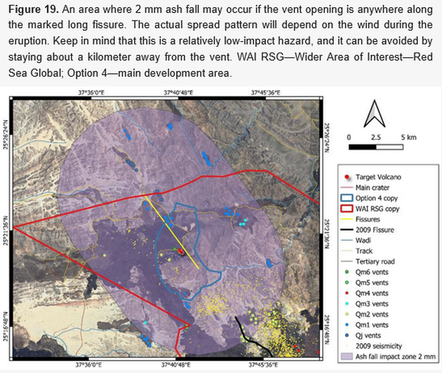
An area where 2 mm ash fall may occur if the vent opening is anywhere along the marked long fissure
Figure 19 in: Németh, K., Sowaigh, A., Ashor, M., Toni, M., & Sokolov, V. (2026). Volcanic Hazard Assessment of a Monogenetic Volcanic Field with Sporadic and Limited Information: Deterministic Approach for Harrat Lunayyir, Saudi Arabia. GeoHazards, 7(1), 33. https://doi.org/10.3390/geohazards7010033
Official, Figure in a journal article
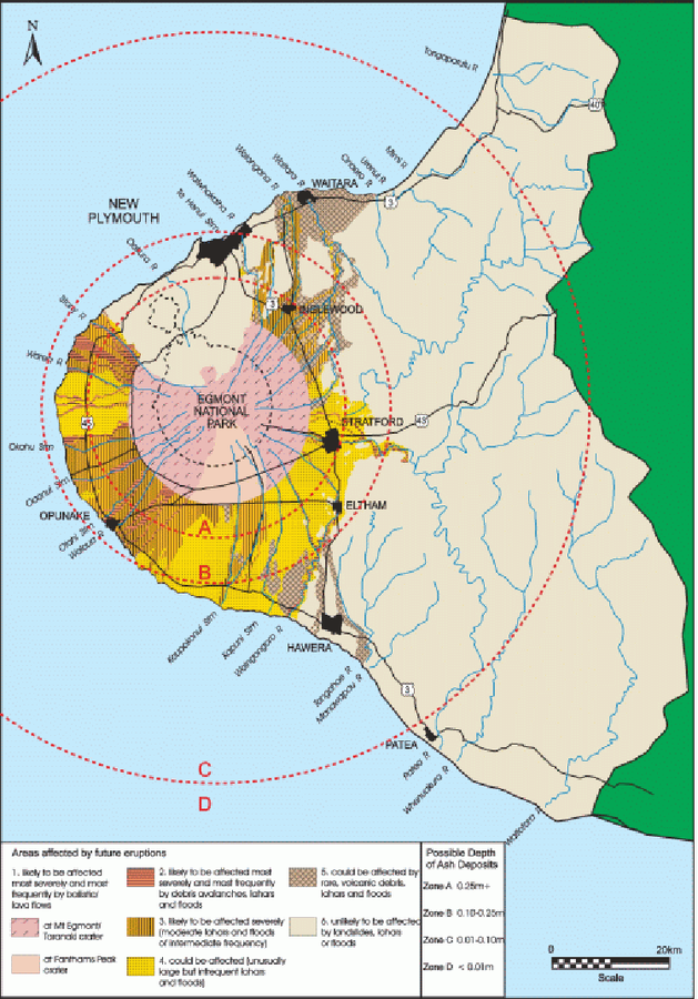
An example of a volcanic hazard map for Mount Taranaki
Figure 2 in: Becker, J.S., Saunders, W.S.A., Robertson, C.M., Leonard, G.S., & Johnston, D.M. (2010). A synthesis of challenges and opportunities for reducing volcanic risk through land use planning in New Zealand. The Australasian Journal of Disaster and Trauma Studies, 2010-1. (Simplified from: Taranaki Regional Council 2004)
Official, Figure in a journal article
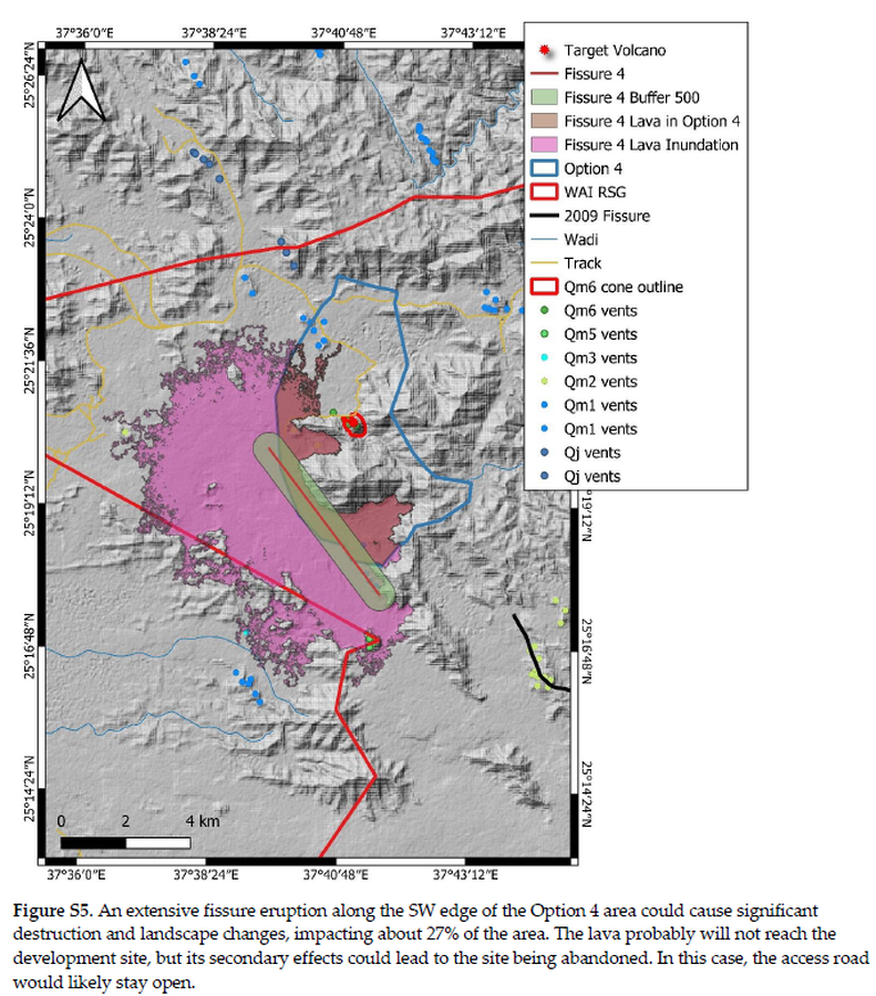
An extensive fissure eruption along the SW edge of the Option 4 area could cause significant destruction and landscape changes
Figure S5 in: Németh, K., Sowaigh, A., Ashor, M., Toni, M., & Sokolov, V. (2026). Volcanic Hazard Assessment of a Monogenetic Volcanic Field with Sporadic and Limited Information: Deterministic Approach for Harrat Lunayyir, Saudi Arabia. GeoHazards, 7(1), 33. https://doi.org/10.3390/geohazards7010033
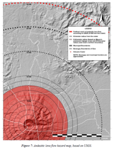
Figure in a thesis or dissertation
Andesitic lava flow hazard map
Figure 7 in: Daita, T.J.E. (2020). Preliminary Volcanic Hazard Assessment of Goa, Camarines Sur, Philippines. Thesis, Partido State University, Goa, Camarines Sur, Philippines.
Official, Figure in hazard assessment
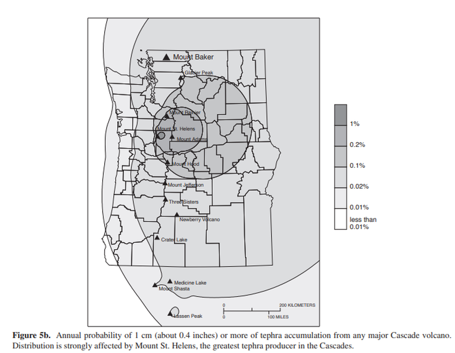
Annual probability of 1 cm (about 0.4 inches) or more of tephra accumulation from any major Cascade volcano
Figure 5b in: Gardner, C.A., Scott, K.M., Miller, C.D., Myers, B., Hildreth, W., & Pringle, P.T. (1995). Potential volcanic hazards from future activity of Mount Baker, Washington. U.S. Geological Survey, Open-File Report 95-498, 16 p., 1 plate, scale 1:100,000. https://doi.org/10.3133/ofr95498
Official, Figure in hazard assessment
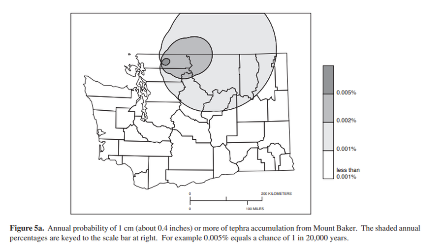
Annual probability of 1 cm (about 0.4 inches) or more of tephra from Mount Baker.
Figure 5a in: Gardner, C.A., Scott, K.M., Miller, C.D., Myers, B., Hildreth, W., & Pringle, P.T. (1995). Potential volcanic hazards from future activity of Mount Baker, Washington. U.S. Geological Survey, Open-File Report 95-498, 16 p., 1 plate, scale 1:100,000. https://doi.org/10.3133/ofr95498
Official, Figure in hazard assessment
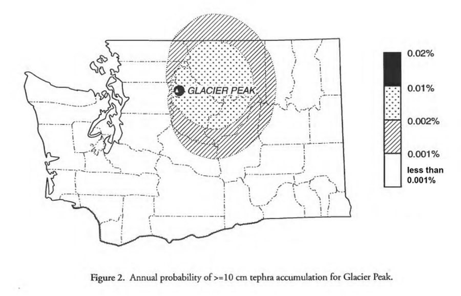
Annual probability of >=10 cm tephra accumulation for Glacier Peak
Figure 2 in: Waitt, R.B., Mastin, L.G., & Begét, J.E. (1995). Volcanic-Hazard Zonation for Glacier Peak Volcano, Washington. U.S. Geological Survey, Open-File Report 95-499, 9 p., 1 plate. https://doi.org/10.3133/ofr95499
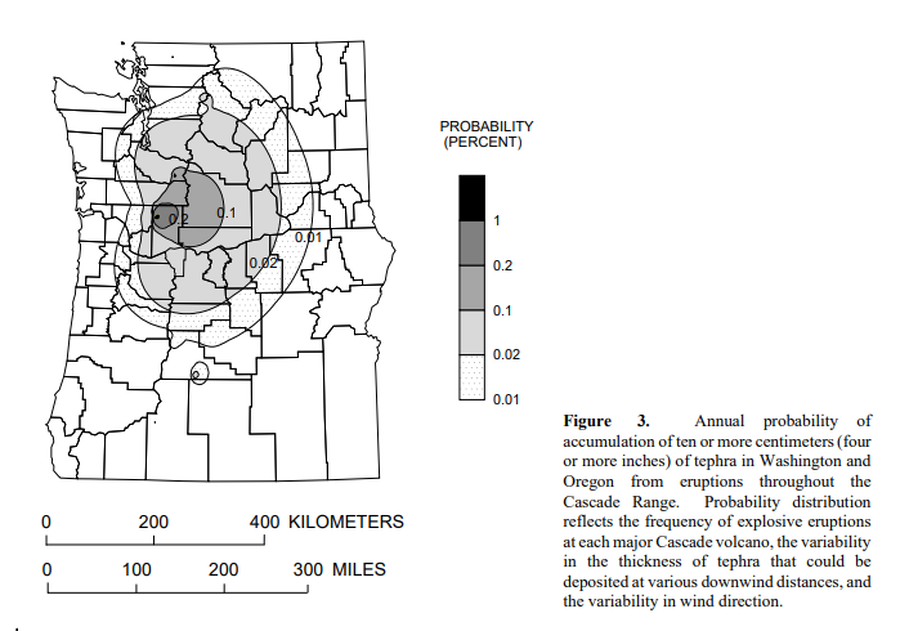
Official, Figure in hazard assessment
Annual probability of accumulation of ten or more centimeters (four or more inches) of tephra in Washington and Oregon from eruptions throughout the Cascade Range.
Figure 3 in: Wolfe, E.W. & Pierson, T.C. (1995). Volcanic-Hazard Zonation for Mount St. Helens, Washington, 1995. U.S. Geological Survey, Open-File Report 95-497, 12 p., 1 plate. https://doi.org/10.3133/ofr95497
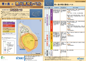
Official, Flyer, brochure, short fact-sheet, or handout
Aogashima Volcanic Alert Levels
Japan Meteorological Agency. (2018). Aogashima Volcanic Alert Levels. Volcano Monitoring and Warning Center, Volcano Division, Earthquake and Volcano Department.