
Andesitic lava flow hazard map
Isarog, Philippines, 2020
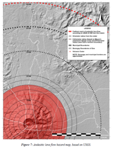
Figure 7 in: Daita, T.J.E. (2020). Preliminary Volcanic Hazard Assessment of Goa, Camarines Sur, Philippines. Thesis, Partido State University, Goa, Camarines Sur, Philippines.
This hazard map is the result of scientific research and was published in academic literature.
It is presented here to serve as an example of the map type or the map-making methodology. It is NOT the official, operational map. For the current operational hazard map, please consult the proper institutional authorities.
Map Set
- Ballistic projectile hazard map
- Ash fall hazard map with Amihan as the prevailing wind
- Ash fall hazard map with the easterlies as the prevailing wind
- Ash fall hazard map with Habagat as the prevailing wind
- Lahar hazard map of Goa, Camarines Sur
- Pyroclastic density current (PDC) hazard map of Goa, Camarines Sur