
Advanced Search for Maps
Showing 51-60 of 141
Official, Map sheet or poster
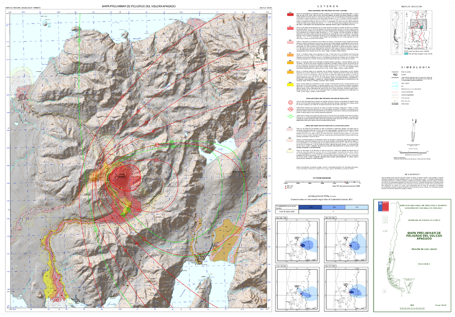
Mapa Preliminar de Peligros del Volcán Apagado
(Preliminary Hazard Map of Apagado Volcano)
Mella, M (2013). Mapa Preliminar de Peligros del Volcán Apagado, Región de los Lagos. Servicio Nacional de Geología y Minería (SERNAGEOMIN), mapa escala 1:50,000. Santiago.
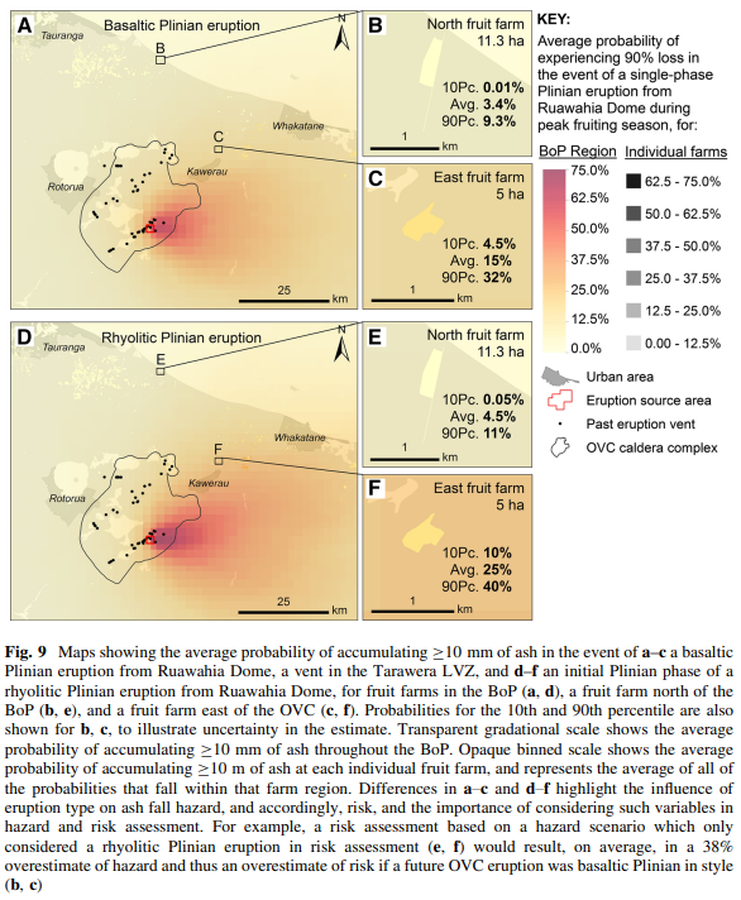
Figure in a journal article
Maps showing the average probability of accumulating ≥10 mm of ash in the event of a–c a basaltic Plinian eruption from Ruawahia Dome, a vent in the Tarawera LVZ, and d–f an initial Plinian phase of a rhyolitic Plinian eruption from Ruawahia Dome, for fruit farms in the BoP
Figure 9 in: Thompson, M. A., Lindsay, J. M., Wilson, T. M., Biass, S., & Sandri, L. (2017). Quantifying risk to agriculture from volcanic ashfall: a case study from the Bay of Plenty, New Zealand. Natural Hazards, 86(1), 31-56. https://doi.org/10.1007/s11069-016-2672-7
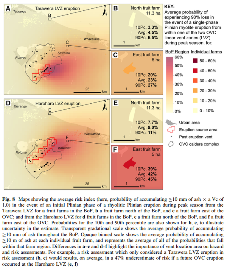
Figure in a journal article
Maps showing the average risk index (here, probability of accumulating ≥10 mm of ash × a Vc of 1.0) in the event of an initial Plinian phase of a rhyolitic Plinian eruption during peak season from the Tarawera LVZ for a fruit farms in the BoP
Figure 8 in: Thompson, M. A., Lindsay, J. M., Wilson, T. M., Biass, S., & Sandri, L. (2017). Quantifying risk to agriculture from volcanic ashfall: a case study from the Bay of Plenty, New Zealand. Natural Hazards, 86(1), 31-56. https://doi.org/10.1007/s11069-016-2672-7
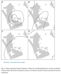
Figure in a journal article
Mean simulated tephra thickness within the Auckland Region
Figure 6 in: Magill, C. R., Hurst, A. W., Hunter, L. J., & Blong, R. J. (2006). Probabilistic tephra fall simulation for the Auckland Region, New Zealand. Journal of volcanology and geothermal research, 153(3-4), 370-386. https://doi.org/10.1016/j.jvolgeores.2005.12.002
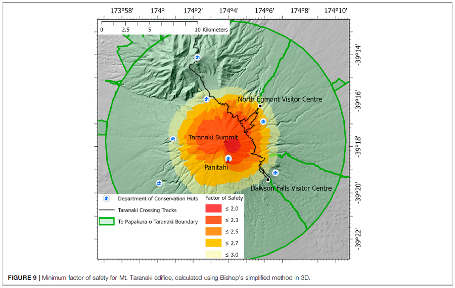
Figure in a journal article
Minimum factor of safety for Mt. Taranaki edifice
Figure 9 in: Mead, S., Procter, J., Bebbington, M., & Rodriguez-Gomez, C. (2022). Probabilistic Volcanic Hazard Assessment for National Park Infrastructure Proximal to Taranaki Volcano (New Zealand). Frontiers in Earth Science, 435. https://doi.org/10.3389/feart.2022.832531

Official, Map sheet or poster
Mt. Iwate Volcanic Disaster Prevention Map
The Counter-measures Investigation Committee on Volcanic Disasters at Mt. Iwate. (1998). Mt. Iwate Volcanic Disaster Prevention Map.
Official, Map sheet or poster
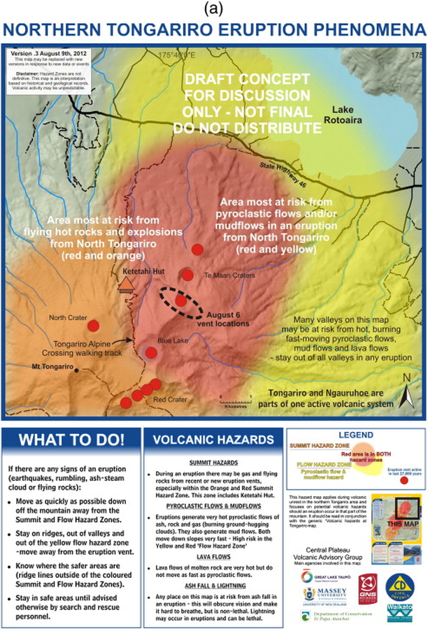
Northern Tongariro Eruption Phenomena
GNS Science (compiler). (2012). Te Maari Eruption Phenomena. Version 0.3, 9 August 2012. (Reprinted in: Leonard, G. S., Stewart, C., Wilson, T. M., Procter, J. N., Scott, B. J., Keys, H. J., Jolly, G.E., Wardman, J.B., Cronin. S.J. & McBride, S. K. (2014). Integrating multidisciplinary science, modelling and impact data into evolving, syn-event volcanic hazard mapping and communication: a case study from the 2012 Tongariro eruption crisis, New Zealand. Journal of Volcanology and Geothermal Research, 286, p. 208-232. https://doi.org/10.1016/j.jvolgeores.2014.08.018)
Official, Map sheet or poster
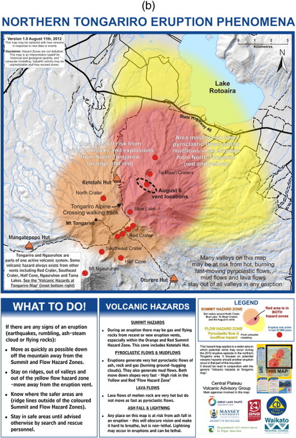
Northern Tongariro Eruption Phenomena
GNS Science (compiler). (2012). Te Maari Eruption Phenomena. Version 1.0, 11 August 2012. (Reprinted in: Leonard, G. S., Stewart, C., Wilson, T. M., Procter, J. N., Scott, B. J., Keys, H. J., Jolly, G.E., Wardman, J.B., Cronin. S.J. & McBride, S. K. (2014). Integrating multidisciplinary science, modelling and impact data into evolving, syn-event volcanic hazard mapping and communication: a case study from the 2012 Tongariro eruption crisis, New Zealand. Journal of Volcanology and Geothermal Research, 286, p. 208-232. https://doi.org/10.1016/j.jvolgeores.2014.08.018)
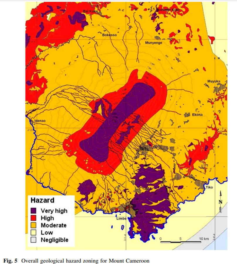
Figure in a journal article
Overall geological hazard zoning for Mount Cameroon
Figure 5 in: Thierry, P., Stieltjes, L., Kouokam, E., Nguéya, P., & Salley, P. M. (2008). Multi-hazard risk mapping and assessment on an active volcano: the GRINP project at Mount Cameroon. Natural Hazards, 45(3), 429-456. https://doi.org/10.1007/s11069-007-9177-3
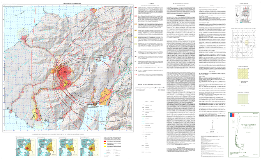
Official, Map sheet or poster
Peligros del Volcán Apagado
(Hazards of Apagado Volcano)
Mella, M. (2016). Peligros del Volcán Apagado, Región de Los Lagos. Servicio Nacional de Geología y Minería (SERNAGEOMIN), Carta Geológica de Chile, Serie Geología Ambiental 26, mapa escala 1:50.000. Santiago.