
Advanced Search for Maps
Showing 11-20 of 37
Soufrière St. Vincent, Saint Vincent and the Grenadines
Official, Figure on website
Georgetown Community Multi-Hazard Map
The University of the West Indies Seismic Research Centre (UWI-SRC) and National Emergency Management Organization (NEMO). (2021). Georgetown Community Multi-Hazard Map. https://uwiseismic.com/wp-content/uploads/2021/10/Georgetown-Hazard-Map-scaled.jpg
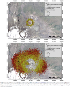
Figure in a journal article
Impact crater distributions from possible future eruption scenarios modelled using the Tsunematsu et al. (2013) ballistic trajectory model
Figure 11 in: Fitzgerald, R. H., Tsunematsu, K., Kennedy, B. M., Breard, E. C. P., Lube, G., Wilson, T. M., Jolly, A.D., Pawson, J., Rosenburg, M.D., & Cronin, S. J. (2014). The application of a calibrated 3D ballistic trajectory model to ballistic hazard assessments at Upper Te Maari, Tongariro. Journal of volcanology and geothermal research, 286, p. 248-262. https://doi.org/10.1016/j.jvolgeores.2014.04.006

Official, Sign or billboard
Lahar Warning Whakapapa Village
Department of Conservation. Lahar Warning Whakapapa Village.
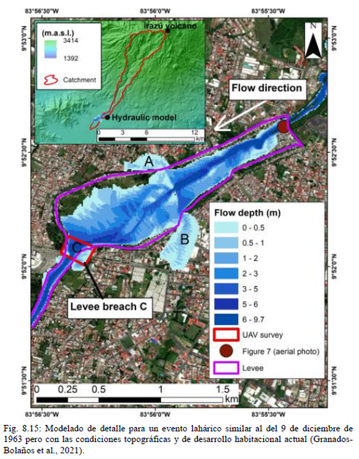
Official, Figure in hazard assessment
Modelado de detalle para un evento lahárico similar al del 9 de diciembre de 1963 pero con las condiciones topográficas y de desarrollo habitacional actual
(Detailed modeling for a laharic event similar to that of December 9, 1963 but with the current topographic and housing development conditions)
Figure 8.15 in: Alvarado, G.E., Campos-Durán, D., Brenes-André, J., Alpízar, Y., Núñez, S., Esquivel, L., Sibaja, J.P. & Fallas, B. (2021). Peligro Volcánico del Irazú, Costa Rica. Comisión Nacional de Prevención de Riesgos y Atención de Emergencias (CNE). Deciembre 2021. (Modified from: Granados-Bolaños et al. 2021).
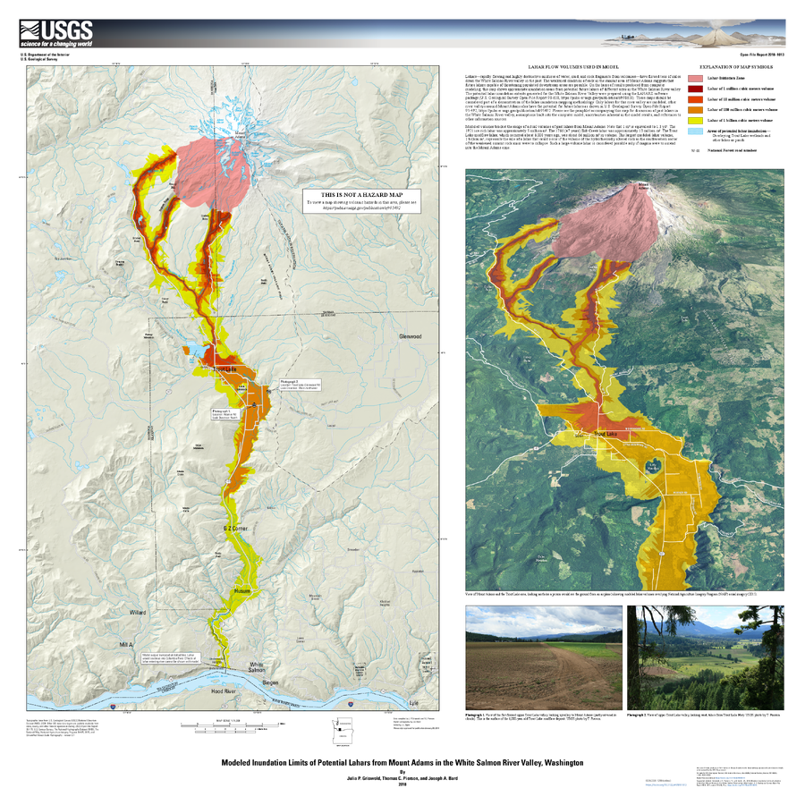
Official, Insert/poster-size map with accompanying report
Modeled Inundation Limits of Potential Lahars from Mount Adams in the White Salmon River Valley, Washington
Griswold, J.P., Pierson, T.C., and Bard J.A. (2018). Modeled inundation limits of potential lahars from Mount Adams in the White Salmon River valley, Washington. U.S. Geological Survey Open-File Report 2018–1013, scale 1:75,000, 14 p. https://doi.org/10.3133/ofr20181013
Soufrière St. Vincent, Saint Vincent and the Grenadines
Official, Figure on website
Overland Community Multi-Hazard Map
The University of the West Indies Seismic Research Centre (UWI-SRC) and National Emergency Management Organization (NEMO). (2021). Overland Community Multi-Hazard Map. https://uwiseismic.com/wp-content/uploads/2021/10/Overland-Hazard-Map-scaled.jpg
Soufrière St. Vincent, Saint Vincent and the Grenadines
Official, Figure on website
Owia/Point Community Multi-Hazard Map
The University of the West Indies Seismic Research Centre (UWI-SRC) and National Emergency Management Organization (NEMO). (2021). Owia/Point Community Multi-Hazard Map. https://uwiseismic.com/wp-content/uploads/2021/10/Owia-Point-Hazard-Map-scaled.jpg
Soufrière St. Vincent, Saint Vincent and the Grenadines
Official, Figure on website
Rose Hall Community Multi-Hazard Map
The University of the West Indies Seismic Research Centre (UWI-SRC) and National Emergency Management Organization (NEMO). (2021). Rose Hall Community Multi-Hazard Map. https://uwiseismic.com/wp-content/uploads/2021/10/Rose-Hall_Hazard-Map-scaled.jpg
Soufrière St. Vincent, Saint Vincent and the Grenadines
Official, Figure on website
Sandy Bay Community Multi-Hazard Map
The University of the West Indies Seismic Research Centre (UWI-SRC) and National Emergency Management Organization (NEMO). (2021). Sandy Bay Community Multi-Hazard Map. https://uwiseismic.com/wp-content/uploads/2021/10/Sandy-Bay_Hazard-Map-scaled.jpg
Soufrière St. Vincent, Saint Vincent and the Grenadines
Official, Figure on website
Spring Village Community Multi-Hazard Map
The University of the West Indies Seismic Research Centre (UWI-SRC) and National Emergency Management Organization (NEMO). (2021). Spring Village Community Multi-Hazard Map. https://uwiseismic.com/wp-content/uploads/2021/10/Spring-Village-Hazard-Map-scaled.jpg