
Advanced Search for Maps
Showing 21-30 of 1237
Official, Flyer, brochure, short fact-sheet, or handout
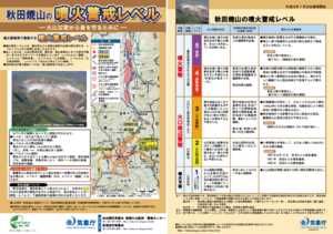
Akita-Yakeyama Volcanic Alert Levels
Japan Meteorological Agency. (2016). Akita-Yakeyama Volcanic Alert Levels. Volcano Monitoring and Warning Center, Volcano Division, Earthquake and Volcano Department.
Official, Map in a booklet, long fact-sheet, or handbook
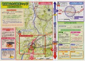
Akita-Yakeyama Volcanic Disaster Prevention Map
Akita Prefecture. (2002). Akita-Yakeyama Volcanic Disaster Prevention Map.
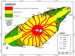
Figure in a journal article
Ambae
Cronin, S.J., Gaylord, D.R., Charley, D., Alloway, B.V., Wallez, S., & Esau, J.W. (2004). Participatory methods of incorporating scientific with traditional knowledge for volcanic hazard management on Ambae Island, Vanuatu. Bulletin of volcanology, 66(7), p. 652-668. https://doi.org/10.1007/s00445-004-0347-9. (Reprinted in: Cronin, S. J., & Németh, K., Stewart, R.B. (2006). Volcanic hazards planning on rifting island and fissure volcanoes. Joint Conference of the Geological Society of New Zealand and the New Zealand Geophysical Society.)
Official, Map sheet or poster
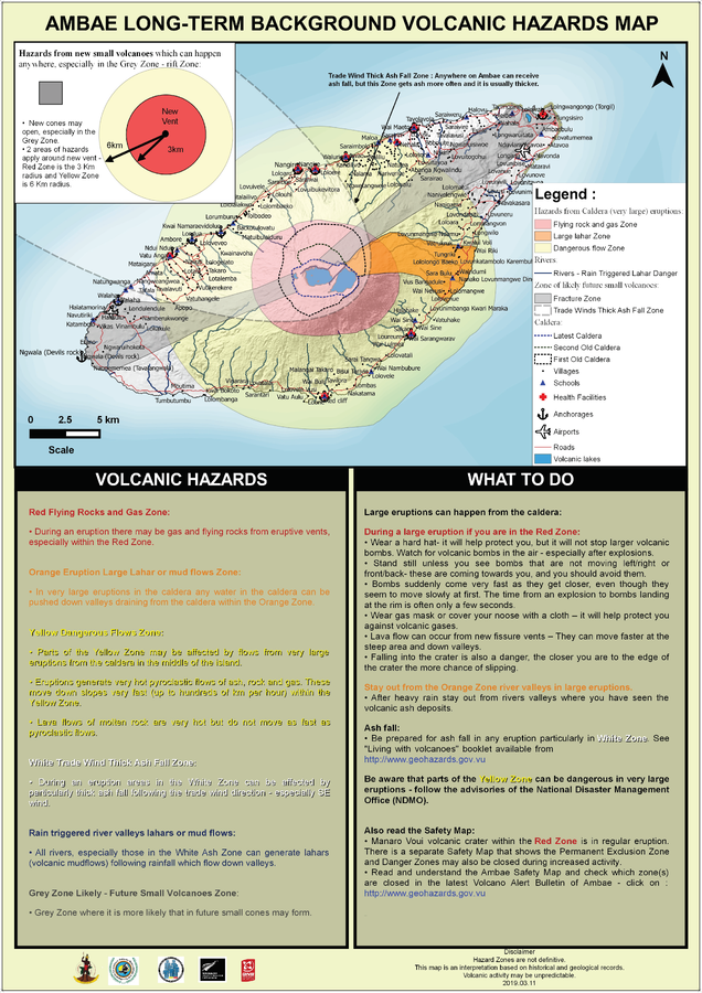
Ambae Long-Term Background Volcanic Hazards Map
Vanuatu Meteorology & Geo-Hazards Department. (2019). Ambae Long-Term Background Volcanic Hazards Map. Government of Vanuatu, Vanuatu Meteorology & Geo-Hazards Department, Vanuatu National Disaster Risk Management Office, New Zealand Foreign Affairs & Trade Aid Programme, GNS Science.
Official, Map sheet or poster
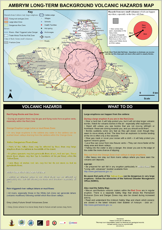
Ambrym Long-Term Background Volcanic Hazards Map
Vanuatu Meteorology & Geo-Hazards Department. (2016). Ambrym Long-Term Background Volcanic Hazards Map. Government of Vanuatu, Vanuatu Meteorology & Geo-Hazards Department, Vanuatu National Disaster Risk Management Office, New Zealand Foreign Affairs & Trade Aid Programme, GNS Science, The Vanuatu Red Cross Society, Croix Rouge Francaise, USAID.
Official, Interactive web-based map
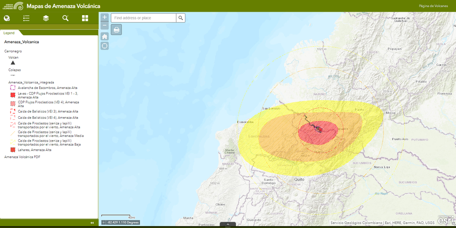
Amenaza Cerro Negro
(Cerro Negro hazards)
Servicio Geológico Colombiano (SGC). Amenaza Cerro-Negro.

Official, Interactive web-based map
Amenaza Chiles
(Chiles Hazards)
Servicio Geológico Colombiano (SGC). Amenaza Chiles.
Official, Interactive web-based map
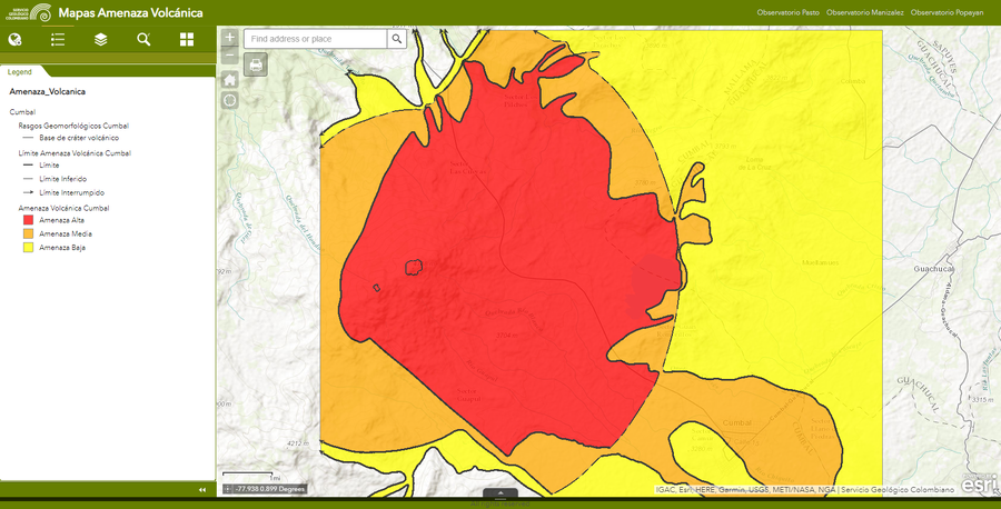
Amenaza Cumbal
(Cumbal Hazards)
Servicio Geológico Colombiano (SGC). Amenaza Cumbal.
Official, Unknown format
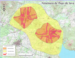
Amenaza de flujo de lava
(Lava flow threat)
Instituto Nicaragüense de Estudios Territoriales (INETER). (2006). Amenaza de flujo de lava.
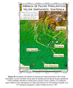
Official, Figure in hazard assessment
Amenaza de Flujos Piroclásticos Volcán Santiaguito, Guatemala
(Threat of Pyroclastic Flows Santiaguito Volcano, Guatemala)
Figure 26 in: UNESCO, Instituto Nacional de Sismología, Vulcanología, Meteorología e Hidrología (INSIVUMEH), Coordinadora Nacional para la Reducción de Desastres (CONRED), Instituto Geográfico Nacional (IGN), Facultad de Agronomía (FAUSAC), Universidad de San Carlos de Guatemala Centro de Estudios Superiores de Energía y Minas (CESEM), Universidad de San Carlos de Guatemala, Escuela Regional de Ingeniería Sanitaria (ERIS). (2003). Zonificación de Amenazas Naturales en la cuenca del río Samalá y Análisis de vulnerabilidad y riesgo en la población de San Sebastián Retalhuleu, Guatemala, Centro América. Capacity Building for Natural Disaster Reduction (CBNDR) Regional Action Program for Central America (RAPCA). Guatemala, Septiembre 2003.