
Advanced Search for Maps
Showing 41-50 of 69

Official, Flyer, brochure, short fact-sheet, or handout
Niigata-Yakeyama Volcanic Alert Levels
Japan Meteorological Agency. (2016). Niigata-Yakeyama Volcanic Alert Levels. Volcano Monitoring and Warning Center, Volcano Division, Earthquake and Volcano Department.
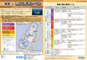
Official, Flyer, brochure, short fact-sheet, or handout
Niijima Volcanic Alert Levels
Japan Meteorological Agency. (2019). Niijima Volcanic Alert Levels. Volcano Monitoring and Warning Center, Volcano Division, Earthquake and Volcano Department.

Official, Flyer, brochure, short fact-sheet, or handout
Nikko-Shiranesan Volcanic Alert Levels
Japan Meteorological Agency. (2016). Nikko-Shiranesan Volcanic Alert Levels. Volcano Monitoring and Warning Center, Volcano Division, Earthquake and Volcano Department.
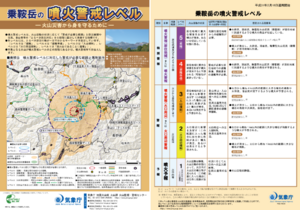
Official, Flyer, brochure, short fact-sheet, or handout
Norikuradake Volcanic Alert Levels
Japan Meteorological Agency. (2020). Norikuradake Volcanic Alert Levels. Volcano Monitoring and Warning Center, Volcano Division, Earthquake and Volcano Department.
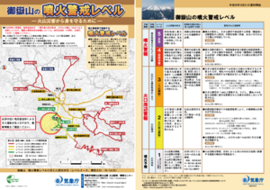
Official, Flyer, brochure, short fact-sheet, or handout
Ontakesan Volcanic Alert Levels
Japan Meteorological Agency. (2018). Ontakesan Volcanic Alert Levels. Volcano Monitoring and Warning Center, Volcano Division, Earthquake and Volcano Department.

Official, Flyer, brochure, short fact-sheet, or handout
Popocatépetl - Avalanchas
(Popocatépetl - Avalanches)
Map 5 in: Instituto de Geofísica Universidad Nacional Autónoma de México (IG-UNAM), Centro Nacional de Prevención de Desastres (CENAPRED), Secretaría de Gobernación (SEGOB) (2016). Popocatépetl. Gobierno de México. (Simplified from: Martin Del Pozzo et al. 2016)
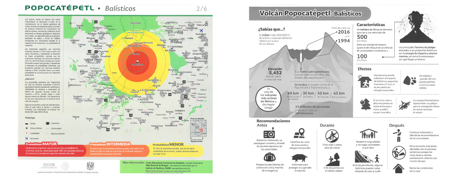
Official, Flyer, brochure, short fact-sheet, or handout
Popocatépetl - Balísticos
(Popocatépetl - Ballistics)
Map 2 in: Instituto de Geofísica Universidad Nacional Autónoma de México (IG-UNAM), Centro Nacional de Prevención de Desastres (CENAPRED), Secretaría de Gobernación (SEGOB). (2016). Popocatépetl - Balísticos. Gobierno de México. (Simplified from: Martin Del Pozzo et al. 2016)
Official, Flyer, brochure, short fact-sheet, or handout
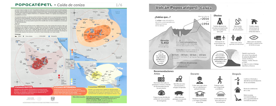
Popocatépetl - Caída de ceniza
(Popocatépetl - Ash fall)
Map 1 in: Instituto de Geofísica Universidad Nacional Autónoma de México (IG-UNAM), Centro Nacional de Prevención de Desastres (CENAPRED), Secretaría de Gobernación (SEGOB). (2016). Popocatépetl - Caída de ceniza. Gobierno de México. (Simplified from: Martin Del Pozzo et al. 2016)
Official, Flyer, brochure, short fact-sheet, or handout
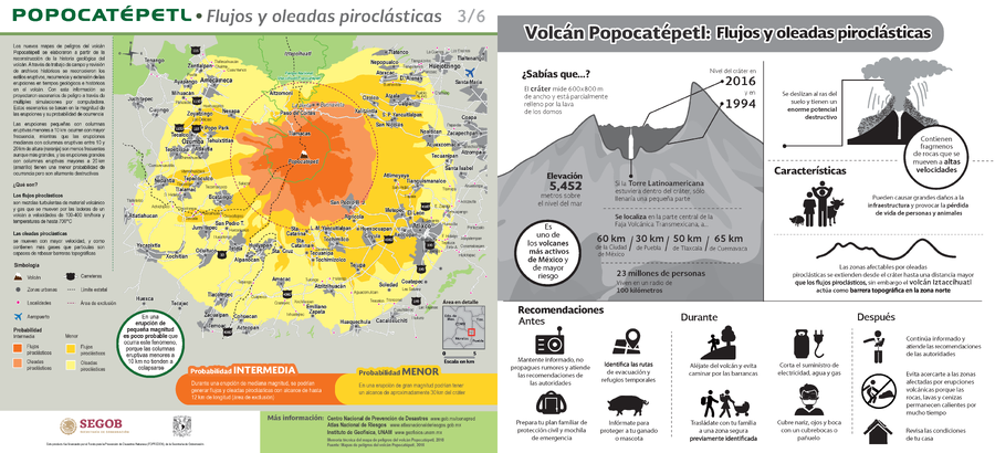
Popocatépetl - Flujos y oleadas piroclásticas
(Popocatépetl - Pyroclastic flows and surges)
Map 3 in: Instituto de Geofísica Universidad Nacional Autónoma de México (IG-UNAM), Centro Nacional de Prevención de Desastres (CENAPRED), Secretaría de Gobernación (SEGOB). (2016). Popocatépetl - Flujos y oleadas piroclásticas. Gobierno de México. (Simplified from: Martin Del Pozzo et al. 2016)
Official, Flyer, brochure, short fact-sheet, or handout
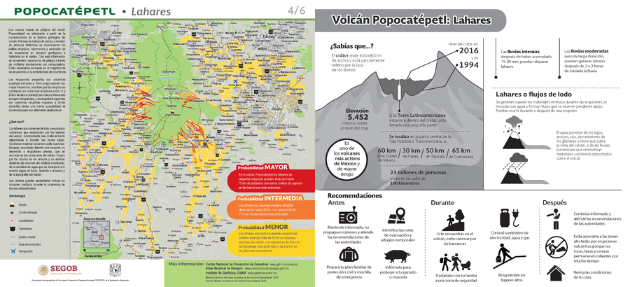
Popocatépetl - Lahares
(Popocatépetl - Lahars)
Map 4 in: Instituto de Geofísica Universidad Nacional Autónoma de México (IG-UNAM), Centro Nacional de Prevención de Desastres (CENAPRED), Secretaría de Gobernación (SEGOB). (2016). Popocatépetl - Lahares. Gobierno de México. (Simplified from: Martin Del Pozzo et al. 2016)