
Advanced Search for Maps
Showing 21-30 of 41
Official, Interactive web-based map
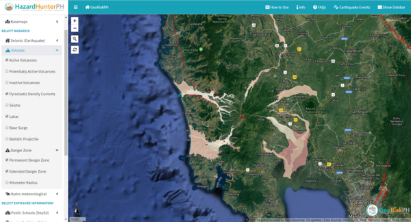
HazardHunterPH Pinatubo
GeoRisk Philippines. HazardHunterPH.
Official, Interactive web-based map
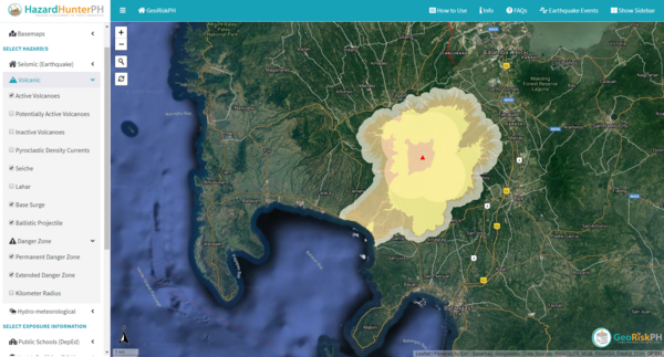
HazardHunterPH Taal
GeoRisk Philippines. HazardHunterPH.
Official, Interactive web-based map
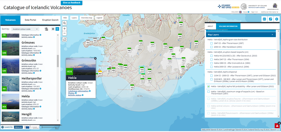
Hekla - Vatnafjöll, tephra fall probability - After Larsen and Gíslason (2013)
Larsen, G. & Thordarson, T. (2019). Hekla. In: Oladottir, B., Larsen, G. & Guðmundsson, M. T. Catalogue of Icelandic Volcanoes. Iceland Meteorological Office (IMO), Univeristy of Iceland, and Civil Protection Department of the National Commissioner of the Iceland Police (CPD-NCIP). (Simplified from: Larsen & Gíslason 2013)
Official, Interactive web-based map
Higashikawa Town Disaster Hazard Map (web version)
Higashikawa Town. (2020). Higashikawa Town Disaster Hazard Map (web version).
Official, Interactive web-based map
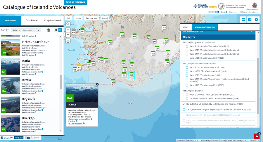
Katla, tephra fall probability - After Larsen and Gíslason (2013)
Larsen, G. & Guðmundsson, M.T. (2019). Katla. In: Oladottir, B., Larsen, G. & Guðmundsson, M. T. Catalogue of Icelandic Volcanoes. Iceland Meteorological Office (IMO), Univeristy of Iceland, and Civil Protection Department of the National Commissioner of the Iceland Police (CPD-NCIP). (Simplified from: Larsen and Gíslason 2013)
Official, Interactive web-based map
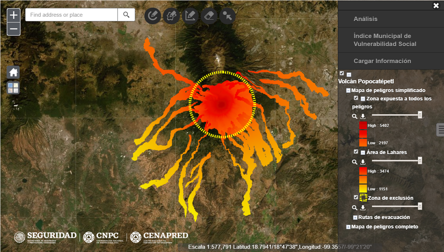
Mapa de Peligros del Volcán Popocatépetl
(Popocatepetl Volcano Hazard Map)
Secretaría de Seguridad y Protección Ciudadana, Coordinación Nacional de Protección Civil (CNPC), & Centro Nacional de Prevención de Desastres (CENEPRED). Mapa de Peligros del Volcán Popocatépetl. Gobierno de México.
Official, Interactive web-based map
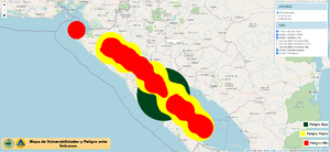
Mapa de Vulnerabilidades y Peligro ante Volcanes
(Map of Vulnerabilities and Danger from Volcanoes)
Instituto Nicaraguense de Estudios Territoriales (INETER). Mapa de Vulnerabilidades y Peligro ante Volcanes. https://gestionderiesgo.ineter.gob.ni/IDE-VulnerabilidadVolcanica/index.html
Official, Interactive web-based map
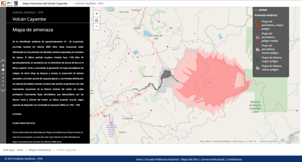
Mapa Interactivo del Volcán Cayambe
(Cayambe Volcano Interactive Map)
Instituto Geofísico de la Escuela Politecnica Nacional (IG-EPN). (2019). Mapa Interactivo del Volcán Cayambe.
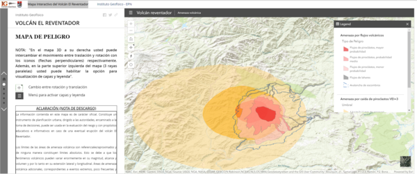
Official, Interactive web-based map
Mapa Interactivo del Volcán el Reventador
(Reventador Volcano Interactive Map)
Instituto Geofísico de la Escuela Politecnica Nacional (IG-EPN). (2019). Mapa Interactivo del Volcán El Reventador.
Official, Interactive web-based map
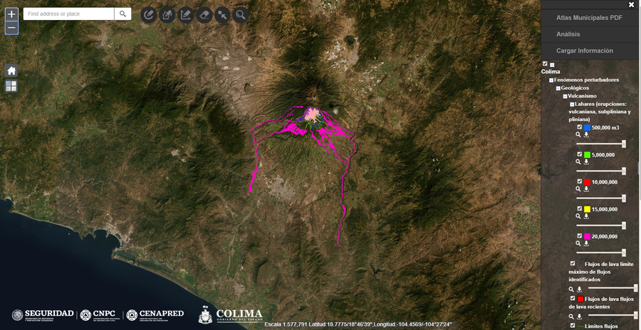
Mapas de Riesgo y Amenaza Volcánica - Atlas de Riesgo de Colima
(Risk Maps and Volcanic Threat - Colima Risk Atlas)
Universidad de Colima. (2017). Mapas de Riesgo y Amenaza Volcánica, Atlas de Riesgo de Colima. In: Centro Nacional de Prevención de Desastres (CENAPRED). Atlas Nacional de Riesgos.