
Advanced Search for Maps
Showing 41-50 of 184
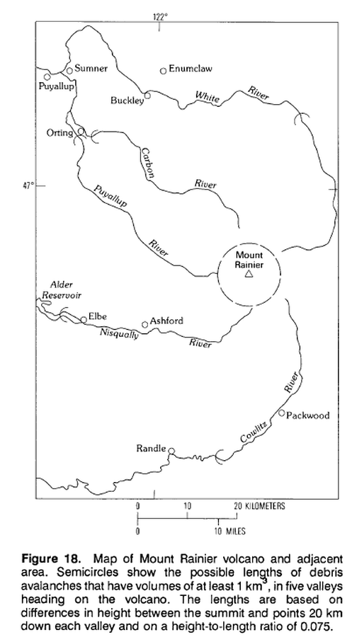
Official, Figure in hazard assessment
Map of Mount Rainier volcano and adjacent area.
Figure 18 in: Crandell, D.R. (1989). Gigantic debris avalanche of Pleistocene age from ancestral Mount Shasta Volcano, California, and debris-avalanche hazard zonation. U.S. Geological Survey, Bulletin 1861, 32 p. https://doi.org/10.3133/b1861
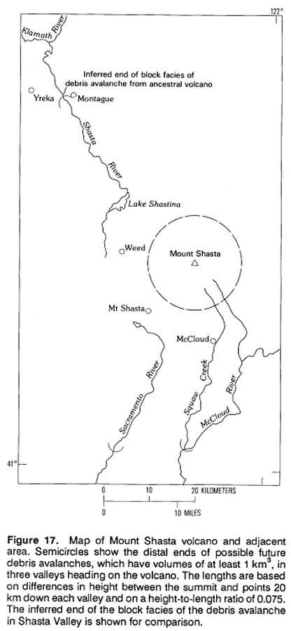
Official, Figure in hazard assessment
Map of Mount Shasta volcano and adjacent area.
Figure 17 in: Crandell, D.R. (1989). Gigantic debris avalanche of Pleistocene age from ancestral Mount Shasta Volcano, California, and debris-avalanche hazard zonation. U.S. Geological Survey, Bulletin 1861, 32 p. https://doi.org/10.3133/b1861
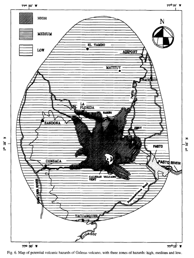
Official, Figure in a journal article
Map of potencial volcanic hazards of Galeras volcano, with three zones of hazards: high, medium and low
Figure 6 in: Artunduaga, A.D.H., & Jiménez, G.P.C. (1997). Third version of the hazard map of Galeras Volcano, Colombia. Journal of Volcanology and Geothermal research, 77(1-4), p. 89-100. https://doi.org/10.1016/S0377-0273(96)00088-1
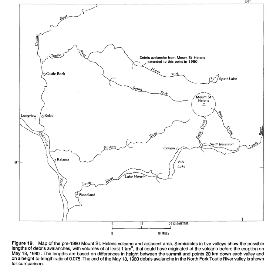
Official, Figure in hazard assessment
Map of pre-1980 Mount St. Helens volcano and adjacent area.
Figure 19 in: Crandell, D.R. (1989). Gigantic debris avalanche of Pleistocene age from ancestral Mount Shasta Volcano, California, and debris-avalanche hazard zonation. U.S. Geological Survey, Bulletin 1861, 32 p. https://doi.org/10.3133/b1861
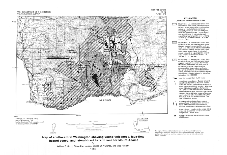
Official, Insert/poster-size map with accompanying report
Map of south-central Washington showing young volcanoes, lava-flow hazard zones, and lateral-blast hazard zone for Mount Adams
Plate 1 in: Scott, W.E., Iverson, R.M., Vallance, J.W., & Hildreth, W. (1995). Volcano Hazards in the Mount Adams Region, Washington. U.S. Geological Survey, Open-File Report 95-492. https://doi.org/10.3133/ofr95492
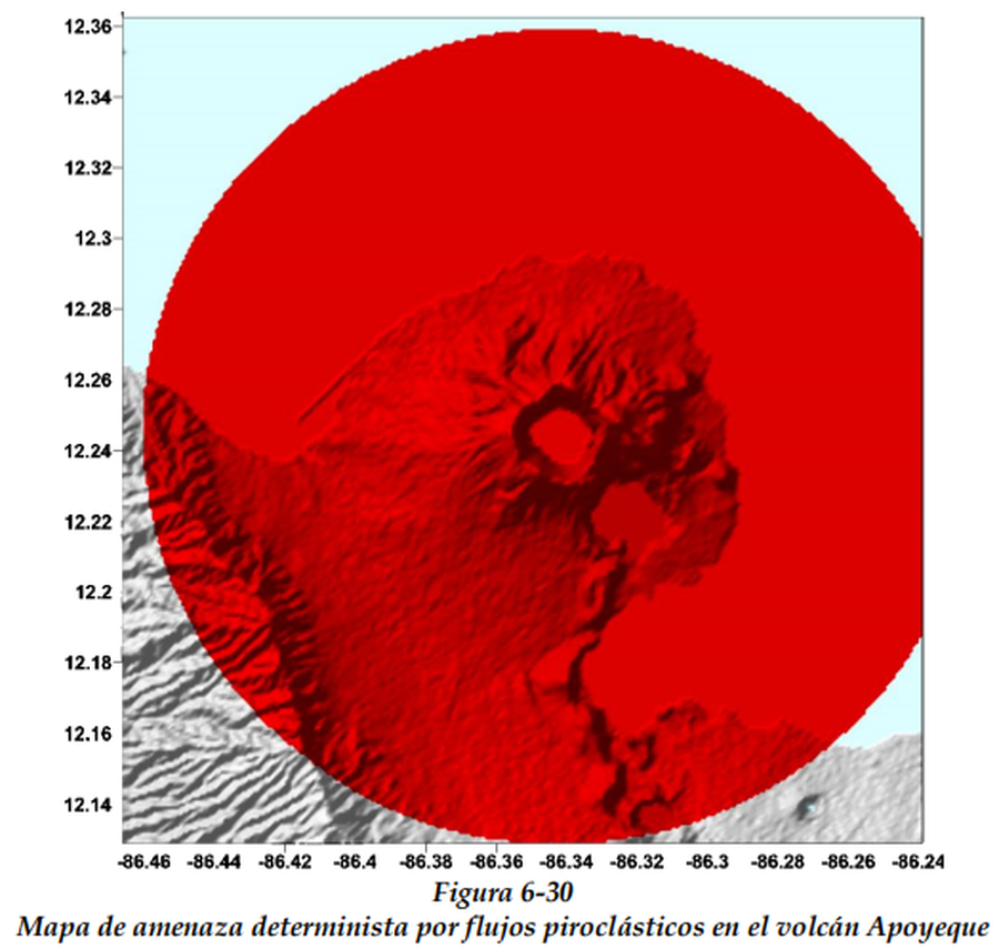
Figure in hazard assessment
Mapa de amenaza determinista por flujos piroclásticos en el volcán Apoyeque
(Deterministic threat map for pyroclastic flows at Apoyeque volcano)
Figure 6-30 in: CAPRA Probabilistic Risk Assessment Initiative. Nicaragua - Tomo I Metodología De Modelación Probabilista De Riesgos Naturales. Informe Técnico ERN-CAPRA-t2-3 Modelación Probabilista De Amenazas Naturales.
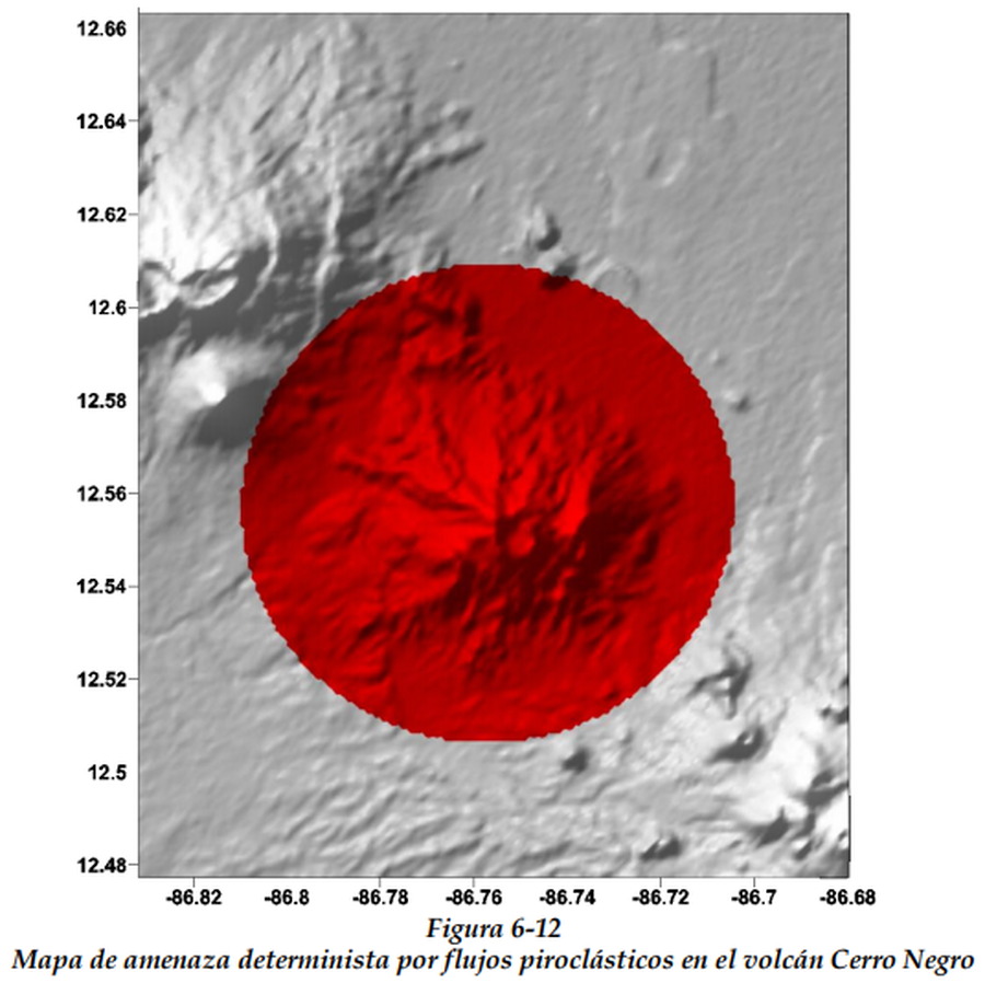
Figure in hazard assessment
Mapa de amenaza determinista por flujos piroclásticos en el volcán Cerro Negro
(Deterministic threat map for pyroclastic flows at Cerro Negro volcano)
Figure 6-12 in: CAPRA Probabilistic Risk Assessment Initiative. Nicaragua - Tomo I Metodología De Modelación Probabilista De Riesgos Naturales. Informe Técnico ERN-CAPRA-t2-3 Modelación Probabilista De Amenazas Naturales.
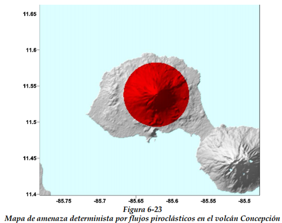
Figure in hazard assessment
Mapa de amenaza determinista por flujos piroclásticos en el volcán Concepción
(Deterministic threat map for pyroclastic flows at Concepción volcano)
Figure 6-23 in: CAPRA Probabilistic Risk Assessment Initiative. Nicaragua - Tomo I Metodología De Modelación Probabilista De Riesgos Naturales. Informe Técnico ERN-CAPRA-t2-3 Modelación Probabilista De Amenazas Naturales.
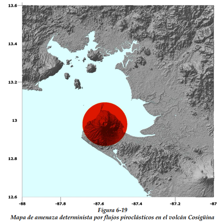
Figure in hazard assessment
Mapa de amenaza determinista por flujos piroclásticos en el volcán Cosigüina
(Deterministic threat map for lava flows at Cosigüina volcano)
Figure 6-19 in: CAPRA Probabilistic Risk Assessment Initiative. Nicaragua - Tomo I Metodología De Modelación Probabilista De Riesgos Naturales. Informe Técnico ERN-CAPRA-t2-3 Modelación Probabilista De Amenazas Naturales.
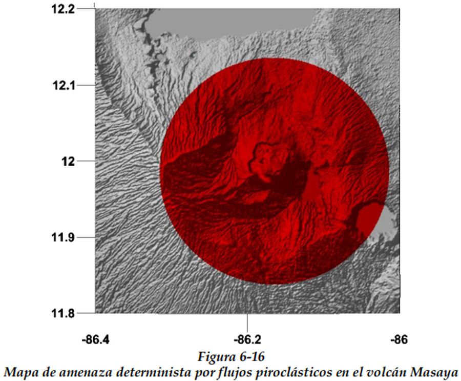
Figure in hazard assessment
Mapa de amenaza determinista por flujos piroclásticos en el volcán Masaya
(Deterministic threat map for pyroclastic flows at Masaya volcano)
Figure 6-16 in: CAPRA Probabilistic Risk Assessment Initiative. Nicaragua - Tomo I Metodología De Modelación Probabilista De Riesgos Naturales. Informe Técnico ERN-CAPRA-t2-3 Modelación Probabilista De Amenazas Naturales.