
Advanced Search for Maps
Showing 21-30 of 42
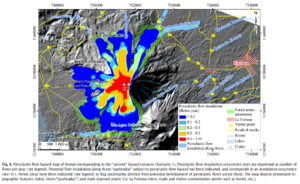
Figure in a journal article
Pyroclastic flow hazard map of Arenal corresponding to the “current” hazard scenario (Scenario 1)
Figure 8 in: Oramas-Dorta, D., Cole, P. D., Wadge, G., Alvarado, G. E., & Soto, G. J. (2012). Pyroclastic flow hazard at Arenal volcano, Costa Rica: Scenarios and assessment. Journal of volcanology and geothermal research, 247, 74-92. https://doi.org/10.1016/j.jvolgeores.2012.07.015

Figure in a journal article
Pyroclastic flow hazard map of Arenal corresponding to the “near-future” hazard scenario (Scenario 2)
Figure 9 in: Oramas-Dorta, D., Cole, P. D., Wadge, G., Alvarado, G. E., & Soto, G. J. (2012). Pyroclastic flow hazard at Arenal volcano, Costa Rica: Scenarios and assessment. Journal of volcanology and geothermal research, 247, 74-92. https://doi.org/10.1016/j.jvolgeores.2012.07.015
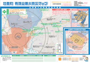
Official, Map sheet or poster
Sobetsu Usuzan Eruption Disaster Prevention Map
Sobetsu Town Office General Affairs Division. (2013). Sobetsu Usuzan Eruption Disaster Prevention Map

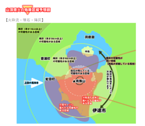
Official, Map in a booklet, long fact-sheet, or handbook
Steam eruption risk area prediction map (ash fall, volcanic blocks only)
Page 6 in: Nasudake Volcano Disaster Prevention Council. (2014). Nasudake Volcano Disaster Prevention Handbook.

Official, Map in a booklet, long fact-sheet, or handbook
Steam eruption risk area prediction map (ash fall, volcanic blocks only)
Page 6 in: Nasudake Volcano Disaster Prevention Council. (2010). Volcanic disaster prevention handbook of Mt. Nasudake.
Official, Figure on website
Usu Volcano Disaster Prevention Map [Summit eruption: Pyroclastic flow, volcanic block, ash fall]
Toyoura Town. (Year Unknown). Usu Volcano Disaster Prevention Map. https://www.town.toyoura.hokkaido.jp/hotnews/detail/00000340.html
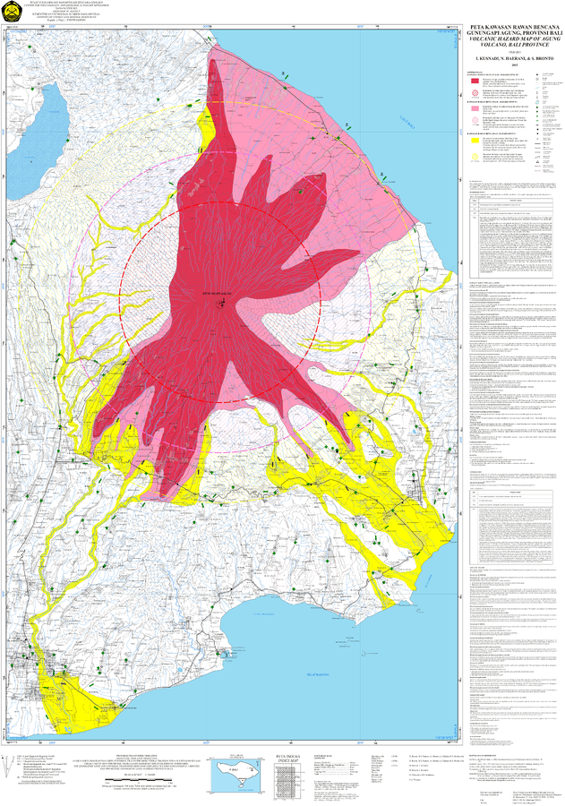
Official, Map sheet or poster
Volcanic Hazard Map of Agung Volcano, Bali Province
Kusnadi, I., Haerani, N., & Bronto, S. (2015). Volcanic Hazard Map of Agung Volcano, Bali Province. Center for Volcanology and Geological Hazard Mitigation (CVGHM). Bandung.
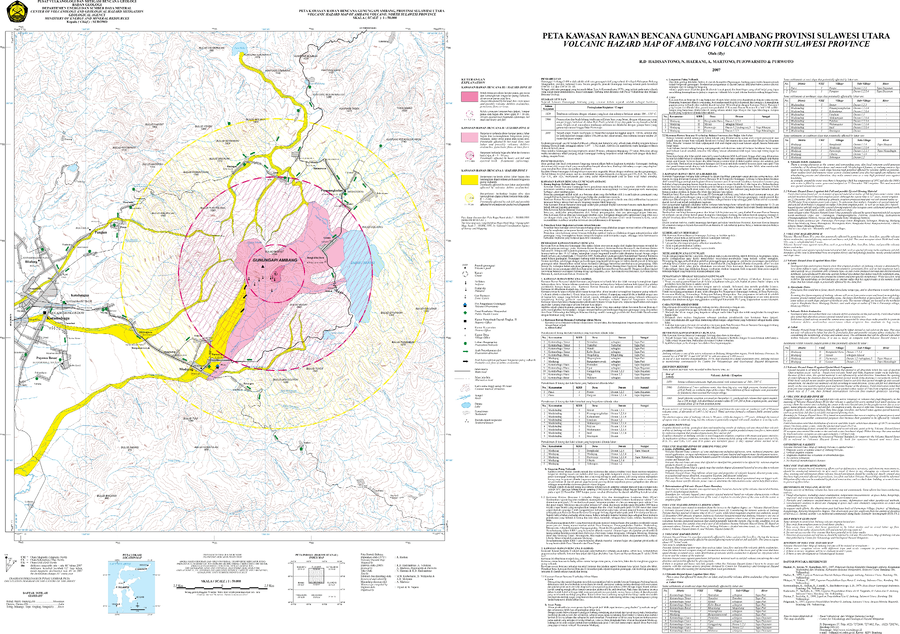
Official, Map sheet or poster
Volcanic Hazard Map of Ambang Volcano North Sulawesi Province
Hadisantono, R.D., Haerani, N., Martono, A., Pujowarsito, & Purwoto. (2007). Volcanic Hazard Map of Ambang Volcano North Sulawesi Province. Center for Volcanology and Geological Hazard Mitigation (CVGHM).
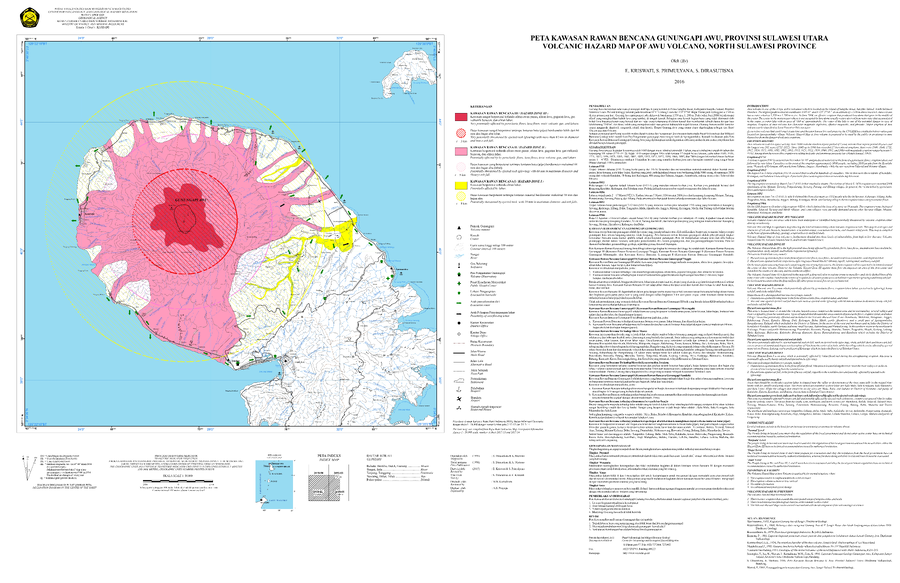
Official, Map sheet or poster
Volcanic Hazard Map of Awu Volcano, North Sulawesi Province
Kriswati, E., Primulyana, S., & Dirasutisna S. (2016). Volcanic Hazard Map of Awu Volcano, North Sulawesi Province. Center for Volcanology and Geological Hazard Mitigation (CVGHM).
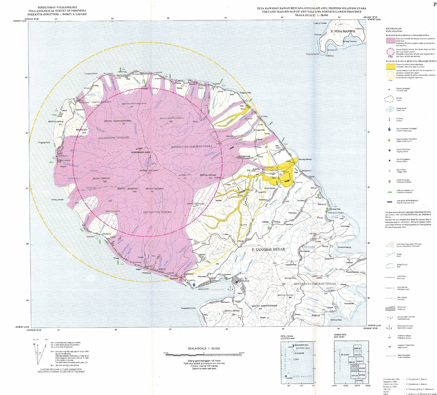
Official, Map sheet or poster
Volcanic Hazard Map of Awu Volcano, North Sulawesi Province
Dirasutisna, S., Martono, A., Hadisantono, R.D., Pardyanto, L., Effendi, A.C., & Modjo, W.S. (1996). Volcanic Hazard Map of Awu Volcano, North Sulawesi Province. Volcanological Survey of Indonesia (VSI).