
Advanced Search for Maps
Showing 61-70 of 382
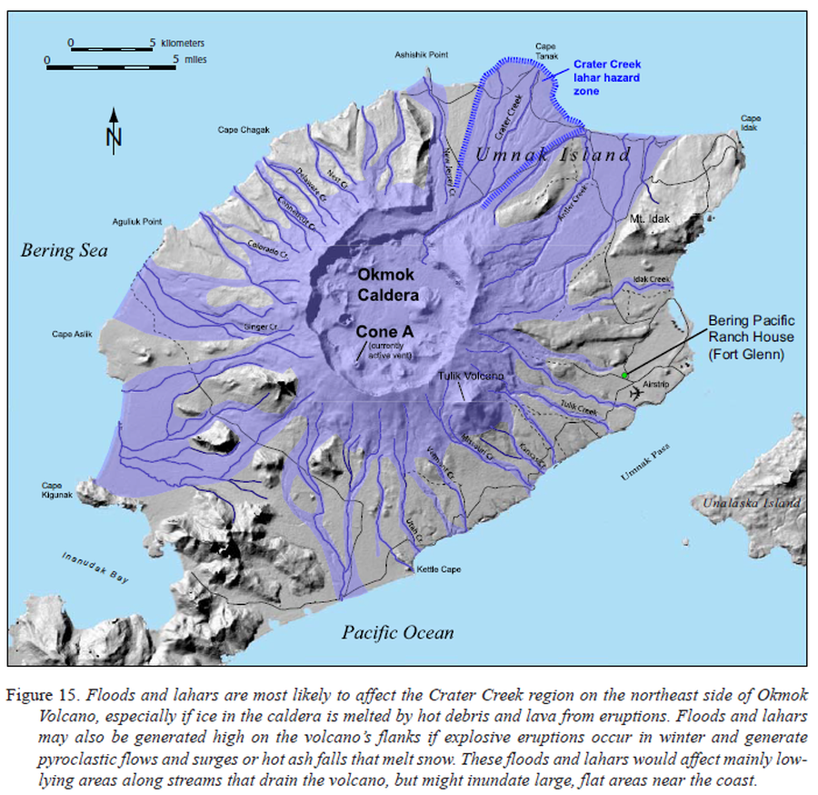
Official, Figure in hazard assessment
Floods and lahars are most likely to affect the Crater Creek region on the northeast side of Okmok Volcano
Figure 15 in: Beget, J.E., Larsen, J.F., Neal, C.A., Nye, C.J., & Schaefer, J.R. (2005). Preliminary volcano-hazard assessment for Okmok Volcano, Umnak Island, Alaska. Department of Natural Resources, Division of Geological & Geophysical Surveys (DGGS), Report of Investigation RI 2004-3, 32 p., 1 sheet, scale 1:150,000. http://doi.org/10.14509/7042

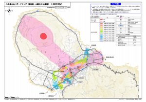
Official, Map sheet or poster
Fuji City Volcano Disaster Prevention Map
Figure 6.3.13 in: Mt. Fuji Hazard Map Review Committee. (2004). Mt. Fuji Hazard Map Review Committee Report. June 2004. https://www.bousai.go.jp/kazan/fuji_map/pdf/report_200406.pdf
Official, Map sheet or poster
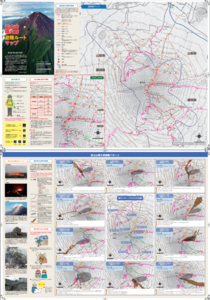
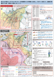
Fujisan Eruption Evacuation Route Map
Fujisan Eruption Evacuation Route Map
Official, Flyer, brochure, short fact-sheet, or handout
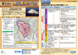
Fujisan Volcanic Alert Levels
Japan Meteorological Agency. (2016). Fujisan Volcanic Alert Levels. Volcano Monitoring and Warning Center, Volcano Division, Earthquake and Volcano Department.
Official, Map sheet or poster
Fujiyoshida City Volcano Disaster Prevention Map
Figure 6.3.11 in: Mt. Fuji Hazard Map Review Committee. (2004). Mt. Fuji Hazard Map Review Committee Report. June 2004. https://www.bousai.go.jp/kazan/fuji_map/pdf/report_200406.pdf
Official, Insert/poster-size map with accompanying report
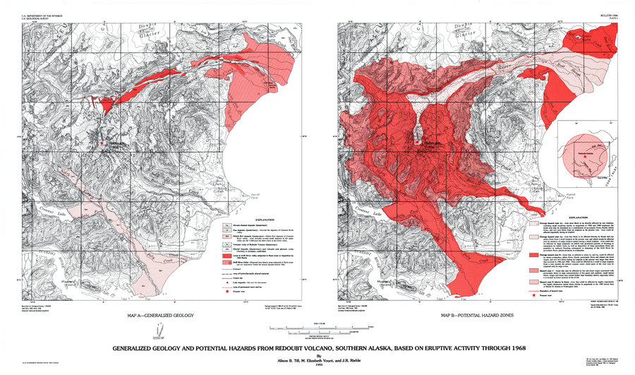
Generalized Geology and Potential Hazards from Redoubt Volcano, Southern Alaska, Based on Eruptive Activity Through 1968
Plate 1 in: Till, A.B., Yount, M.E., & Riehle, J.R. (1993). Redoubt Volcano, southern Alaska; a hazard assessment based on eruptive activity through 1968. U.S. Geological Survey, Bulletin 1996, 19 p., 1 plate. https://doi.org/10.3133/b1996
Official, Map sheet or poster
Gotemba Volcano Disaster Prevention Map
Figure 6.3.12 in: Mt. Fuji Hazard Map Review Committee. (2004). Mt. Fuji Hazard Map Review Committee Report. June 2004. https://www.bousai.go.jp/kazan/fuji_map/pdf/report_200406.pdf
Official, Insert/poster-size map with accompanying report
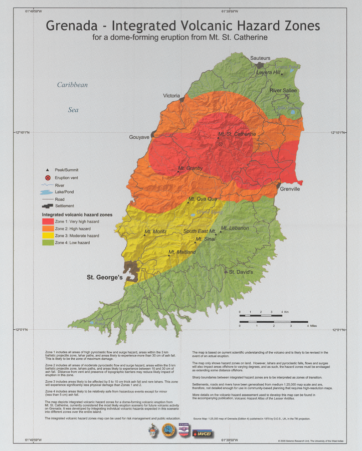
Grenada - Integrated volcanic hazard map for a dome-forming eruption from Mt. St. Catherine
Pocket Insert in: Robertson, R. (2005). Grenada. In: Lindsay, J.M., Shepherd, J.B., Robertson, R.E.A., & Ali, S. (Eds) Volcanic hazard atlas of the Lesser Antilles. Seismic Research Unit, The University of the West Indies, Trinidad and Tobago, W.I., p. 49-66
Official, Map sheet or poster
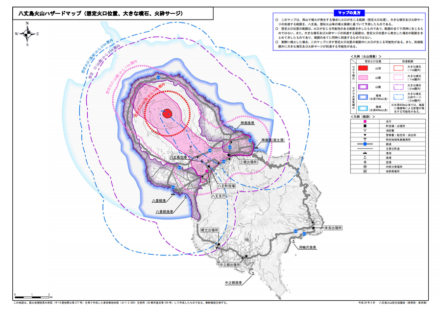
Hachijojima volcano hazard map (assumed crater position, volcanic blocks, pyroclastic surge)
Hachijojima Volcano Disaster Prevention Council. (2017). Hachijojima volcano hazard map. Disaster Prevention Division, Bureau of General Affairs, Tokyo Metropolitan Government.
Official, Map sheet or poster
Hachijojima Volcano Hazard Map (Lava flow: Flank craters (base of volcano), 16 million m³ DRE)
Hachijojima Volcano Disaster Prevention Council. (2017). Hachijojima volcano hazard map. Disaster Prevention Division, Bureau of General Affairs, Tokyo Metropolitan Government.