
Advanced Search for Maps
Showing 31-40 of 382

Official, Figure in hazard assessment
Areas likely to be affected by lahars, lahar-runout flows, and floods during eruptions of Redoubt Volcano.
Figure 9 in: Waythomas, C.F., Dorava, J.M., Miller, T.P., Neal, C.A. & McGimsey, R.G. (1997). Preliminary volcano-hazard assessment for Redoubt Volcano, Alaska. U.S. Geological Survey, Open-File Report 97-857, 40 p., 1 plate. https://doi.org/10.3133/ofr97857
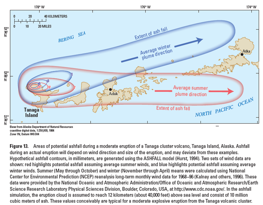
Official, Figure in hazard assessment
Areas of potential ashfall during a moderate eruption of a Tanaga cluster volcano, Tanaga Island, Alaska
Figure 13 in: Coombs, M.L., McGimsey, R.G. & Browne, B.L. (2007). Preliminary volcano-hazard assessment for the Tanaga volcanic cluster, Tanaga Island, Alaska. U.S. Geological Survey, Scientific Investigations Report 2007-5094, 41 p., 1 plate. https://doi.org/10.3133/sir20075094
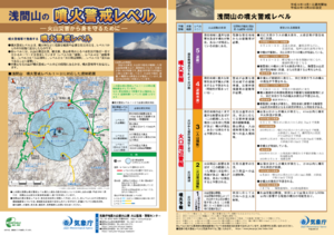
Official, Flyer, brochure, short fact-sheet, or handout
Asamayama Volcanic Alert Levels
Japan Meteorological Agency. (2016). Asamayama Volcanic Alert Levels. Volcano Monitoring and Warning Center, Volcano Division, Earthquake and Volcano Department.
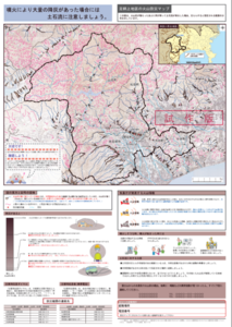
Official, Map sheet or poster
Ashigarakami District Volcanic Disaster Prevention Map
Figure 6.3.14 in: Mt. Fuji Hazard Map Review Committee. (2004). Mt. Fuji Hazard Map Review Committee Report. June 2004. https://www.bousai.go.jp/kazan/fuji_map/pdf/report_200406.pdf
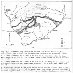
Figure in a journal article
Assessment and zonation of hazards from future lahars of phreatic and collapse-type at Soufrière in Guadeloupe (according to Westercamp, 1981b)
Figure 10.5 in: Westercamp, D. (1983). Appraisal and zonation of volcanic hazards in the French Lesser Antilles: preliminary results. In: Tazieff, H. & Sabroux, J.-C. (Eds.) Forecasting Volcanic Events, Elsevier, Amsterdam, p. 111-130.
Official, Map in a booklet, long fact-sheet, or handbook
Assumed future eruption location and magnitude of eruption
Page 7 in: Towada Volcanic Hazards Mitigation Committee. (2018). Towada Volcano Hazard Expected Impact Area Map. Omori Prefecture Disaster Risk Management Division, Akita Prefecture Disaster Prevention Division, Nagano City General Affairs Division, Kosaka Town General Affairs Division.
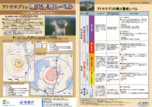
Official, Flyer, brochure, short fact-sheet, or handout
Atosanupuri Volcanic Alert Levels
Japan Meteorological Agency. (2018). Atosanupuri Volcanic Alert Levels. Volcano Monitoring and Warning Center, Volcano Division, Earthquake and Volcano Department.
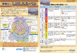
Official, Flyer, brochure, short fact-sheet, or handout
Bandaisan Volcanic Alert Levels
Japan Meteorological Agency. (2019). Bandaisan Volcanic Alert Levels. Volcano Monitoring and Warning Center, Volcano Division, Earthquake and Volcano Department.
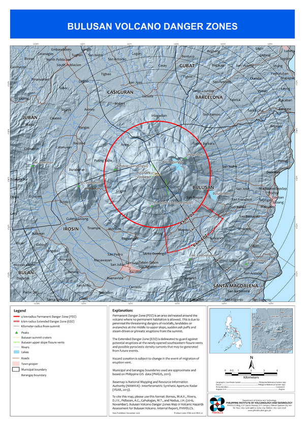
Official, Insert/poster-size map with accompanying report
Bulusan Volcano Danger Zones
Bornas, M.A.V., Rivera, D.J.V., Pidlaoan, A.C., Cahulogan, M.T., & Nadua, J.H. (2016). Bulusan Volcano Danger Zones Map. in: Volcanic Hazard Assessment for Bulusan Volcano. Internal Report, Philippine Institute of Volcanology and Seismology (PHIVOLCS)..

Official, Insert/poster-size map with accompanying report
Bulusan Volcano Lahar Hazard Map
Rivera, D.J.V., Bornas, M.A.V., Pidlaoan, A.C., Cahulogan, M.T., & Nadua, J.H. (2016). Bulusan Volcano Lahar Hazard Map. in: Volcanic Hazard Assessment for Bulusan Volcano. Internal Report, Philippine Institute of Volcanology and Seismology (PHIVOLCS).