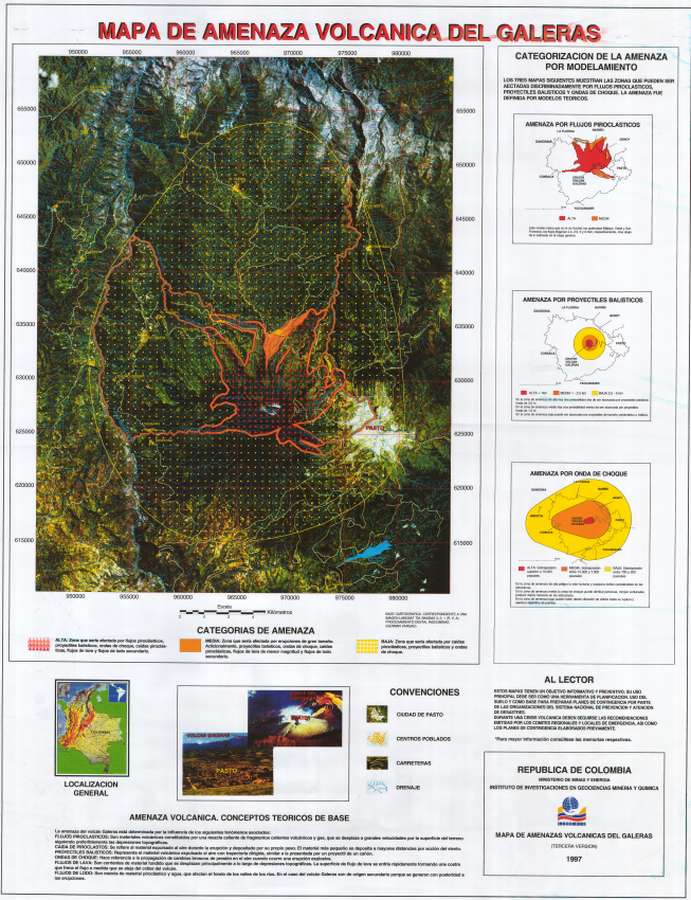
Mapa de Amenaza Volcánica del Galeras, Tercera Version
Galeras Volcanic Hazard Map, Third Version
Galeras, Colombia, 1997
Pocket insert in: Instituto Colombiano de Geología y Minería (INGEOMINAS). (1997). Mapa de Amenaza Volcánica del Galeras. Tercera versión. Publicación Especial de INGEOMINAS.
This map was produced by an official agency, but is NOT the most recent, most complete, or main operational map.
For the current operational hazard map, please consult the proper institutional authorities.

Click on image for full-size map. If link seems broken, try the archived version.
Artunduaga, A.D.H., & Jiménez, G.P.C. (1997). Third version of the hazard map of Galeras Volcano, Colombia. Journal of Volcanology and Geothermal research, 77(1-4), p. 89-100. https://doi.org/10.1016/S0377-0273(96)00088-1Map Set
https://doi.org/10.1016/S0377-0273(96)00088-1
Other Maps In Set:
Map Data
Map ID 1252 Hazard Process(es) Ballistics; Lahars; Lava flows; PDCs; Shockwaves; Tephra fall Hazard Zone Presentation Hazard level- and process-focused: Hazards are both combined by hazard level and separated by hazard process type on a main map and series of insets Temporal Scale Background, or long-term, map Spatial Scale Volcano and surrounding area Publication Format Poster-style map insert in hazard assessment Zonation Method(s) Geologic history; Scenario modeling Zonation Model(s) Energy cone or line (Heim 1932; Sheridan 1979; Sheridan & Malin 1983); FLOW2D or FLOW3D (Sheridan & Macías 1992; Kover 1995); Prandl-Meyer shockwave model (White 1985) Scenario(s) Considered Specific past eruption Hazard Zone Label(s) Qualitative relative probability (e.g. high-medium-low) Probability Definition(s) Qualitative relative probability (e.g. high-medium-low) Purpose Land-use planning: Intended to inform citing of facilities, building restrictions, resource management, and infrastructure development Audience Multiple audiences (usually the public, civil authorities, and land-use planners) Language(s) Spanish Basemap(s) Satellite image Basemap overlay(s) Street map Diemsionality Planimetric (2D or map) view Color Scheme Red to Yellow