
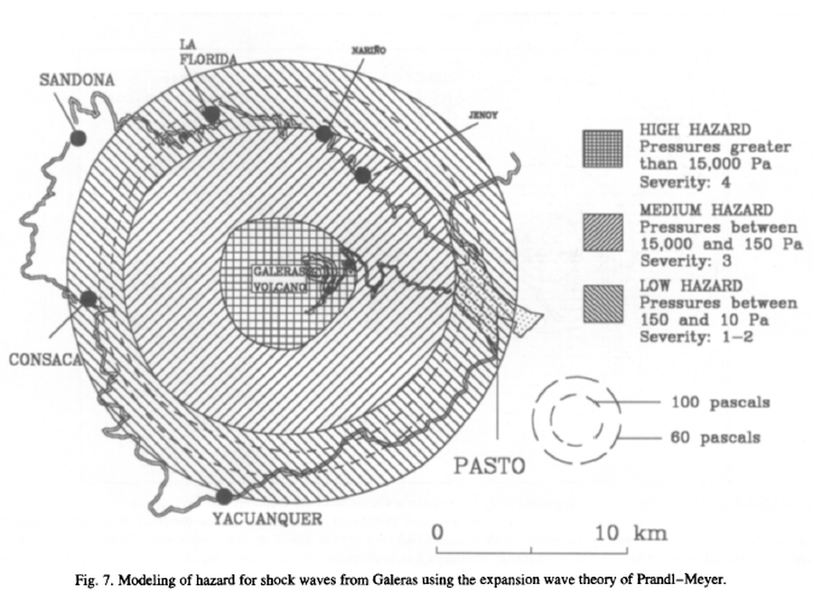
Modeling of hazard for shock waves from Galeras using the expansion wave theory of Prandl-Meyer
Galeras, Colombia, 1997
Figure 7 in: Artunduaga, A.D.H., & Jiménez, G.P.C. (1997). Third version of the hazard map of Galeras Volcano, Colombia. Journal of Volcanology and Geothermal research, 77(1-4), p. 89-100. https://doi.org/10.1016/S0377-0273(96)00088-1
This map was produced by an official agency, but is NOT the most recent, most complete, or main operational map.
For the current operational hazard map, please consult the proper institutional authorities.
Click on image for full-size map.
Map Set
Artunduaga, A.D.H., & Jiménez, G.P.C. (1997). Third version of the hazard map of Galeras Volcano, Colombia. Journal of Volcanology and Geothermal research, 77(1-4), p. 89-100. https://doi.org/10.1016/S0377-0273(96)00088-1
https://doi.org/10.1016/S0377-0273(96)00088-1
Other Maps In Set:
- Mapa de Amenaza Volcánica del Galeras, Tercera Version
- High Hazard Area of Pyroclastic Flows. High Hazard Area of Lahars. Area Affedted by Pyroclastic Falls. High Hazard Area of Lavas Flows.
- Map of potencial volcanic hazards of Galeras volcano, with three zones of hazards: high, medium and low
- Modeling of hazard for ballistic fragments using information collected from the eruptions that have occurred during the last seven years of surveillance of Galeras
- Map of probabilistic zoning, showing weighted severity values
Map Data
Map ID 1255 Hazard Process(es) Shockwaves Hazard Zone Presentation Single hazard: A single hazard process is represented on a main map panel Temporal Scale Background, or long-term, map Spatial Scale Volcano and surrounding area Publication Format Figure in a journal article Zonation Method(s) Scenario modeling Zonation Model(s) Prandl-Meyer shockwave model (White 1985) Scenario(s) Considered Specific past eruption Hazard Zone Label(s) Estimated value or Hazard Impact Metric Probability Definition(s) Qualitative relative probability (e.g. high-medium-low) Purpose Scientific interest: Intended for scientific research and general scientific interest; usually published in academic journals Audience Scientists (usually in scientific publication) Language(s) English Basemap(s) Street map Basemap overlay(s) Diemsionality Planimetric (2D or map) view Color Scheme Symbols and/or lines only