← Back to Search Results

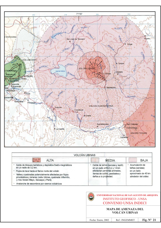
Mapa de Amenaza del Volcán Ubinas

Ubinas Volcano Hazard Map

Ubinas, Peru, 2002

Figure 21 in: Instituto Geológico Minero y Metalúrgico (INGEMMET). (2002). Estudio Geodinámico y Evaluación de peligros de las localidades de Omate, Puquina y Chucahuayo. Instituto Geologico Minero y Metalurgico (INGEMMET), Instituto Nacional de Defensa Civil (INDECI), Universidad Nacional de San Agustin (UNSA), & Programa de las Naciones Unidas para El Desarrollo (PNUD).


This map was produced by an official agency, but is NOT the most recent, most complete, or main operational map. For the current operational hazard map, please consult the proper institutional authorities.


Click on image for full-size map. If link seems broken, try the archived version.

Map Data

Map ID1015
Hazard Process(es)Ballistics; Debris avalanches; Lahars; Lava flows; PDCs; Tephra fall
Hazard Zone PresentationHazard level-focused: All or most hazards are combined by hazard level on a main map panel
Temporal ScaleBackground, or long-term, map
Spatial ScaleVolcano and surrounding area
Publication FormatFigure in a hazard assessment or mitigation plan
Zonation Method(s)Geologic history
Zonation Model(s)
Scenario(s) ConsideredNo scenarios were discernable from the map
Hazard Zone Label(s)Qualitative relative probability (e.g. high-medium-low)
Probability Definition(s)Qualitative relative probability (e.g. high-medium-low)
PurposeMultiple: intended for multiple purposes including general hazard awareness, planning, and crisis management
AudienceMultiple audiences (usually the public, civil authorities, and land-use planners)
Language(s)Spanish
Basemap(s)Contour lines
Basemap overlay(s)Street map
DiemsionalityPlanimetric (2D or map) view
Color SchemeDark to Light (color)
Go to Global Volcanism Program page for Ubinas →