← Back to Search Results

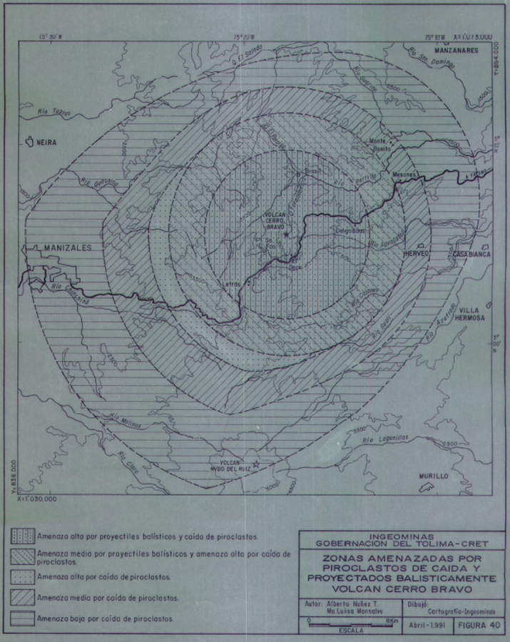
Zonas Amenazadas por Piroclasticos de Caida y Proyectados Balisticamente Volcan Cerro Bravo

Areas Threatened by Pyroclastic Fall and Ballistic Projectiles Cerro Bravo Volcano

Cerro Bravo, Colombia, 1991

Figure 40 in: Monsalve, M.L. (1991). Mapa Preliminar de Amenaza Volcanica del Volcan Cerro Bravo. Instituto de Investigaciones en Geociencias Minera y Quimica (INGEOMINAS), 130 p.


This map was produced by an official agency, but is NOT the most recent, most complete, or main operational map. For the current operational hazard map, please consult the proper institutional authorities.


Click on image for full-size map. If link seems broken, try the archived version.

Map Set

Monsalve, M.L. (1991). Mapa Preliminar de Amenaza Volcanica del Volcan Cerro Bravo. Instituto de Investigaciones en Geociencias Minera y Quimica (INGEOMINAS), 130 p.
http://recordcenter.sgc.gov.co/B1/11002000002142/documento/pdf/0101021421101000.pdf

Other Maps In Set:

Map Data

Map ID1245
Hazard Process(es)Ballistics; Tephra fall
Hazard Zone PresentationSingle hazard: A single hazard process is represented on a main map panel
Temporal ScaleBackground, or long-term, map
Spatial ScaleVolcano and surrounding area
Publication FormatFigure in a hazard assessment or mitigation plan
Zonation Method(s)Geologic history
Zonation Model(s)
Scenario(s) ConsideredNo scenarios were discernable from the map
Hazard Zone Label(s)Qualitative relative probability (e.g. high-medium-low)
Probability Definition(s)Qualitative relative probability (e.g. high-medium-low)
PurposeMultiple: intended for multiple purposes including general hazard awareness, planning, and crisis management
AudienceMultiple audiences (usually the public, civil authorities, and land-use planners)
Language(s)Spanish
Basemap(s)Contour lines
Basemap overlay(s)Street map
DiemsionalityPlanimetric (2D or map) view
Color SchemeSymbols and/or lines only
Go to Global Volcanism Program page for Cerro Bravo →