← Back to Search Results

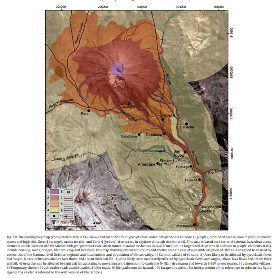
The contingency map (completed in May 2006) shows and identifies four types of color-coded risk-prone areas

Ubinas, Peru, 2006

Figure 10 in: Rivera, M., Thouret, J. C., Mariño, J., Berolatti, R., & Fuentes, J. (2010). Characteristics and management of the 2006–2008 volcanic crisis at the Ubinas volcano (Peru). Journal of Volcanology and Geothermal Research, 198(1-2), p. 19-34. https://doi.org/10.1016/j.jvolgeores.2010.07.020


This map was produced by an official agency, but is NOT the most recent, most complete, or main operational map. For the current operational hazard map, please consult the proper institutional authorities.


Click on image for full-size map. If link seems broken, try the archived version.

Map Set

Rivera, M., Thouret, J. C., Mariño, J., Berolatti, R., & Fuentes, J. (2010). Characteristics and management of the 2006–2008 volcanic crisis at the Ubinas volcano (Peru). Journal of Volcanology and Geothermal Research, 198(1-2), p. 19-34. https://doi.org/10.1016/j.jvolgeores.2010.07.020
https://doi.org/10.1016/j.jvolgeores.2010.07.020

Other Maps In Set:

Map Data

Map ID1299
Hazard Process(es)Access or danger zone; Debris avalanches; Lahars; Lava flows; PDCs; Tephra fall
Hazard Zone PresentationHazard level-focused: All or most hazards are combined by hazard level on a main map panel
Temporal ScaleBackground, or long-term, map
Spatial ScaleVolcano and surrounding area
Publication FormatFigure in a journal article
Zonation Method(s)Derived/simplified from another map
Zonation Model(s)
Scenario(s) ConsideredSeason or weather; Size, VEI, or intensity
Hazard Zone Label(s)Access (exclusion, danger, or safe zones)
Probability Definition(s)Qualitative relative probability (e.g. high-medium-low)
PurposeCrisis management and response: Intended to be used for managing, responding to, and taking action during an eruption; often includes evacuation routes, access restrictions, actions to take, etc.
AudienceMultiple audiences (usually the public, civil authorities, and land-use planners)
Language(s)English
Basemap(s)Satellite image
Basemap overlay(s)Street map
DiemsionalityPlanimetric (2D or map) view
Color SchemeRed to Yellow
Go to Global Volcanism Program page for Ubinas →