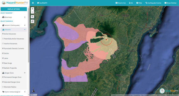
HazardHunterPH Kanlaon
Kanlaon, Philippines, Year unknown
GeoRisk Philippines. HazardHunterPH.
This map was produced by an official agency, but may not be the most recent, most complete, or main operational map.
For the current operational hazard map, please consult the proper institutional authorities.

Click on thumbnail for full-size map. We do not have copyright permission to display the full-size image. If you are the copyright holder and wish to provide copyright, please contact us at admin@volcanichazardmaps.org. If link seems broken, try the archived version.
Simplified, modified, or derived from:
- Kanlaon Volcano Lahar Hazard Map
- Kanlaon Volcano Lava Flow Hazard Map
- Kanlaon Volcano Pyroclastic Flow Hazard Map
Map Data
Map ID | 1307 |
---|---|
Hazard Process(es) | Access or danger zone; Lahars; PDCs |
Hazard Zone Presentation | Hazard process-focused: Most hazard processes are separated by hazard process type on a main map panel |
Temporal Scale | Background, or long-term, map |
Spatial Scale | User selectable |
Publication Format | Interactive web-based map |
Zonation Method(s) | Derived/simplified from another map |
Zonation Model(s) | |
Scenario(s) Considered | No scenarios were discernable from the map |
Hazard Zone Label(s) | Access (exclusion, danger, or safe zones); Hazard process name; Qualitative relative probability (e.g. high-medium-low) |
Probability Definition(s) | Qualitative relative probability (e.g. high-medium-low) |
Purpose | Multiple: intended for multiple purposes including general hazard awareness, planning, and crisis management |
Audience | Multiple audiences (usually the public, civil authorities, and land-use planners) |
Language(s) | English |
Basemap(s) | User selectable |
Basemap overlay(s) | Street map |
Diemsionality | Planimetric (2D or map) view |
Color Scheme | Purple to Yellow |