
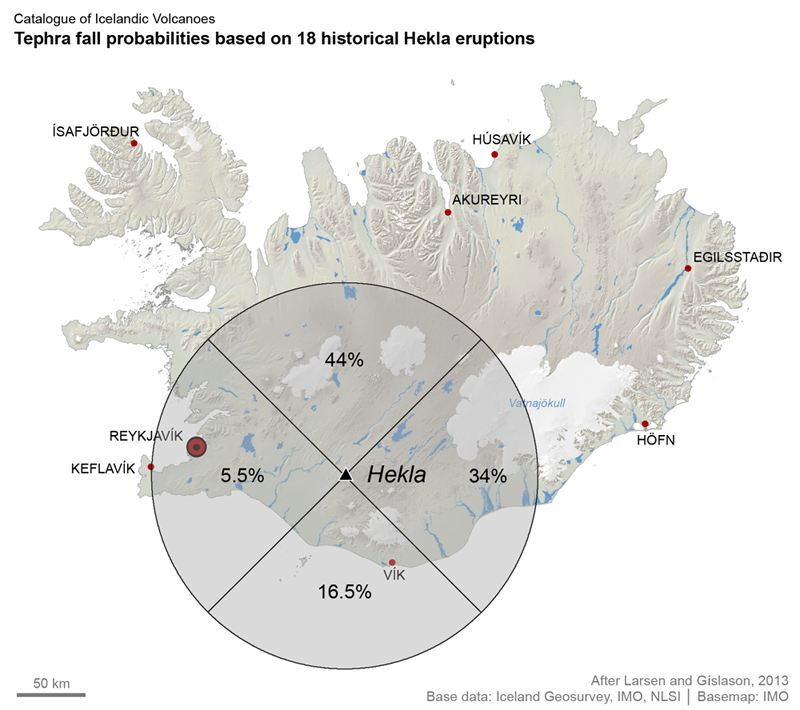
Tephra fall probabilities based on 18 historical Hekla eruptions
Hekla, Iceland, 2019
Larsen, G. & Thordarson, T. (2019). Hekla. In: Oladottir, B., Larsen, G. & Guðmundsson, M. T. Catalogue of Icelandic Volcanoes. Iceland Meteorological Office (IMO), Univeristy of Iceland, and Civil Protection Department of the National Commissioner of the Iceland Police (CPD-NCIP). https://icelandicvolcanos.is//index.html (Simplified from: Larsen & Gíslason 2013)
This map was produced by an official agency, but may not be the most recent, most complete, or main operational map.
For the current operational hazard map, please consult the proper institutional authorities.
Click on image for full-size map. If link seems broken, try the archived version.
Larsen, G. & Thordarson, T. (2019). Hekla. In: Oladottir, B., Larsen, G. & Guðmundsson, M. T. Catalogue of Icelandic Volcanoes. Iceland Meteorological Office (IMO), Univeristy of Iceland, and Civil Protection Department of the National Commissioner of the Iceland Police (CPD-NCIP). http://icelandicvolcanos.is/?volcano=HEK#Map Set
http://icelandicvolcanos.is/?volcano=HEK#
Other Maps In Set: