
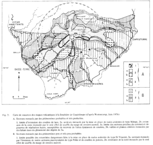
Carte de zonation des risques volcaniques á la Soufrière de Guadeloupe (d'ápres Westercamp, Juin 1976)
Zonation map of volcanic risks at Soufrière in Guadeloupe (after Westercamp, June 1976)
Soufrière Guadeloupe, Guadeloupe [France], 1981
Figure 2 in: Westercamp, D. (1981). Cartographie du risque volcanique a la soufriere de guadeloupe: Retrospective et tendance actuelle. Bulletin of the International Association of Engineering Geology-Bulletin de l'Association Internationale de Géologie de l'Ingénieur, 23(1), p. 25-32. https://doi.org/10.1007/BF02594723
This hazard map is the result of scientific research and was published in academic literature.
It is presented here to serve as an example of the map type or the map-making methodology. It is NOT the official, operational map. For the current operational hazard map, please consult the proper institutional authorities.
Click on thumbnail for full-size map. We do not have copyright permission to display the full-size image. If you are the copyright holder and wish to provide copyright, please contact us at admin@volcanichazardmaps.org.
Map Set
Westercamp, D. (1981). Cartographie du risque volcanique a la soufriere de guadeloupe: Retrospective et tendance actuelle. Bulletin of the International Association of Engineering Geology-Bulletin de l'Association Internationale de Géologie de l'Ingénieur, 23(1), p. 25-32. https://doi.org/10.1007/BF02594723
https://doi.org/10.1007/BF02594723
Other Maps In Set:
- Carte montrant les zones susceptibles d'être menacées par une éventuelle éruption de type péléen du volcan de la Soufrière de Guadeloupe (d'ápres Barrabe 1960)
- Nouvelle présentation après modification de la carte de zonation des risques volcaniques à la Soufrière de Guadeloupe de Juin 1976 (d'après Westercamp, Février 1977)
- Carte de zonation des risques d'éruption phréatique à la Soufrière de Guadeloupe (d'après Westercamp 1977b)
- Carte de zonation des risques d'éruption magmatique à la Soufrière de Guadeloupe