
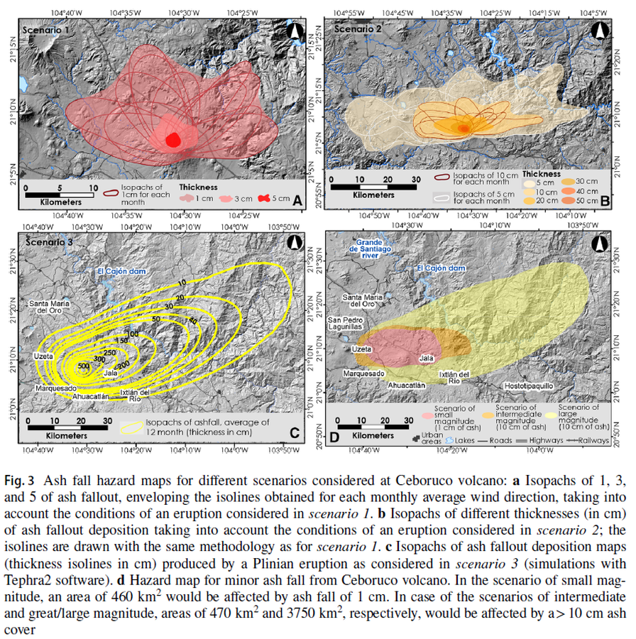
Ash fall hazard maps for different scenarios considered at Ceboruco volcano
Ceboruco, Mexico, 2019
Figure 3 in: Sieron, K., Ferrés, D., Siebe, C., Constantinescu, R., Capra, L., Connor, C., Connor, L., Groppelli, G. & Zuccolotto, K.G. (2019). Ceboruco hazard map: part II—modeling volcanic phenomena and construction of the general hazard map. Natural Hazards, 96(2), p. 893-933. https://doi.org/10.1007/s11069-019-03577-5
This hazard map is the result of scientific research and was published in academic literature.
It is presented here to serve as an example of the map type or the map-making methodology. It is NOT the official, operational map. For the current operational hazard map, please consult the proper institutional authorities.
Click on image for full-size map.
Map Set
Sieron, K., Ferrés, D., Siebe, C., Constantinescu, R., Capra, L., Connor, C., Connor, L., Groppelli, G. & Zuccolotto, K. G. (2019). Ceboruco hazard map: part II—modeling volcanic phenomena and construction of the general hazard map. Natural Hazards, 96(2), p. 893-933. https://doi.org/10.1007/s11069-019-03577-5
https://doi.org/10.1007/s11069-019-03577-5
Other Maps In Set:
- Hazard map for the emission of ballistics from Ceboruco volcano
- The hazard map for lava flows at Ceboruco volcano
- Hazard map considering pyroclastic flows at Ceboruco volcano
- Susceptibility map for lahar flooding
- Hazard map for scenario 1 (small magnitude and highest probability) showing the areas affected by lava flows and ash fallout
- Hazard map for scenario 2 (intermediate magnitude and probability of occurrence), showing the areas affected by ash fallout (N–NE) and the different types of flows: lava flows, PDCs, and lahars covering the entire surrounding valley
- Hazard map for scenario 3 (greatest magnitude and lowest likelihood)
- Areas affected by volcanic products from eruptions of different magnitude (Scenarios 1-3)