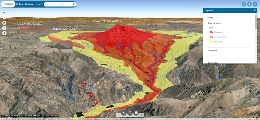
← Back to Search Results

Volcan Ubinas 3D

Ubinas Volcano 3D

Ubinas, Peru, 2019

Instituto Geológico Minero y Metalúrgico (INGEMMET). (2019). Volcan Ubinas 3D. Mapa de Peligros Volcanico Interativo 3D.


This map was produced by an official agency, but may not be the most recent, most complete, or main operational map. For the current operational hazard map, please consult the proper institutional authorities.


Click on image for full-size map.

Map Data

Map ID1432
Hazard Process(es)Lahars; Tephra fall; Unstated or all hazards
Hazard Zone PresentationGrouped by process (e.g. flowage/fall hazards) on a main map panel
Temporal ScaleBackground, or long-term, map
Spatial ScaleUser selectable
Publication FormatInteractive web-based map
Zonation Method(s)Derived/simplified from another map
Zonation Model(s)
Scenario(s) ConsideredSize, VEI, or intensity; Specific past eruption
Hazard Zone Label(s)Qualitative relative probability (e.g. high-medium-low)
Probability Definition(s)Qualitative relative probability (e.g. high-medium-low)
PurposeMultiple: intended for multiple purposes including general hazard awareness, planning, and crisis management
AudienceGeneral public and/or media
Language(s)Spanish
Basemap(s)User selectable
Basemap overlay(s)Street map
DiemsionalityView angle is changeable by user
Color SchemeRed to Yellow
Go to Global Volcanism Program page for Ubinas →