← Back to Search Results

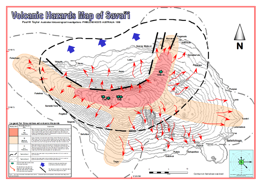
Volcanic Hazards Map of Savai'i

Savai'i, Samoa, 1999

Insert in: Taylor, P. & Talia, L. (1999). Volcanic Hazards Assessment of Savai'i, Samoa. Pacific Islands Applied Geoscience Commission (SOPAC) Technical Report 295, 25 p.


This map was produced by an official agency, but is NOT the most recent, most complete, or main operational map. For the current operational hazard map, please consult the proper institutional authorities.


Click on image for full-size map.

Map Data

Map ID1465
Hazard Process(es)Debris avalanches; Lahars; Lava flows; PDCs; Surges; Tephra fall; Vent-opening hazards
Hazard Zone PresentationHazard process-focused: Most hazard processes are separated by hazard process type on a main map panel
Temporal ScaleBackground, or long-term, map
Spatial ScaleIsland
Publication FormatPoster-style map insert in hazard assessment
Zonation Method(s)Geologic history
Zonation Model(s)
Scenario(s) ConsideredMost-likely; Source location or direction
Hazard Zone Label(s)Estimated value or Hazard Impact Metric; Hazard process name; Qualitative relative probability (e.g. high-medium-low)
Probability Definition(s)Qualitative relative probability (e.g. high-medium-low)
PurposeMultiple: intended for multiple purposes including general hazard awareness, planning, and crisis management
AudienceMultiple audiences (usually the public, civil authorities, and land-use planners)
Language(s)English
Basemap(s)Contour lines
Basemap overlay(s)
DiemsionalityPlanimetric (2D or map) view
Color SchemeRed to Yellow
Go to Global Volcanism Program page for Savai'i →