
Volcanic Hazard Map of Savo
Savo, Solomon Islands, 2016
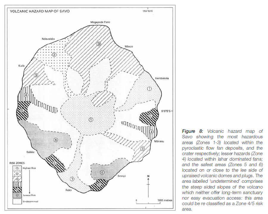
Figure 8 in: Petterson, M.G., Tolia, D., Papabatu, A., Toba, T., & Qoptoto, C. (2016). Volcanic Hazard assessment of Savo Volcano, Solomon Islands, SW Pacific. In: Taylor, P.W. (Ed.) Volcanic Hazards and Emergency Management in the Southwest Pacific, SPC Technical Bulletin, SPC00017, p. 151-169
This map was produced by an official agency, but is NOT the most recent, most complete, or main operational map.
For the current operational hazard map, please consult the proper institutional authorities.
Click on image for full-size map.
Map Set
Petterson, M.G., Tolia, D., Papabatu, A., Toba, T., & Qoptoto, C. (2016). Volcanic Hazard assessment of Savo Volcano, Solomon Islands, SW Pacific. In: Taylor, P.W. (Ed.) Volcanic Hazards and Emergency Management in the Southwest Pacific, SPC Technical Bulletin, SPC00017, p. 151-169
https://www.researchgate.net/profile/Michael_Petterson2/publication/322632753_A_volcanic_hazard_assessment_of_Savo_volcano_Solomon_Islands/links/5a64fe5c0f7e9b6b8fdbcc35/A-volcanic-hazard-assessment-of-Savo-volcano-Solomon-Islands.pdf#page=112
Other Maps In Set: