
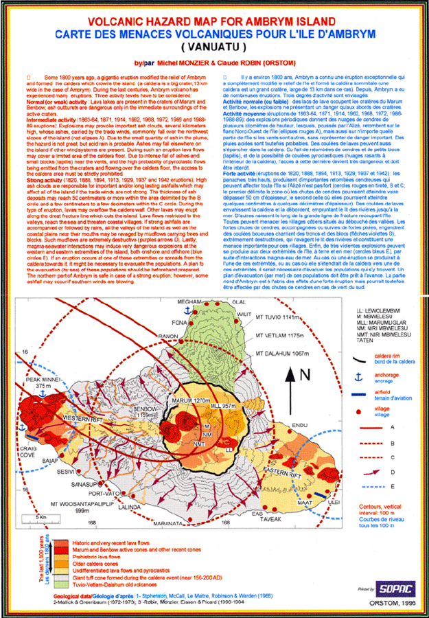
Volcanic Hazard Map for Ambrym Island - Carte des Menaces Volcaniques pour l'Ile d'Ambrym (Vanuatu)
Ambrym, Vanuatu, 1996
Appendix 1, Page 103 (in reprint) in: Monzier, M. & Robin, C. (1996). Volcanic Hazard Map for Ambrym Island - Carte des Menaces Volcaniques pour l'Ile d'Ambrym (Vanuatu). ORSTOM. (Reprinted in: Esau Wate, J. (2016). National Disaster Management Structure, Volcanic Alert Levels, Emergency Evacuation Plans and Public Awareness Strategies for Vanuatu. In: Taylor, P.W. (Ed.) Volcanic Hazards and Emergency Management in the Southwest Pacific, SPC Technical Bulletin, SPC00017, p. 96-105.)
This map was produced by an official agency, but is NOT the most recent, most complete, or main operational map.
For the current operational hazard map, please consult the proper institutional authorities.
Click on image for full-size map.
Map Set
Esau Wate, J. (2016). National Disaster Management Structure, Volcanic Alert Levels, Emergency Evacuation Plans and Public Awareness Strategies for Vanuatu. In: Taylor, P.W. (Ed.) Volcanic Hazards and Emergency Management in the Southwest Pacific, SPC Technical Bulletin, SPC00017, p. 96-105
https://www.researchgate.net/profile/Michael_Petterson2/publication/322632753_A_volcanic_hazard_assessment_of_Savo_volcano_Solomon_Islands/links/5a64fe5c0f7e9b6b8fdbcc35/A-volcanic-hazard-assessment-of-Savo-volcano-Solomon-Islands.pdf
Other Maps In Set: