
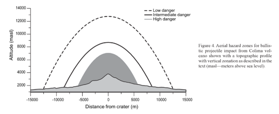
Aerial hazard zones for ballistic impact from Colima volcano shown with a topographic profile with vertical zonation as described in the text
Colima, Mexico, 2006
Figure 4 in: Alatorre-Ibargüengoitia, M.A., Delgado-Granados, H., & Farraz-Montes, I.A. (2006). Hazard zoning for ballistic impact during volcanic explosions at Volcán de Fuego de Colima (México). In: Siebe, C., Macías Gerardo, J.L., Aguirre-Díaz, J. (Eds.). Neogene-Quaternary Continental Margin Volcanism: A perspective from México. Geological Society of America, Special Papers 402, p. 209-216. https://doi.org/10.1130/2006.2402(09)
This hazard map is the result of scientific research and was published in academic literature.
It is presented here to serve as an example of the map type or the map-making methodology. It is NOT the official, operational map. For the current operational hazard map, please consult the proper institutional authorities.
Click on image for full-size map.
Map Set
Alatorre-Ibargüengoitia, M.A., Delgado-Granados, H., & Farraz-Montes, I.A. (2006). Hazard zoning for ballistic impact during volcanic explosions at Volcán de Fuego de Colima (México). In: Siebe, C., Macías Gerardo, J.L., Aguirre-Díaz, J. (Eds.). Neogene-Quaternary Continental Margin Volcanism: A perspective from México. Geological Society of America, Special Papers 402, p. 209-216. https://doi.org/10.1130/2006.2402(09)
https://doi.org/10.1130/2006.2402(09)
Other Maps In Set: