← Back to Search Results

Piano Nazionale di Protezione Civile Campi Flegrei

National Civil Protection Plan Campi Flegrei

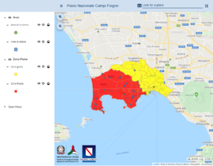
Campi Flegrei, Italy, Year unknown

Dipartimento della Protezione Civile. Piano Nazionale di Protezione Civile Campi Flegrei.


This map was produced by an official agency, but may not be the most recent, most complete, or main operational map. For the current operational hazard map, please consult the proper institutional authorities.


Click on thumbnail for full-size map. We do not have copyright permission to display the full-size image. If you are the copyright holder and wish to provide copyright, please contact us at admin@volcanichazardmaps.org.

Map Data

Map ID1507
Hazard Process(es)PDCs; Tephra fall
Hazard Zone PresentationHazard level-focused: All or most hazards are combined by hazard level on a main map panel
Temporal ScaleBackground, or long-term, map
Spatial ScaleUser selectable
Publication FormatInteractive web-based map
Zonation Method(s)Derived/simplified from another map
Zonation Model(s)
Scenario(s) ConsideredSize, VEI, or intensity; Style or type
Hazard Zone Label(s)Qualitative relative probability (e.g. high-medium-low)
Probability Definition(s)Qualitative relative probability (e.g. high-medium-low)
PurposeLand-use planning: Intended to inform citing of facilities, building restrictions, resource management, and infrastructure development
AudienceMultiple audiences (usually the public, civil authorities, and land-use planners)
Language(s)English; Italian
Basemap(s)Topographic map (colored contour map)
Basemap overlay(s)Street map
DiemsionalityPlanimetric (2D or map) view
Color SchemeRed to Yellow
Go to Global Volcanism Program page for Campi Flegrei →