
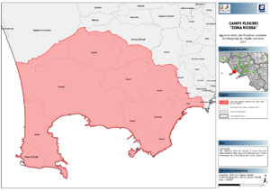
Campi Flegrei "Zona Rossa"
Campi Flegrei "Red Zone"
Campi Flegrei, Italy, 2014
Dipartimento della Protezione Civile. (2014). Campi Flegrei "Zona Rossa" - Aggiornamento Pianificazione Nazionale di Emergenza per Rischio Vulcanico.
This map was produced by an official agency, but may not be the most recent, most complete, or main operational map.
For the current operational hazard map, please consult the proper institutional authorities.
Click on thumbnail for full-size map. We do not have copyright permission to display the full-size image. If you are the copyright holder and wish to provide copyright, please contact us at admin@volcanichazardmaps.org. If link seems broken, try the archived version.