
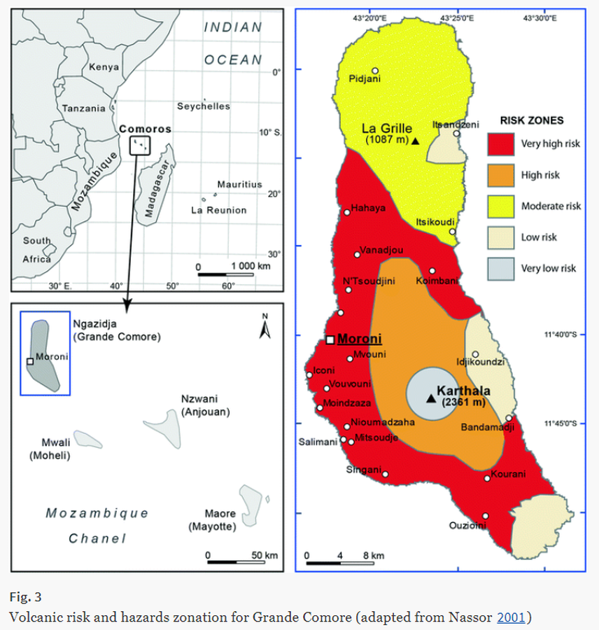
Volcanic risk and hazards zonation for Grande Comore
Karthala, Comoros, 2001
Figure 3 in: Komorowski JC., Morin J., Jenkins S., & Kelman I. (2016) Challenges of Volcanic Crises on Small Islands States. In: Fearnley C.J., Bird D.K., Haynes K., McGuire W.J., Jolly G. (eds) Observing the Volcano World. Advances in Volcanology. International Association of Volcanology and Chemistry of the Earth’s Interior – IAVCEI. Springer. https://doi.org/10.1007/11157_2015_15. Adapted from: Nassor, H. (2001) Contribution à l’étude du risque volcanique sur les grands volcans boucliers basaltiques: le Karthala et le Piton de la Fournaise, unpublished PhD dissertation, University of La Réunion, 218 p.
This hazard map is the result of scientific research and was published in academic literature.
It is presented here to serve as an example of the map type or the map-making methodology. It is NOT the official, operational map. For the current operational hazard map, please consult the proper institutional authorities.
Click on image for full-size map.
Map Set
Komorowski JC., Morin J., Jenkins S., & Kelman I. (2016) Challenges of Volcanic Crises on Small Islands States. In: Fearnley C.J., Bird D.K., Haynes K., McGuire W.J., Jolly G. (eds) Observing the Volcano World. Advances in Volcanology. International Association of Volcanology and Chemistry of the Earth’s Interior – IAVCEI. Springer. https://doi.org/10.1007/11157_2015_15.
https://doi.org/10.1007/11157_2015_15
Other Maps In Set: