← Back to Search Results

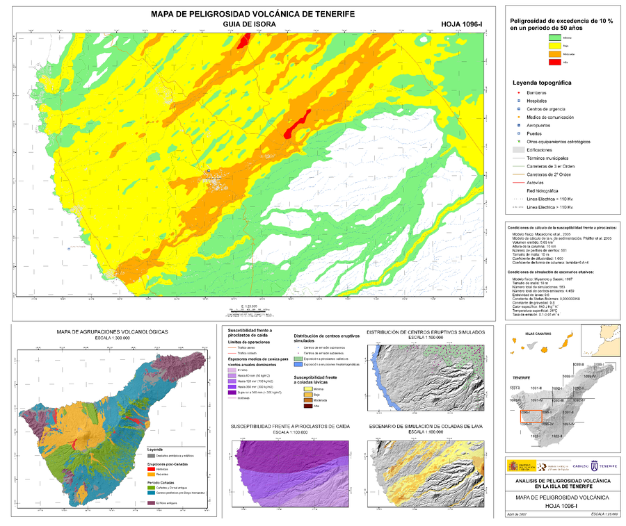
Analisis de Peligrosidad Volcánica en la Isla de Tenerife - Mapa de Peligrosidad Volcánica - Guia de Isora

Volcanic Hazard Analysis on the Island of Tenerife - Volcanic Hazard Map - Guia de Isora

Tenerife, Spain, 2007

Sheet 1096-I in: Instituto Geológico y Minero de España (IGME). (2006). Plan Territorial Especial de Ordenación para la Prevención de Riesgos. Documento Cartográfico (Planos de Información - Anexo Cartografía Peligrosidad Volcánica).


This map was produced by an official agency, but may not be the most recent, most complete, or main operational map. For the current operational hazard map, please consult the proper institutional authorities.


Click on image for full-size map. If link seems broken, try the archived version.

Map Set

Cabildo Tenerife. (2012). Plan Territorial Especial de Ordenación para la Prevención de Riesgos. Documento Cartográfico (Planos de Información - Anexo Cartografía Peligrosidad Volcánica).
https://www.tenerife.es/planes/PTEOPrevRiesgos/PTEOPrevindex.htm

Other Maps In Set:

Map Data

Map ID1540
Hazard Process(es)Ballistics; Explosion hazards, unspecific; Lava flows; Tephra fall; Vent-opening hazards
Hazard Zone PresentationHazard level- and process-focused: Hazards are both combined by hazard level and separated by hazard process type on a main map and series of insets
Temporal ScaleBackground, or long-term, map
Spatial ScalePart of volcano (flank or drainage)
Publication FormatPoster-style map insert in hazard assessment
Zonation Method(s)Probabilistic modeling; Scenario modeling; Spatial modeling
Zonation Model(s)Generic buffer around a model run (No reference); HAZMAP (Macedonio et al. 2005); Unnamed ballistic model [Instituto Geológico y Minero de España (2006)] (Instituto Geológico y Minero de España 2006); Unnamed cellular automata lava flow model [Miyamoto & Sasaki (1997)] (Miyamoto & Sasaki 1997); Unnamed Cox process model [Diggle & Milne (1983)] (Diggle & Milne 1983)
Scenario(s) ConsideredComposition; Season or weather; Size, VEI, or intensity; Source location or direction
Hazard Zone Label(s)Access (exclusion, danger, or safe zones); Estimated value or Hazard Impact Metric; Hazard process name; Qualitative relative probability (e.g. high-medium-low)
Probability Definition(s)Numeric probability; Qualitative relative probability (e.g. high-medium-low)
PurposeLand-use planning: Intended to inform citing of facilities, building restrictions, resource management, and infrastructure development
AudienceLand-use planners, city planners, government officials, etc.
Language(s)Spanish
Basemap(s)Street map
Basemap overlay(s)
DiemsionalityPlanimetric (2D or map) view
Color SchemeRed to Green
Go to Global Volcanism Program page for Tenerife →