
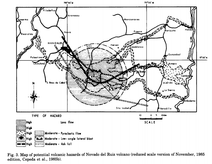
Map of potential volcanic hazards of Nevado del Ruiz volcano (reduced scale version of November, 1985 edition)
Nevado del Ruiz, Colombia, 1990
Figure 3 in: Parra, E. & Cepeda, H. (1990). Volcanic hazard maps of the Nevado del Ruiz volcano, Colombia. Journal of Volcanology and Geothermal Research, 42, p. 177-127. https://doi.org/10.1016/0377-0273(90)90073-O (Modified from: Cepeda et al. 1985)
This map was produced by an official agency, but is NOT the most recent, most complete, or main operational map.
For the current operational hazard map, please consult the proper institutional authorities.
Click on thumbnail for full-size map. We do not have copyright permission to display the full-size image. If you are the copyright holder and wish to provide copyright, please contact us at admin@volcanichazardmaps.org.
Map Set
Parra, E. & Cepeda, H. (1990). Volcanic hazard maps of the Nevado del Ruiz volcano, Colombia. Journal of Volcanology and Geothermal Research, 42, p. 177-127. https://doi.org/10.1016/0377-0273(90)90073-O
https://doi.org/10.1016/0377-0273(90)90073-O
Other Maps In Set:
- Preliminary map of volcanic hazards of Nevado del Ruiz volcano (reduced scale version of October 1985 edition)
- Map of potential volcanic hazards of Nevado del Ruiz volcano (reduced scale version of October, 1986 edition)
- Map of probabilistic zoning of severity of volcanic hazards of Nevado del Ruiz volcano