← Back to Search Results

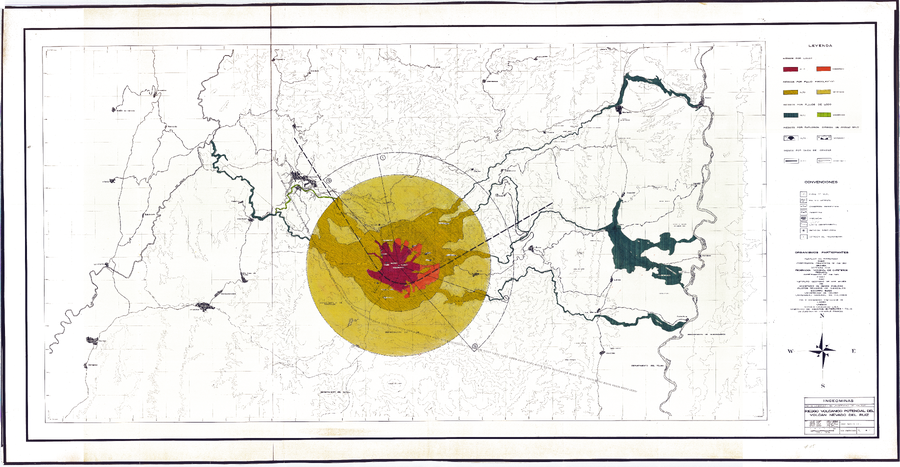
Riesgo Volcanico Potencial del Volcan Nevado del Ruiz (Noviembre 12 de 1985)

Potential Volcanic Risk of the Nevado del Ruiz Volcano (November 12, 1985)

Nevado del Ruiz, Colombia, 1985

Cepeda, H., James, M., Murcia, L.A., Parra, E., Salinas, R.Y. & Vergara, H. (1985). Mapa de Riesgos Volcánicos Potenciales del Nevado del Ruiz. Esc. 1:100.000. Memoria Explicativa, 28 pp. Instituto Colombiano de Geología y Minería (INGEOMINAS). Medellin, Nov. 12/85.


This map was produced by an official agency, but is NOT the most recent, most complete, or main operational map. For the current operational hazard map, please consult the proper institutional authorities.


Click on image for full-size map. If link seems broken, try the archived version.

Map Data

Map ID1562
Hazard Process(es)Lahars; Lateral or directed blasts; Lava flows; PDCs; Tephra fall
Hazard Zone PresentationHazard process-focused: Most hazard processes are separated by hazard process type on a main map panel
Temporal ScaleBackground, or long-term, map
Spatial ScaleVolcano and surrounding area
Publication FormatMap sheet or poster
Zonation Method(s)Analog geology; Geologic history
Zonation Model(s)
Scenario(s) ConsideredNo scenarios were discernable from the map
Hazard Zone Label(s)Qualitative relative probability (e.g. high-medium-low)
Probability Definition(s)Qualitative relative probability (e.g. high-medium-low)
PurposeMultiple: intended for multiple purposes including general hazard awareness, planning, and crisis management
AudienceMultiple audiences (usually the public, civil authorities, and land-use planners)
Language(s)Spanish
Basemap(s)Contour lines
Basemap overlay(s)Street map
DiemsionalityPlanimetric (2D or map) view
Color SchemeRed to Green
Go to Global Volcanism Program page for Nevado del Ruiz →