
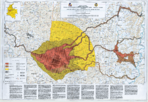
Mapa de Amenaza Volcanica Potencial del Nevado del Ruiz (Octubre 7 de 1986)
Nevado del Ruiz Potential Volcanic Threat Map (October 7, 1986)
Nevado del Ruiz, Colombia, 1986
Parra, E., Cepeda, H. & Thouret, J. C. (1986). Mapa de Amenaza Volcanica Potencial del Nevado del Ruiz (Octubre 7 de 1986). Esc. 1:100,000. Instituto Colombiano de Geología y Minería (INGEOMINAS). Bogota.
This map was produced by an official agency, but is NOT the most recent, most complete, or main operational map.
For the current operational hazard map, please consult the proper institutional authorities.
Click on image for full-size map. If link seems broken, try the archived version.