← Back to Search Results

Volcanic and Tsunami Risk Maps of Stromboli Island (Italy)

Stromboli, Italy, 2010

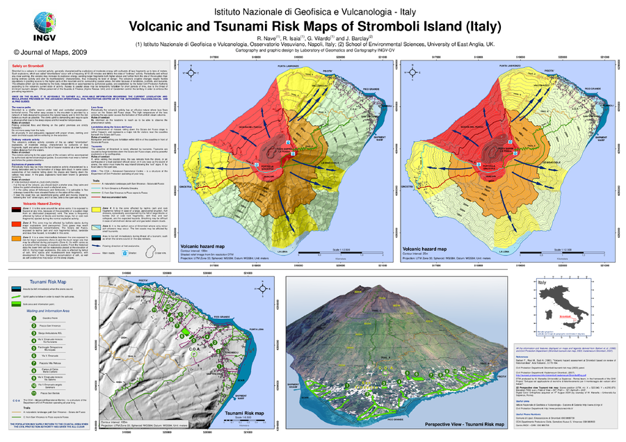
Supplemental Material in: Nave, R., Isaia, R., Vilardo, G., & Barclay, J. (2010). Re-assessing volcanic hazard maps for improving volcanic risk communication: application to Stromboli Island, Italy. Journal of Maps, 6(1), p. 260-269. https://doi.org/10.4113/jom.2010.1061


This map was produced by an official agency, but may not be the most recent, most complete, or main operational map. For the current operational hazard map, please consult the proper institutional authorities.


Click on image for full-size map.

Map Data

Map ID1589
Hazard Process(es)Ballistics; Debris avalanches; Explosion hazards, unspecific; Fire; Gas; Lava flows; PDCs; Tephra fall; Tsunami
Hazard Zone PresentationHazard level- and process-focused: Hazards are both combined by hazard level and separated by hazard process type on a series of small map panels of similar sizes
Temporal ScaleBackground, or long-term, map
Spatial ScaleIsland
Publication FormatPoster-style map insert in hazard assessment
Zonation Method(s)Derived/simplified from another map
Zonation Model(s)
Scenario(s) ConsideredSize, VEI, or intensity
Hazard Zone Label(s)Qualitative relative probability (e.g. high-medium-low)
Probability Definition(s)Qualitative relative probability (e.g. high-medium-low)
PurposeMultiple: intended for multiple purposes including general hazard awareness, planning, and crisis management
AudienceMultiple audiences (usually the public, civil authorities, and land-use planners)
Language(s)English
Basemap(s)Hillshade
Basemap overlay(s)Contour lines; Satellite image; Street map; Trail or hiking map
DiemsionalityMultiple view types on a series of small maps
Color SchemeRed to Yellow
Go to Global Volcanism Program page for Stromboli →