
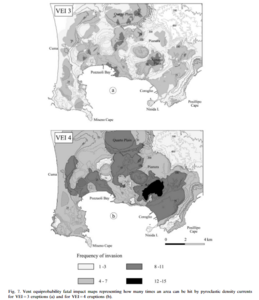
Vent equiprobability fatal impact maps representing how many times an area can be hit by pyroclastic density currents for VEI=3 eruptions and for VEI=4 eruptions
Campi Flegrei, Italy, 2002
Figure 7 in: Alberico, I., Lirer, L., Petrosino, P., & Scandone, R. (2002). A methodology for the evaluation of long-term volcanic risk from pyroclastic flows in Campi Flegrei (Italy). Journal of Volcanology and Geothermal Research, 116(1-2), p. 63-78. https://doi.org/10.1016/S0377-0273(02)00211-1
This hazard map is the result of scientific research and was published in academic literature.
It is presented here to serve as an example of the map type or the map-making methodology. It is NOT the official, operational map. For the current operational hazard map, please consult the proper institutional authorities.
Click on thumbnail for full-size map. We do not have copyright permission to display the full-size image. If you are the copyright holder and wish to provide copyright, please contact us at admin@volcanichazardmaps.org.