
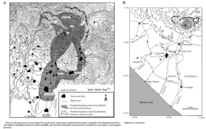
Hazards map of pyroclastic flows produced by central dome explosions based on four recognized events during the past 40 k.y., and small-size landslides produced by flank instability, and debris and hyperconcentrated flows produced by syneruptive or posteruptive processes.
Tacaná, Mexico-Guatemala, 2000
Figure 14 in: Macias, J. L., Espíndola, J. M., Garcia-Palomo, A., Scott, K. M., Hughes, S., & Mora, J. C. (2000). Late Holocene Peléan-style eruption at Tacaná volcano, Mexico and Guatemala: Past, present, and future hazards. Geological Society of America Bulletin, 112(8), p. 1234-1249. https://doi.org/10.1130/0016-7606(2000)112%3C1234:LHPEAT%3E2.0.CO;2
This map was produced by an official agency, but is NOT the most recent, most complete, or main operational map.
For the current operational hazard map, please consult the proper institutional authorities.
Click on thumbnail for full-size map. We do not have copyright permission to display the full-size image. If you are the copyright holder and wish to provide copyright, please contact us at admin@volcanichazardmaps.org. If link seems broken, try the archived version.