← Back to Search Results

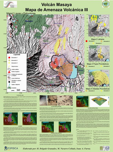
Volcán Masaya - Mapa de Amenaza Volcánica III

Masaya Volcano - Volcanic Threat Map III

Masaya, Nicaragua, 2004

Delgado, H., Navarro, M., & Farraz, I.A. (2004). Volcán Masaya Mapa de Amenaza Volcánica III. Instituto Nicaragüense de Estudios Territoriales (INETER) & Universidad Nacional Autónoma de México (UNAM).


This map was produced by an official agency, but may not be the most recent, most complete, or main operational map. For the current operational hazard map, please consult the proper institutional authorities.


Click on thumbnail for full-size map. We do not have copyright permission to display the full-size image. If you are the copyright holder and wish to provide copyright, please contact us at admin@volcanichazardmaps.org. If link seems broken, try the archived version.

Map Data

Map ID1621
Hazard Process(es)Debris avalanches (text only); Lahars; Lava flows; PDCs; Surges
Hazard Zone PresentationHazard process-focused: Most hazard processes are separated by hazard process type on a main map and series of insets
Temporal ScaleBackground, or long-term, map
Spatial ScaleVolcano and surrounding area
Publication FormatMap sheet or poster
Zonation Method(s)Scenario modeling
Zonation Model(s)Unknown flow model (Unknown reference)
Scenario(s) ConsideredUnknown
Hazard Zone Label(s)Scenario name
Probability Definition(s)Scenarios imply probability
PurposeMultiple: intended for multiple purposes including general hazard awareness, planning, and crisis management
AudienceMultiple audiences (usually the public, civil authorities, and land-use planners)
Language(s)Spanish
Basemap(s)Hillshade
Basemap overlay(s)Street map
DiemsionalityPlanimetric (2D or map) view
Color SchemeRed to Yellow
Go to Global Volcanism Program page for Masaya →