← Back to Search Results

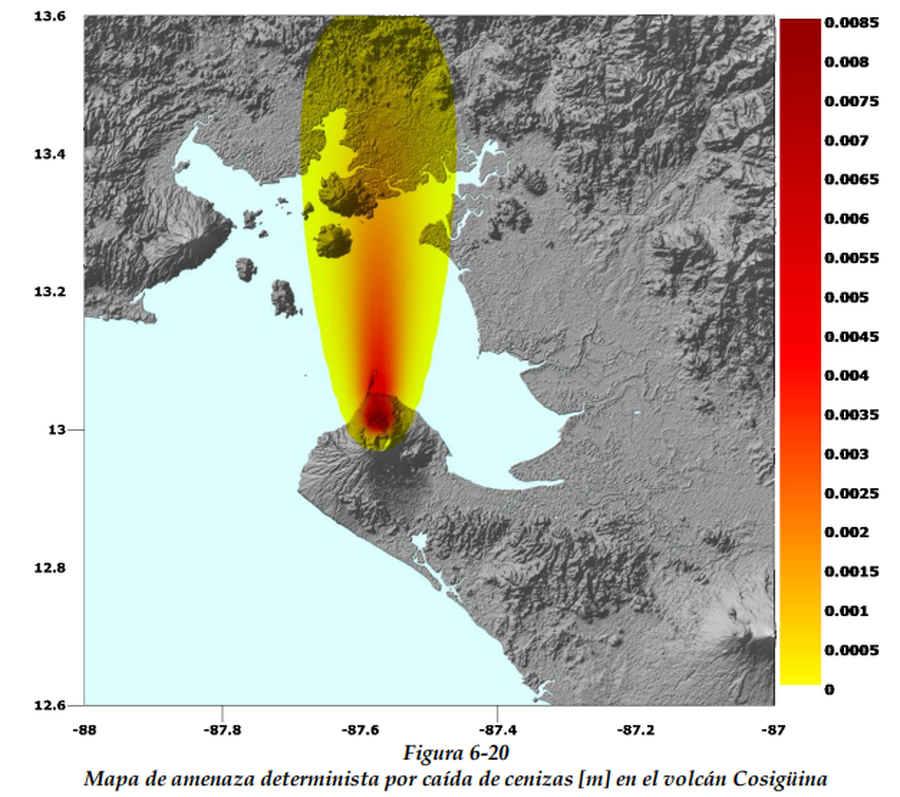
Mapa de amenaza determinista por caída de cenizas [m] en el volcán Cosigüina

Deterministic threat map for ash fall [m] at Cosigüina volcano

Cosigüina, Nicaragua, Year unknown

Figure 6-20 in: CAPRA Probabilistic Risk Assessment Initiative. Nicaragua - Tomo I Metodología De Modelación Probabilista De Riesgos Naturales. Informe Técnico ERN-CAPRA-t2-3 Modelación Probabilista De Amenazas Naturales.


This map may not be the most recent, most complete, or main operational map. For the current operational hazard map, please consult the proper institutional authorities.


Click on image for full-size map. If link seems broken, try the archived version.

Map Set

Comprehensive Approach to Probabilistic Risk Assessment (CAPRA) Initiative. Nicaragua - Tomo I Metodología De Modelación Probabilista De Riesgos Naturales. Informe Técnico ERN-CAPRA-t2-3 Modelación Probabilista De Amenazas Naturales.
https://www.ecapra.org/sites/default/files/documents/ERN-CAPRA-R7-T2-3%20-%20Modelaci%C3%B3n%20Probabilista%20de%20Amenazas%20Naturales_NIC.pdf

Other Maps In Set:

Map Data

Map ID1635
Hazard Process(es)Tephra fall
Hazard Zone PresentationSingle hazard: A single hazard process is represented on a main map panel
Temporal ScaleBackground, or long-term, map
Spatial ScaleVolcano and surrounding area
Publication FormatFigure in a hazard assessment or mitigation plan
Zonation Method(s)Scenario modeling
Zonation Model(s)ERN-Volcano (Comprehensive Approach to Probabilistic Risk Assessment (CAPRA) Initiative, ERN-CAPRA-T1-3); Unnamed advection-dispersion model [Folch & Felpeto (2005)] (Folch & Felpeto 2005)
Scenario(s) ConsideredSeason or weather; Size, VEI, or intensity
Hazard Zone Label(s)Estimated value or Hazard Impact Metric
Probability Definition(s)No probability definition was discernable from the map
PurposeLand-use planning: Intended to inform citing of facilities, building restrictions, resource management, and infrastructure development
AudienceMultiple audiences (usually the public, civil authorities, and land-use planners)
Language(s)Spanish
Basemap(s)Hillshade
Basemap overlay(s)
DiemsionalityPlanimetric (2D or map) view
Color SchemeRed to Yellow
Go to Global Volcanism Program page for Cosigüina →