
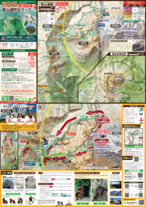
Mt. Unzen-dake Trail Volcanic Disaster Prevention Map
Unzendake, Japan, 2018
Volcano Disaster Management Councils of Mt. Unzen. (2018). Mt.Unzen-dake Trail Volcanic Disaster Prevention Map.
This map was produced by an official agency, but is NOT the most recent, most complete, or main operational map.
For the current operational hazard map, please consult the proper institutional authorities.
 If link seems broken, try the archived
version.
If link seems broken, try the archived
version.Volcano Disaster Management Councils of Mt. Unzen. (2018). Mt.Unzen-dake Trail Volcanic Disaster Prevention Map. Map Set
https://www.pref.nagasaki.jp/bunrui/anzen-anshin/bosai-kokuminhogo/bousaigyosei/kazan/
Map Data
Map ID 3005 Hazard Process(es) Access or danger zone; Ballistics; Explosion hazards, unspecific; Gas; Lava dome-related hazards; Lava flows; PDCs Hazard Zone Presentation Hazard level-focused: All or most hazards are combined by hazard level on a main map and series of insets Temporal Scale Background, or long-term, map Spatial Scale Multiple scales Publication Format Map sheet or poster Zonation Method(s) Derived/simplified from another map Zonation Model(s) Scenario(s) Considered Alert levels Hazard Zone Label(s) Access (exclusion, danger, or safe zones) Probability Definition(s) Qualitative relative probability (e.g. high-medium-low) Purpose Crisis management and response: Intended to be used for managing, responding to, and taking action during an eruption; often includes evacuation routes, access restrictions, actions to take, etc. Audience Tourists or visitors (often for national parks or hiking trails) Language(s) Japanese Basemap(s) Hillshade Basemap overlay(s) Contour lines; Trail or hiking map Diemsionality Planimetric (2D or map) view Color Scheme Purple to Yellow Volcanic Alert Level System https://global-valid.org/val-japan-20/