← Back to Search Results

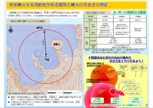
Assumed future eruption location and magnitude of eruption

Towada, Japan, 2018

Page 7 in: Towada Volcanic Hazards Mitigation Committee. (2018). Towada Volcano Hazard Expected Impact Area Map. Omori Prefecture Disaster Risk Management Division, Akita Prefecture Disaster Prevention Division, Nagano City General Affairs Division, Kosaka Town General Affairs Division.


This map was produced by an official agency, but may not be the most recent, most complete, or main operational map. For the current operational hazard map, please consult the proper institutional authorities.


Click on thumbnail for full-size map. We do not have copyright permission to display the full-size image. If you are the copyright holder and wish to provide copyright, please contact us at admin@volcanichazardmaps.org. If link seems broken, try the archived version.

Map Data

Map ID3050
Hazard Process(es)Vent-opening hazards
Hazard Zone PresentationSingle hazard: A single hazard process is represented on a main map panel
Temporal ScaleBackground, or long-term, map
Spatial ScaleVolcano and surrounding area
Publication FormatMap in a booklet, longer fact-sheet, handbook, or guidebook
Zonation Method(s)Geologic history
Zonation Model(s)
Scenario(s) ConsideredNo scenarios were discernable from the map
Hazard Zone Label(s)Hazard process name
Probability Definition(s)No probability definition was discernable from the map
PurposeHazard awareness: Intended for educating the audience about the extent and probability of volcanic hazard
AudienceGeneral public and/or media
Language(s)Japanese
Basemap(s)Hillshade
Basemap overlay(s)Contour lines; Street map
DiemsionalityPlanimetric (2D or map) view
Color SchemeSingle color
Go to Global Volcanism Program page for Towada →