
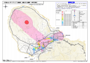
Hachijojima Volcano Hazard Map (Lava flow: Flank craters (base of volcano), 4 million m³ DRE)
Hachijojima, Japan, 2017
Hachijojima Volcano Disaster Prevention Council. (2017). Hachijojima volcano hazard map. Disaster Prevention Division, Bureau of General Affairs, Tokyo Metropolitan Government.
This map was produced by an official agency, but may not be the most recent, most complete, or main operational map.
For the current operational hazard map, please consult the proper institutional authorities.
Click on thumbnail for full-size map. We do not have copyright permission to display the full-size image. If you are the copyright holder and wish to provide copyright, please contact us at admin@volcanichazardmaps.org. If link seems broken, try the archived version.
Hachijojima Volcano Disaster Prevention Council. (2019). Hachijojima volcano evacuation plan. Disaster Prevention Division, Bureau of General Affairs, Tokyo Metropolitan Government.Map Set
https://www.bousai.metro.tokyo.lg.jp/_res/projects/default_project/_page_/001/003/342/hachijyo_hinan2019.pdf
Other Maps In Set: