← Back to Search Results

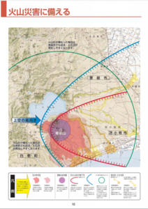
Prepare for a Volcanic Disaster

Tarumaeyama (Shikotsu), Japan, 2013

Page 10-11 in: Eniwa City Disaster Prevention Division. (2013). Disaster Prevention Guidebook. 21 p.


This map was produced by an official agency, but is NOT the most recent, most complete, or main operational map. For the current operational hazard map, please consult the proper institutional authorities.

Map Data

Map ID3184
Hazard Process(es)Ash-cloud surges; Ballistics; Lahars; PDCs; Tephra fall
Hazard Zone PresentationHazard process-focused: Most hazard processes are separated by hazard process type on a main map panel
Temporal ScaleBackground, or long-term, map
Spatial ScaleVolcano and surrounding area
Publication FormatMap in a booklet, longer fact-sheet, handbook, or guidebook
Zonation Method(s)Geologic history
Zonation Model(s)
Scenario(s) ConsideredSeason or weather; Specific past eruption; Style or type
Hazard Zone Label(s)Estimated value or Hazard Impact Metric; Hazard process name
Probability Definition(s)Qualitative relative probability (e.g. high-medium-low)
PurposeMultiple: intended for multiple purposes including general hazard awareness, planning, and crisis management
AudienceGeneral public and/or media
Language(s)Japanese
Basemap(s)Topographic map (colored contour map)
Basemap overlay(s)Contour lines; Hillshade; Street map
DiemsionalityPlanimetric (2D or map) view
Color SchemeRed to Blue
Go to Global Volcanism Program page for Tarumaeyama (Shikotsu) →