← Back to Search Results

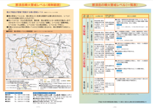
Nasudake volcanic alert level and regulation range

Nasudake, Japan, 2014

Page 11 in: Nasudake Volcano Disaster Prevention Council. (2014). Nasudake Volcano Disaster Prevention Handbook.


This map was produced by an official agency, but may not be the most recent, most complete, or main operational map. For the current operational hazard map, please consult the proper institutional authorities.


Click on thumbnail for full-size map. We do not have copyright permission to display the full-size image. If you are the copyright holder and wish to provide copyright, please contact us at admin@volcanichazardmaps.org. If link seems broken, try the archived version.

Map Set

Nasudake Volcano Disaster Prevention Council. (2014). Nasudake Volcano Disaster Prevention Handbook.
https://www.town.nasu.lg.jp/0030/info-0000000859-1.html

Other Maps In Set:

Map Data

Map ID3204
Hazard Process(es)Access or danger zone
Hazard Zone PresentationHazard level-focused: All or most hazards are combined by hazard level on a main map panel
Temporal ScaleBackground, or long-term, map
Spatial ScaleVolcano and surrounding area
Publication FormatMap in a booklet, longer fact-sheet, handbook, or guidebook
Zonation Method(s)Derived/simplified from another map
Zonation Model(s)
Scenario(s) ConsideredAlert levels
Hazard Zone Label(s)Access (exclusion, danger, or safe zones)
Probability Definition(s)Alert levels imply probability
PurposeHazard awareness: Intended for educating the audience about the extent and probability of volcanic hazard
AudienceGeneral public and/or media
Language(s)Japanese
Basemap(s)Contour lines
Basemap overlay(s)Street map; Trail or hiking map
DiemsionalityPlanimetric (2D or map) view
Color SchemeRed to Green
Go to Global Volcanism Program page for Nasudake →